2020s Maps of San Diego County, California
Explore 99 historic maps of San Diego County from the 2020s. These maps offer a rare glimpse into what life looked like during the 2020s — showing old roads, neighborhoods, homes, and landmarks that have changed or disappeared over time.
Whether you're researching your family's past, planning a metal detecting trip, or studying how San Diego County's landscape evolved across the 2020s, these high-resolution maps are a powerful tool for exploring the history of this region.
- Focus on a specific era: All maps on this page are from the 2020s, giving you a focused view of this time period.
- See what’s changed: Compare century-old streets, trails, and buildings to today's modern landscape using overlays and satellite layers.
- Research with precision: Use these maps for genealogy, historical research, land use analysis, or educational projects.
- View, download, or print: Maps are fully viewable online in high resolution, and can be downloaded or printed for your own records.
Start exploring San Diego County's history through authentic maps from the 2020s. This is your window into the past.
San Diego County, CA maps
(99)- 2021 Map of National City, 2021 Print
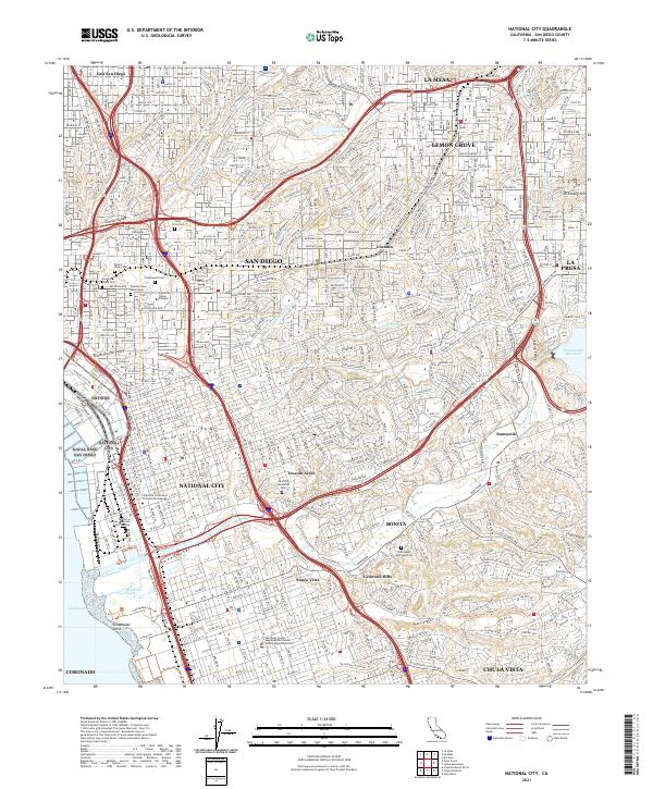 2021 National City2021 Print · USGSNational City and the southeastern San Diego suburbs are shown in 2021 as a mature urban landscape defined by the Sweetwater River. Researchers can trace local landmarks from Dictionary Hill to the sprawling grounds of La Vista Memorial Park and Greenwood Cem.
 - 2021 Map of Imperial Beach OE W, 2021 Print
 2021 Imperial Beach OE W2021 Print · USGSThe Pacific coastline near the international border comes into focus in the early 2020s, showing the intersection of urban planning and conservation. Trace the grid of Imperial Beach and the paths through Tijuana Slough National Wildlife Refuge and Oneonta Slough.
 - 2021 Map of Del Mar, 2021 Print
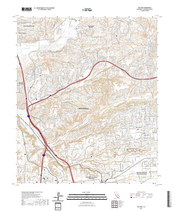 2021 Del Mar2021 Print · USGSModern coastal San Diego and its northern suburbs are shown here in the 2020s, highlighting the balance between dense development and canyon preserves. Researchers can locate local landmarks like Eden Gardens, the Carmel Valley Cem, and the University of California San Diego.
 - 2021 Map of La Jolla OE W, 2021 Print
 2021 La Jolla OE W2021 Print · USGSCoastal San Diego is captured here in the early 2020s, showing the modern layout of iconic seaside neighborhoods and beaches. Trace the development around Soledad Mtn or locate specific shore landmarks like La Jolla Cove and Bird Rock.
 - 2021 Map of Del Mar OE W, 2021 Print
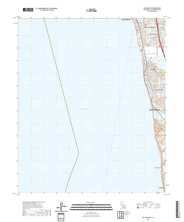 2021 Del Mar OE W2021 Print · USGSCoastal San Diego County is captured here in the early 2020s, showing the modern interface of suburban development and the Pacific shoreline. Researchers can trace street-level details through Solana Beach and Del Mar, or locate landmarks like Eden Gardens and the Los Penasquitos Marsh.
 - 2021 Map of Imperial Beach, 2021 Print
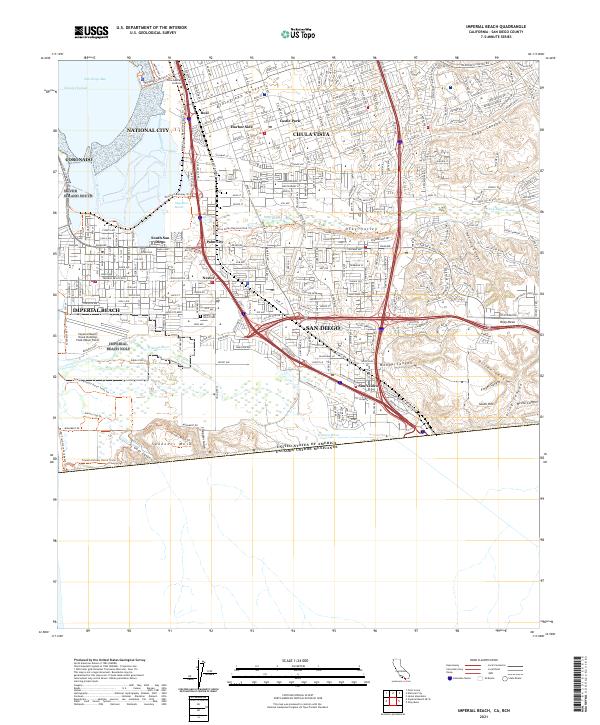 2021 Imperial Beach2021 Print · USGSThe California-Mexico border and the shores of San Diego Bay meet in this contemporary survey of the South Bay. Researchers can trace the modern layout of Nestor, Palm City, and San Ysidro or locate landmarks like Mount Olivet Cem and Border Field State Park.
 - 2021 Map of Point Loma, 2021 Print
 2021 Point Loma2021 Print · USGSSan Diego and Coronado are shown in detail during the early 2020s, revealing a landscape defined by naval installations and urban coastal life. Researchers can locate Fort Rosecrans National Cem, trace the Bayshore Bikeway Trl, or identify the campus of the California Western School of Law.
 - 2021 Map of Point Loma OE W, 2021 Print
 2021 Point Loma OE W2021 Print · USGSThe San Diego coastline comes into sharp focus in this recent survey of the Point Loma peninsula and its iconic surf-side neighborhoods. You can trace the residential streets of Ocean Beach and follow the Sunset Cliffs Coastal Trail past Osprey Point and Point Loma Nazarene University.
 - 2021 Map of La Jolla, 2021 Print
 2021 La Jolla2021 Print · USGSThe San Diego coast is mapped in detail during the early 2020s, showing the dense neighborhood grids from Pacific Beach to University Heights. Researchers can trace the heritage of Old Town San Diego, locate the Presidio Hill Cem, and study the layout of Fiesta Island.
 - 2021 Map of La Mesa, 2021 Print
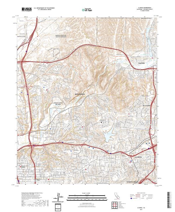 2021 La Mesa2021 Print · USGSThe San Diego interior and its neighboring cities are captured here in the contemporary era as suburban development meets the ridges of the Peninsular Ranges. Researchers can trace the boundaries of San Diego and La Mesa while locating landmarks like Murray Reservoir and San Diego State University.
 - 2021 Map of Poway, 2021 Print
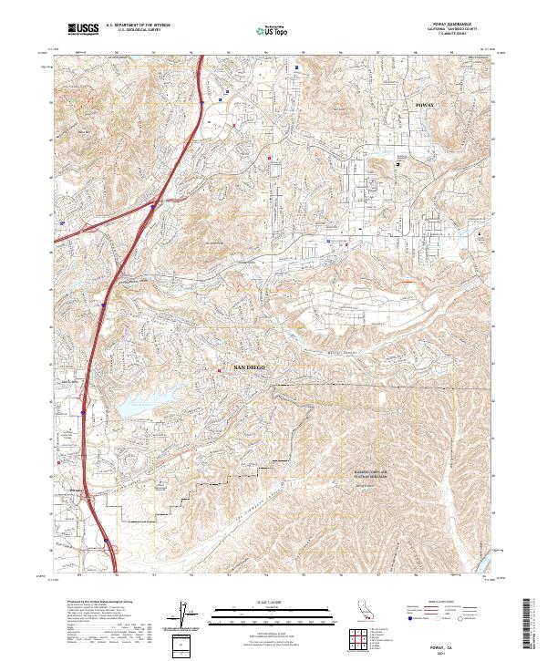 2021 Poway2021 Print · USGSPoway and the northern reaches of San Diego are shown here in the early twenty-first century as suburban growth follows the terrain of the inland canyons. Genealogists and local historians can locate the Smith Pioneer Cem, Dearborn Memorial Park, and prominent landmarks like Lake Miramar and Twin Peaks.
 - 2021 Map of Sombrero Peak, 2021 Print
 2021 Sombrero Peak2021 Print · USGSHigh-desert ridges and isolated mountain valleys define this part of San Diego County in the early 2020s. Researchers can locate the Manzanita Cem and trace old routes through Bow Willow Canyon and over the Tecate Divide.
 - 2021 Map of Tecate, 2021 Print
 2021 Tecate2021 Print · USGSThe San Diego borderlands near Tecate are shown here during the early 2020s, highlighting the mountainous terrain of the international boundary. Researchers can trace the San Diego City Conduit and locate regional junctions at Barrett Junction and Dulzura Summit.
 - 2021 Map of Agua Caliente Springs, 2021 Print
 2021 Agua Caliente Springs2021 Print · USGSCovers San Diego County, including United States, California, and other nearby areas
 - 2021 Map of Carrizo Mountain NE, 2021 Print
 2021 Carrizo Mountain NE2021 Print · USGSImperial County’s desert landscape is captured here as it appeared in 2021, showing the convergence of historic transit and natural landmarks. Historians can trace the Old Overland Stage Rte as it passes through the Fish Creek Mountains near the Wind Caves Trl.
 - 2021 Map of Arroyo Tapiado, 2021 Print
 2021 Arroyo Tapiado2021 Print · USGSArroyo Tapiado in the modern era still preserves the footprint of early California transit along its dry desert washes. Researchers can trace the Great Southern Overland Stage Rte as it passes historic water points like Palm Spring and Mesquite Oasis.
 - 2021 Map of Tierra del Sol, 2021 Print
 2021 Tierra del Sol2021 Print · USGSThe high-desert borderlands of San Diego County are captured here in the early 2020s, where the international line meets the Tecate Divide. Genealogists and researchers can trace local holdings and rural routes like Tierra Real Ln near Tierra del Sol and Lake Domingo.
 - 2021 Map of El Cajon Mountain, 2021 Print
 2021 El Cajon Mountain2021 Print · USGSSan Diego County in the early 2020s shows a landscape of protected forest and high-altitude reservoirs. Researchers can trace the trails and summits of Cleveland National Forest or locate landmarks like El Cajon Mtn, Barona, and Silverdome.
 - 2021 Map of Tule Springs, 2021 Print
 2021 Tule Springs2021 Print · USGSThe Cuyamaca Mountains and Cleveland National Forest are captured here during the 2020s, showing a landscape shaped by the San Diego River. Trace local landmarks like the Cedar Creek Falls and the historic Tule Springs or Pine Grove settlements.
 - 2021 Map of In-Ko-Pah Gorge OE S, 2021 Print
 2021 In-Ko-Pah Gorge OE S2021 Print · USGSHigh-desert borderlands are documented here in the early twenty-first century at the intersection of the international boundary and the California coast ranges. Researchers can trace the line of the United States of America Estados Unidos Mexicanos boundary near the summit of Blue Angels Peak.
 - 2021 Map of Carrizo Mountain, 2021 Print
 2021 Carrizo Mountain2021 Print · USGSThe arid borderlands of Imperial County are captured here in the early twenty-first century as the desert floor meets the Coyote Mountains. Researchers can trace remote desert routes like Sweeny Pass Rd and locate landmarks such as Emory Ranch Airport and Fossil Canyon.
 - 2021 Map of Barrett Lake, 2021 Print
 2021 Barrett Lake2021 Print · USGSSan Diego County's high country is captured here during the early twenty-first century, showing the intersection of water infrastructure and rural settlement. Researchers can trace the San Diego City Conduit and locate remote landmarks like Mother Grundy Peak or Round Potrero.
 - 2021 Map of Potrero, 2021 Print
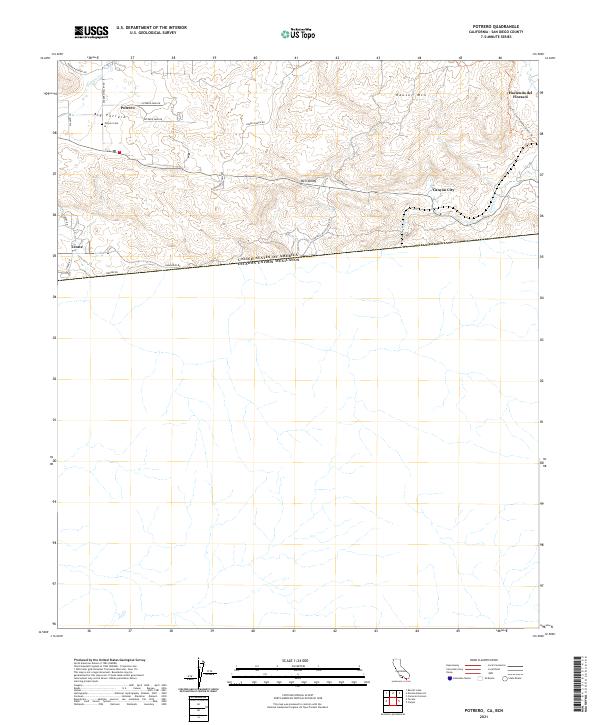 2021 Potrero2021 Print · USGSThe international border at Tecate and the valley communities of Potrero are documented in this 2021 study. Genealogists can locate the Potrero Cemetery while hikers trace the Pacific Crest National Scenic Trail through Bell Valley.
 - 2021 Map of Campo, 2021 Print
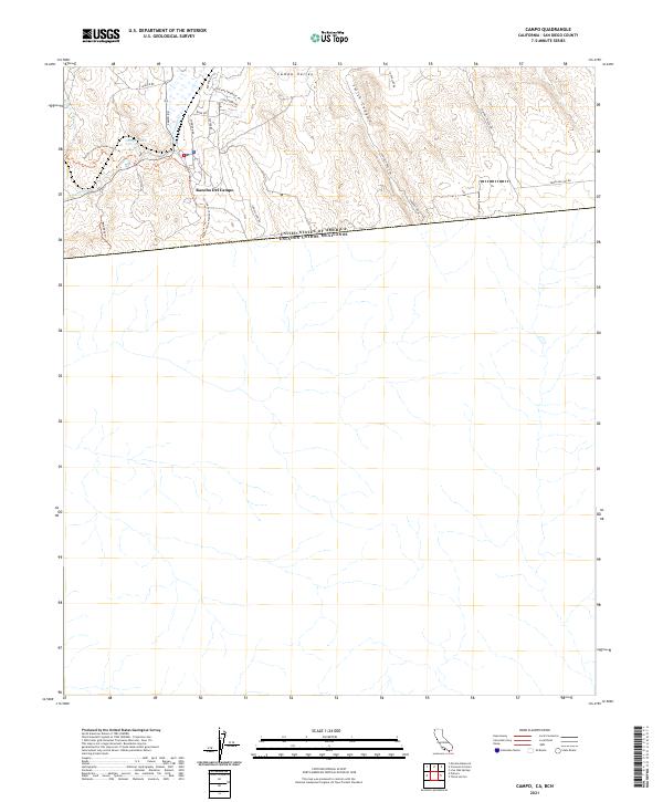 2021 Campo2021 Print · USGSThe international border territory of San Diego County comes into focus in the early 2020s. Trace the path of the Pacific Crest National Scenic Trl near Rancho Del Campo or follow the route of Hwy 94 through Campo Valley.
 - 2021 Map of Jacumba OE S, 2021 Print
 2021 Jacumba OE S2021 Print · USGSThe high-desert borderlands of San Diego County are captured in this recent survey, showcasing the area's unique geography along the international line. Researchers can trace the layout of Jacumba Hot Springs, the Jacumba Airport, and the slopes of Jacumba Peak.
Showing maps 1-25 of 99
Top cities of San Diego County
- San Diego historical maps
- Chula Vista historical maps
- Oceanside historical maps
- Escondido historical maps
- Carlsbad historical maps
- El Cajon historical maps
See more
Frequently asked questions
- What are the different types of historical maps available for San Diego County?
- What is the oldest map of San Diego County?
- Where can I purchase historical maps of San Diego County for my home or office?
- Where can I download high-res historical maps of San Diego County?
- Are there historical topographic maps available for San Diego County?
- Is there historical aerial imagery available for San Diego County?
- Where are historical maps of San Diego County sourced from?