1910s Maps of Tracy, California
Explore 3 historic maps of Tracy from the 1910s. These maps offer a rare glimpse into what life looked like during the 1910s — showing old roads, neighborhoods, homes, and landmarks that have changed or disappeared over time.
Whether you're researching your family's past, planning a metal detecting trip, or studying how Tracy's landscape evolved across the 1910s, these high-resolution maps are a powerful tool for exploring the history of this region.
- Focus on a specific era: All maps on this page are from the 1910s, giving you a focused view of this time period.
- See what’s changed: Compare century-old streets, trails, and buildings to today's modern landscape using overlays and satellite layers.
- Research with precision: Use these maps for genealogy, historical research, land use analysis, or educational projects.
- View, download, or print: Maps are fully viewable online in high resolution, and can be downloaded or printed for your own records.
Start exploring Tracy's history through authentic maps from the 1910s. This is your window into the past.
Tracy, CA maps
(3)- 1914 Map of Union Island
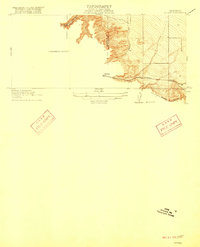
 1914 Union Island1914 Print · USGSThe San Joaquin Delta was a maze of reclaiming lands and new canals in the years before the Great War. Researchers can trace the early infrastructure of Union Island and find rural landmarks like the Naglee School and the Southern Pacific line.2 unique versions available
 - 1916 Map of Tracy
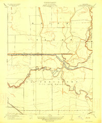
 1916 Tracy1916 Print · USGSIn the early twentieth century, the San Joaquin Valley floor was a complex web of competing rail lines centered on the growing town of Tracy. Researchers can trace the junction of the Southern Pacific and Western Pacific near early sites like Ellis and Jefferson School.3 unique versions available
 - 1916 Map of Midway
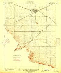
 1916 Midway1916 Print · USGSThe rail-and-ranching corridor of the Altamont pass comes to life in the years before the Great War. Genealogists and rail historians can trace the competing tracks of the Southern Pacific and Western Pacific as they converge near Midway.3 unique versions available
End of results
Showing maps 1-3 of 3
Top cities near Tracy
- Stockton historical maps
- Brentwood historical maps
- Mountain House historical maps
- Lathrop historical maps
- Discovery Bay historical maps
- Byron historical maps
Top neighborhoods of Tracy
- Ryland Junction historical maps
- Bridle Creek historical maps
- Ellis historical maps
- Sunset Park historical maps
- Victoria Greens historical maps
- Sienna Park historical maps
See more
Frequently asked questions
- What are the different types of historical maps available for Tracy?
- What is the oldest map of Tracy?
- Where can I purchase historical maps of Tracy for my home or office?
- Where can I download high-res historical maps of Tracy?
- Are there historical topographic maps available for Tracy?
- Is there historical aerial imagery available for Tracy?
- Where are historical maps of Tracy sourced from?