1950s Maps of Tracy, California
Explore 5 historic maps of Tracy from the 1950s. These maps offer a rare glimpse into what life looked like during the 1950s — showing old roads, neighborhoods, homes, and landmarks that have changed or disappeared over time.
Whether you're researching your family's past, planning a metal detecting trip, or studying how Tracy's landscape evolved across the 1950s, these high-resolution maps are a powerful tool for exploring the history of this region.
- Focus on a specific era: All maps on this page are from the 1950s, giving you a focused view of this time period.
- See what’s changed: Compare century-old streets, trails, and buildings to today's modern landscape using overlays and satellite layers.
- Research with precision: Use these maps for genealogy, historical research, land use analysis, or educational projects.
- View, download, or print: Maps are fully viewable online in high resolution, and can be downloaded or printed for your own records.
Start exploring Tracy's history through authentic maps from the 1950s. This is your window into the past.
Tracy, CA maps
(5)- 1952 Map of Union Island, 1953 Print
 1952 Union Island1953 Print · USGSThe San Joaquin Delta of the early fifties is mapped here as a productive landscape of reclaimed land and sloughs. Researchers can trace the legacy of local education and industry through the David Bixler Sch and the Sugar Refinery.4 unique versions available
 - 1952 Map of Stockton, 1959 Print
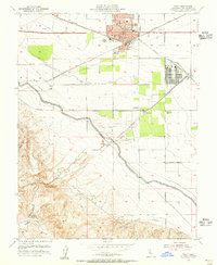
 1952 Stockton1959 Print · USGSThe San Joaquin Delta during the early fifties shows a thriving river economy and growing urban centers at the heart of the Central Valley. Genealogists can trace rural life through numerous one-room schools like David Bixler School or find industrial roots at the Sugar Refinery and Sharpe General Depot.2 unique versions available
 - 1953 Map of Midway, 1955 Print
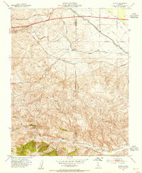 1953 Midway1955 Print · USGSAltamont Pass and the Diablo Range are captured here during a period of major infrastructure growth in the early fifties. Genealogists and industrial historians can trace the foundations of former boomtowns like Tesla (Site) and Carnegie (Site) alongside the massive Delta-Mendota Canal.6 unique versions available
 - 1954 Map of Tracy, 1955 Print
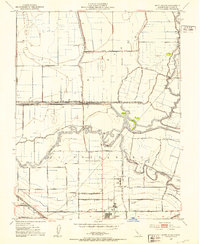
 1954 Tracy1955 Print · USGSMid-century Tracy emerges as a vital California rail and water hub just as the region's massive canal projects were being completed. Researchers can locate vanished infrastructure and landmarks like the Sharpe General Depot, Carbona, and the Manganese Mill in Corral Hollow.6 unique versions available
 - 1956 Map of San Jose
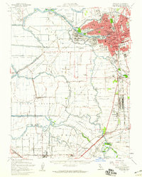
 1956 San Jose1956 Print · USGSCentral California in the mid-fifties reveals the transition from sprawling orchards to growing urban hubs like San Jose and Stockton. Genealogists and historians can trace the rail-era landscape of the Mother Lode through Chinese Camp and Tuttletown, or follow the water through the Joaquin River and Calaveras Reservoir.
End of results
Showing maps 1-5 of 5
Top cities near Tracy
- Stockton historical maps
- Brentwood historical maps
- Mountain House historical maps
- Lathrop historical maps
- Discovery Bay historical maps
- Byron historical maps
Top neighborhoods of Tracy
- Ryland Junction historical maps
- Bridle Creek historical maps
- Ellis historical maps
- Sunset Park historical maps
- Victoria Greens historical maps
- Sienna Park historical maps
See more
Frequently asked questions
- What are the different types of historical maps available for Tracy?
- What is the oldest map of Tracy?
- Where can I purchase historical maps of Tracy for my home or office?
- Where can I download high-res historical maps of Tracy?
- Are there historical topographic maps available for Tracy?
- Is there historical aerial imagery available for Tracy?
- Where are historical maps of Tracy sourced from?