Old Maps of Adelaida, California for Metal Detecting
Plan your next treasure hunt with 16 historic maps of Adelaida. Find old homesites, ghost towns, trails, and gathering spots that may be lost to time — perfect for identifying promising metal detecting locations.
- Locate forgotten sites: Uncover places like long-lost settlements, abandoned rail lines, or gathering spots.
- Plan better hunts: Use map overlays combined with LiDAR or satellite views to narrow in on historically rich areas.
- Made for detectorists: Thousands of hobbyists use these maps to discover relics, coins, and hidden history.
Use these historic maps to boost your research and find new opportunities beneath the surface of Adelaida.
Adelaida, CA maps
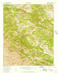
(16)- 1919 Map of Adelaida
 1919 Adelaida1919 Print · USGSSan Luis Obispo County’s interior ridges are mapped here shortly after the Great War, showing a landscape of small ranches and rural schools. Genealogists can trace family connections to landmarks like Adelaida, the German Church, and the Williams Ranch.2 unique versions available
 - 1932 Map of Adelaida
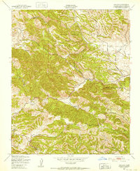
 1932 Adelaida1932 Print · USGSSan Luis Obispo County’s interior highlands appear here between the world wars, showing a landscape of remote mountain ranches and creek-side settlements. Genealogists can trace early homesteads near the German Church or locate rural schoolhouses like Lincoln School and Asuncion School.2 unique versions available
 - 1942 Map of Adelaida
 1942 Adelaida1942 Print · USGSThe Santa Lucia Range was still a rugged frontier of ranching and quicksilver mining in the early 1940s. Genealogists can trace family holdings like Kentucky Ranch and old rural schoolhouses including Summit School and Asuncion School.
 - 1947 Map of San Luis Obispo, 1948 Print
 1947 San Luis Obispo1948 Print · USGSCoastal California at the dawn of the Cold War reveals a landscape of massive military reservations and quiet seaside towns. Genealogists and researchers can trace the Southern Pacific rail line, old mining sites like Los Burros Mine, and local landmarks from Point Buchon to the Carrizo Plain.
 - 1947 Map of Adelaida, 1957 Print
 1947 Adelaida1957 Print · USGSThe Santa Lucia Range of San Luis Obispo County was a landscape of remote mines and scattered ranching communities shortly after the war. Local historians can trace early community hubs like Adelaida, the Klau Mine, and several rural schoolhouses such as Lincoln Sch.2 unique versions available
 - 1948 Map of San Luis Obispo
 1948 San Luis Obispo1948 Print · USGSCentral Coast life in the late 1940s is centered on the Southern Pacific rail line and expanding military bases. Genealogists can trace early rural life through Union School and local operations like the Klau Mine or Buena Vista Mine.
 - 1948 Map of Adelaida, 1952 Print
 1948 Adelaida1952 Print · USGSSan Luis Obispo County’s rugged ranching interior is captured here in the late forties, just after the war years. Local historians can trace the foundations of the Adelaida community, locating the Lincoln Sch, Adelaida Cem, and the White Ranch homestead.8 unique versions available
 - 1956 Map of San Luis Obispo, 1963 Print
 1956 San Luis Obispo1963 Print · USGSCentral California coastal and valley life unfolds in the mid-fifties, from the shoreline of Pismo Beach to the arid Carrizo Plain. Trace early travel routes along the Southern Pacific RR or locate family sites near the Templeton Cemetery and Paso Robles County Cemetery.5 unique versions available
 - 1957 Map of San Luis Obispo
 1957 San Luis Obispo1957 Print · USGSCoastal California in the late fifties is defined by the steep Santa Lucia Range and the rail-connected hub of San Luis Obispo. Genealogists and researchers can trace rural life via Union School, the Southern Pacific line, and old sites like the Polar Star Mine.
 - 1958 Map of San Luis Obispo
 1958 San Luis Obispo1958 Print · USGSThe Central Coast in the late fifties reveals a landscape of ranching and early tourism before the massive expansion of the modern era. Trace the path of the Southern Pacific through Atascadero or locate family roots in coastal towns like Cayucos and Cambria.
 - 1961 Map of Adelaida, 1968 Print
 1961 Adelaida1968 Print · USGSCoastal California ranching and mining culture are preserved here in the early sixties as the Nacimiento Reservoir area developed. Researchers can locate local landmarks like the Adelaida Sch, the Klau Mine, and several historic family holdings including Kentucky Ranch.
 - 1989 Map of Paso Robles
 1989 Paso Robles1989 Print · USGSCoastal mountains and the Salinas River valley meet in the late eighties as this region balances military installations and agriculture. Genealogists and historians can trace the Southern Pacific line through Paso Robles and Templeton or locate the Klau Mine and San Miguel.
 - 2012 Map of Adelaida, 2012 Print
 2012 Adelaida2012 Print · USGSCovers Adelaida, including Lake Nacimiento, San Luis Obispo County, and other nearby areas
 - 2015 Map of Adelaida, 2015 Print
 2015 Adelaida2015 Print · USGSCovers Adelaida, including Lake Nacimiento, San Luis Obispo County, and other nearby areas
 - 2018 Map of Adelaida, 2018 Print
 2018 Adelaida2018 Print · USGSCovers Adelaida, including Lake Nacimiento, San Luis Obispo County, and other nearby areas
 - 2021 Map of Adelaida, 2021 Print
 2021 Adelaida2021 Print · USGSThe ranching and vineyard country of San Luis Obispo County is captured here in the early 2020s. Researchers can locate family landmarks like the Adelaida Cem, the Halter Ranch Airport, and the winding course of San Marcos Cr.
End of results
Showing maps 1-16 of 16
Top cities near Adelaida
- Atascadero historical maps
- Paso Robles historical maps
- Cambria historical maps
- San Miguel historical maps
Frequently asked questions
- What are the different types of historical maps available for Adelaida?
- What is the oldest map of Adelaida?
- Where can I purchase historical maps of Adelaida for my home or office?
- Where can I download high-res historical maps of Adelaida?
- Are there historical topographic maps available for Adelaida?
- Is there historical aerial imagery available for Adelaida?
- Where are historical maps of Adelaida sourced from?