1900s (20th Century) Maps of Beegum, California
Explore 5 historic maps of Beegum from the 1900s (20th Century). These maps offer a rare glimpse into what life looked like during the 1900s — showing old roads, neighborhoods, homes, and landmarks that have changed or disappeared over time.
Whether you're researching your family's past, planning a metal detecting trip, or studying how Beegum's landscape evolved across the 1900s, these high-resolution maps are a powerful tool for exploring the history of this region.
- Focus on a specific era: All maps on this page are from the 1900s, giving you a focused view of this time period.
- See what’s changed: Compare century-old streets, trails, and buildings to today's modern landscape using overlays and satellite layers.
- Research with precision: Use these maps for genealogy, historical research, land use analysis, or educational projects.
- View, download, or print: Maps are fully viewable online in high resolution, and can be downloaded or printed for your own records.
Start exploring Beegum's history through authentic maps from the 1900s. This is your window into the past.
Beegum, CA maps
(5)- 1951 Map of Chanchelulla Peak, 1953 Print
 1951 Chanchelulla Peak1953 Print · USGSNorthern California's interior mountains at the midpoint of the century reveal a landscape of isolated forest stations and family ranches. Researchers can locate the Midas Mine and trace early road networks connecting Platina with the Harrison Gulch Ranger Station and Deer Lick Springs.5 unique versions available
 - 1958 Map of Redding
 1958 Redding1958 Print · USGSNorthern California's valley and mountain landscapes are captured in the late fifties, showing the region as new reservoirs reshaped the river systems. Genealogists and historians can trace rail-side towns like Cottonwood, the military presence at Red Bluff Air Force Station, and mountain outposts like Weaverville.5 unique versions available
 - 1979 Map of Red Bluff
 1979 Red Bluff1979 Print · USGSTehama and Shasta counties come alive in the late seventies as the agricultural heart of the northern valley meets the high wilderness. Genealogists and local historians can trace the rail-and-river corridor from Red Bluff to Los Molinos, finding sites like Balls Ferry and the Southern Pacific line.3 unique versions available
 - 1981 Map of Beegum
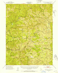
 1981 Beegum1981 Print · USGSThe remote borderlands of Tehama, Shasta, and Trinity counties are captured in the early eighties as a landscape of isolated ranching and federal forestry. Researchers can trace family-named sites like Williams Ranch, find the local Cem, or locate the Chrome Mine (Site).
 - 1998 Map of Beegum, 2003 Print
 1998 Beegum2003 Print · USGSShasta and Tehama counties appear here in the late nineties, showing a landscape defined by rugged national forest boundaries and isolated ranching outposts. Researchers can trace historic family locations like Williams Ranch and the Patty Mocus Butte Lookout.
End of results
Showing maps 1-5 of 5
Frequently asked questions
- What are the different types of historical maps available for Beegum?
- What is the oldest map of Beegum?
- Where can I purchase historical maps of Beegum for my home or office?
- Where can I download high-res historical maps of Beegum?
- Are there historical topographic maps available for Beegum?
- Is there historical aerial imagery available for Beegum?
- Where are historical maps of Beegum sourced from?