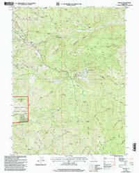
1998 Map of Beegum
USGS Topo · Published 2003About this map
Beegum lies at the boundary of Shasta and Tehama counties, where the high ridges of the Shasta and Trinity National Forests meet. This late-twentieth-century revision reveals a landscape of remote ranching outposts and strategic fire observation, anchored by the Patty Mocus Butte Lookout (CDF) in the west. The terrain is deeply dissected by a network of waterways including Beegum Creek, Cottonwood Creek, and the West Fork Beegum Creek. Numerous family-named sites such as Williams Ranch, Stiell Ranch, and Ball Ranch highlight the enduring agricultural footprint in this mountain region. Industrial and utility developments are present through the complex of Sewage Disposal Ponds near Wild Horse Mesa and a long-distance Pipeline cutting across the central hills, while scattered Prospects indicate earlier mineral exploration near the southern forest boundary.
Find a feature on this map
55 named features on this map. Tap any name to fly to it.
Don’t see what you’re looking for? This feature index may not catch every label — zoom into the map to look around manually.
Map Details
Editions of this 1998 Beegum Map
This is the sole edition of this map. No revisions or reprints were ever made.
Other maps of this area

1890 · Red Bluff
USGS Topo · 1:250,000

1894 · Red Bluff
USGS Topo · 1:250,000

1949 · Colyear Springs
USGS Topo · 1:62,500

1951 · Chanchelulla Peak
USGS Topo · 1:62,500

1952 · Ono
USGS Topo · 1:62,500

1954 · Yolla Bolly
USGS Topo · 1:62,500

1957 · Colyear Springs
USGS Topo · 1:62,500

1958 · Redding
USGS Topo · 1:250,000
1967 · Cold Fork
USGS Topo · 1:24,000
1979 · Red Bluff
USGS Topo · 1:100,000