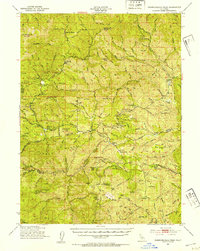
1951 Map of Chanchelulla Peak
USGS Topo · Published 1953About this map
The intersection of Trinity, Shasta, and Tehama counties defines this high-altitude landscape within the Trinity National Forest. The 1951 field check captures a network of remote outposts and family cattle operations, including the Harrison Gulch Ranger Station and the Deer Lick Guard Station. These administrative points supported the management of the complex drainages feeding into the Middle Fork Cottonwood Creek and the South Fork Cottonwood Creek.
Find a feature on this map
94 named features on this map. Tap any name to fly to it.
Don’t see what you’re looking for? This feature index may not catch every label — zoom into the map to look around manually.
Map Details
Editions of this 1951 Chanchelulla Peak Map
5 editions found
Historical Maps of Knob Through Time
286 maps found

1886 Lassen Peak
Shasta County, CA

1892 Lassen Peak
Shasta County, CA

1894 Lassen Peak
Shasta County, CA

1932 Olinda
Shasta County, CA

1935 Olinda
Shasta County, CA

1946 Lamoine
Shasta County, CA

1949 Bollibokka Mtn
Shasta County, CA

1950 Schell Mtn
Shasta County, CA

1951 Chanchelulla Peak
Shasta County, CA

1952 Schell Mtn.
Shasta County, CA

1954 Shoeinhorse Mountain
Shasta County, CA

1956 Manzanita Lake
Shasta County, CA

1956 Shasta Dam
Shasta County, CA

1957 Bollibokka Mtn
Shasta County, CA

1957 Enterprise
Shasta County, CA

1957 Jellico
Shasta County, CA

1957 Lamoine
Shasta County, CA

1957 Project City
Shasta County, CA

1957 Prospect Peak
Shasta County, CA

1961 Pondosa
Shasta County, CA

1964 Olinda
Shasta County, CA

1965 Balls Ferry
Shasta County, CA

1965 Tuscan Buttes NE
Shasta County, CA

1967 Schell Mtn
Shasta County, CA

1969 Lamoine
Shasta County, CA

1978 Shasta Bally
Shasta County, CA

1979 Whiskeytown
Shasta County, CA

1981 Chanchelulla Peak
Shasta County, CA

1982 Damnation Peak
Shasta County, CA

1982 Schell Mtn
Shasta County, CA

1985 Clough Gulch
Shasta County, CA

1985 Hagaman Gulch
Shasta County, CA

1985 Inwood
Shasta County, CA

1985 Jacks Backbone
Shasta County, CA

1985 Manzanita Lake
Shasta County, CA

1985 Miller Mountain
Shasta County, CA

1985 Thousand Lakes Valley
Shasta County, CA

1985 West Prospect Peak
Shasta County, CA

1986 Chicken Hawk Hill
Shasta County, CA

1986 Shoeinhorse Mountain
Shasta County, CA

1986 Tombstone Mtn
Shasta County, CA

1986 Viola
Shasta County, CA

1986 Yellowjacket Mtn.
Shasta County, CA

1990 Bohemotash Mountain
Shasta County, CA

1990 Bollibokka Mountain
Shasta County, CA

1990 Burney Falls
Shasta County, CA

1990 Burney Mountain East
Shasta County, CA

1990 Burney Mountain West
Shasta County, CA

1990 Chalk Mountain
Shasta County, CA

1990 Dana
Shasta County, CA

1990 Devils Rock
Shasta County, CA

1990 Goose Gap
Shasta County, CA

1990 Hanland Peak
Shasta County, CA

1990 Hatchet Mountain Pass
Shasta County, CA

1990 Hogback Ridge
Shasta County, CA

1990 Lamoine
Shasta County, CA

1990 Minnesota Mountain
Shasta County, CA

1990 Murken Bench
Shasta County, CA

1990 O'Brien
Shasta County, CA

1990 Roaring Creek
Shasta County, CA

1990 Skunk Ridge
Shasta County, CA

1990 Timbered Crater
Shasta County, CA

1995 Burney Falls
Shasta County, CA

1995 Burney Mountain East
Shasta County, CA

1995 Burney Mountain West
Shasta County, CA

1995 Dana
Shasta County, CA

1995 Hatchet Mountain Pass
Shasta County, CA

1995 Hogback Ridge
Shasta County, CA

1995 Jacks Backbone
Shasta County, CA

1995 Manzanita Lake
Shasta County, CA

1995 Miller Mountain
Shasta County, CA

1995 Murken Bench
Shasta County, CA

1995 Thousand Lakes Valley
Shasta County, CA

1995 Timbered Crater
Shasta County, CA

1995 Viola
Shasta County, CA

1995 West Prospect Peak
Shasta County, CA

1998 Bohemotash Mountain
Shasta County, CA

1998 Bollibokka Mountain
Shasta County, CA

1998 Chalk Mountain
Shasta County, CA

1998 Chicken Hawk Hill
Shasta County, CA

1998 City of Shasta Lake
Shasta County, CA

1998 Damnation Peak
Shasta County, CA

1998 Devils Rock
Shasta County, CA

1998 Goose Gap
Shasta County, CA

1998 Hanland Peak
Shasta County, CA

1998 Lamoine
Shasta County, CA

1998 Minnesota Mountain
Shasta County, CA

1998 O'Brien
Shasta County, CA

1998 Roaring Creek
Shasta County, CA

1998 Schell Mountain
Shasta County, CA

1998 Shasta Dam
Shasta County, CA

1998 Shoeinhorse Mountain
Shasta County, CA

1998 Skunk Ridge
Shasta County, CA

1998 Tombstone Mountain
Shasta County, CA

1998 Whiskeytown
Shasta County, CA

1998 Yellowjacket Mountain
Shasta County, CA

2012 Arbuckle Mountain
Shasta County, CA

2012 Balls Ferry
Shasta County, CA

2012 Bohemotash Mountain
Shasta County, CA

2012 Bollibokka Mountain
Shasta County, CA

2012 Burney Falls
Shasta County, CA

2012 Burney Mountain East
Shasta County, CA

2012 Burney Mountain West
Shasta County, CA

2012 Chalk Mountain
Shasta County, CA

2012 Chicken Hawk Hill
Shasta County, CA

2012 City of Shasta Lake
Shasta County, CA

2012 Clough Gulch
Shasta County, CA

2012 Damnation Peak
Shasta County, CA

2012 Dana
Shasta County, CA

2012 Devils Rock
Shasta County, CA

2012 Enterprise
Shasta County, CA

2012 Goose Gap
Shasta County, CA

2012 Hagaman Gulch
Shasta County, CA

2012 Hanland Peak
Shasta County, CA

2012 Hatchet Mountain Pass
Shasta County, CA

2012 Hogback Ridge
Shasta County, CA

2012 Inwood
Shasta County, CA

2012 Jacks Backbone
Shasta County, CA

2012 Lamoine
Shasta County, CA

2012 Manzanita Lake
Shasta County, CA

2012 Miller Mountain
Shasta County, CA

2012 Minnesota Mountain
Shasta County, CA

2012 Murken Bench
Shasta County, CA

2012 O'Brien
Shasta County, CA

2012 Olinda
Shasta County, CA

2012 Roaring Creek
Shasta County, CA

2012 Schell Mountain
Shasta County, CA

2012 Shasta Bally
Shasta County, CA

2012 Shasta Dam
Shasta County, CA

2012 Shoeinhorse Mountain
Shasta County, CA

2012 Skunk Ridge
Shasta County, CA

2012 Tar Bully
Shasta County, CA

2012 Thousand Lakes Valley
Shasta County, CA

2012 Timbered Crater
Shasta County, CA

2012 Tombstone Mountain
Shasta County, CA

2012 Tuscan Buttes NE
Shasta County, CA

2012 Viola
Shasta County, CA

2012 West Prospect Peak
Shasta County, CA

2012 Whiskeytown
Shasta County, CA

2012 Yellowjacket Mountain
Shasta County, CA

2015 Arbuckle Mountain
Shasta County, CA

2015 Balls Ferry
Shasta County, CA

2015 Bohemotash Mountain
Shasta County, CA

2015 Bollibokka Mountain
Shasta County, CA

2015 Burney Falls
Shasta County, CA

2015 Burney Mountain East
Shasta County, CA

2015 Burney Mountain West
Shasta County, CA

2015 Chalk Mountain
Shasta County, CA

2015 Chicken Hawk Hill
Shasta County, CA

2015 City of Shasta Lake
Shasta County, CA

2015 Clough Gulch
Shasta County, CA

2015 Damnation Peak
Shasta County, CA

2015 Dana
Shasta County, CA

2015 Devils Rock
Shasta County, CA

2015 Enterprise
Shasta County, CA

2015 Goose Gap
Shasta County, CA

2015 Hagaman Gulch
Shasta County, CA

2015 Hanland Peak
Shasta County, CA

2015 Hatchet Mountain Pass
Shasta County, CA

2015 Hogback Ridge
Shasta County, CA

2015 Inwood
Shasta County, CA

2015 Jacks Backbone
Shasta County, CA

2015 Lamoine
Shasta County, CA

2015 Manzanita Lake
Shasta County, CA

2015 Miller Mountain
Shasta County, CA

2015 Minnesota Mountain
Shasta County, CA

2015 Murken Bench
Shasta County, CA

2015 O'Brien
Shasta County, CA

2015 Olinda
Shasta County, CA

2015 Roaring Creek
Shasta County, CA

2015 Schell Mountain
Shasta County, CA

2015 Shasta Bally
Shasta County, CA

2015 Shasta Dam
Shasta County, CA

2015 Shoeinhorse Mountain
Shasta County, CA

2015 Skunk Ridge
Shasta County, CA

2015 Tar Bully
Shasta County, CA

2015 Thousand Lakes Valley
Shasta County, CA

2015 Timbered Crater
Shasta County, CA

2015 Tombstone Mountain
Shasta County, CA

2015 Tuscan Buttes NE
Shasta County, CA

2015 Viola
Shasta County, CA

2015 West Prospect Peak
Shasta County, CA

2015 Whiskeytown
Shasta County, CA

2015 Yellowjacket Mountain
Shasta County, CA

2018 Arbuckle Mountain
Shasta County, CA

2018 Balls Ferry
Shasta County, CA

2018 Bohemotash Mountain
Shasta County, CA

2018 Bollibokka Mountain
Shasta County, CA

2018 Burney Falls
Shasta County, CA

2018 Burney Mountain East
Shasta County, CA

2018 Burney Mountain West
Shasta County, CA

2018 Chalk Mountain
Shasta County, CA

2018 Chicken Hawk Hill
Shasta County, CA

2018 City of Shasta Lake
Shasta County, CA

2018 Clough Gulch
Shasta County, CA

2018 Damnation Peak
Shasta County, CA

2018 Dana
Shasta County, CA

2018 Devils Rock
Shasta County, CA

2018 Enterprise
Shasta County, CA

2018 Goose Gap
Shasta County, CA

2018 Hagaman Gulch
Shasta County, CA

2018 Hanland Peak
Shasta County, CA

2018 Hatchet Mountain Pass
Shasta County, CA

2018 Hogback Ridge
Shasta County, CA

2018 Inwood
Shasta County, CA

2018 Jacks Backbone
Shasta County, CA

2018 Lamoine
Shasta County, CA

2018 Manzanita Lake
Shasta County, CA

2018 Miller Mountain
Shasta County, CA

2018 Minnesota Mountain
Shasta County, CA

2018 Murken Bench
Shasta County, CA

2018 O'Brien
Shasta County, CA

2018 Olinda
Shasta County, CA

2018 Roaring Creek
Shasta County, CA

2018 Schell Mountain
Shasta County, CA

2018 Shasta Bally
Shasta County, CA

2018 Shasta Dam
Shasta County, CA

2018 Shoeinhorse Mountain
Shasta County, CA

2018 Skunk Ridge
Shasta County, CA

2018 Tar Bully
Shasta County, CA

2018 Thousand Lakes Valley
Shasta County, CA

2018 Timbered Crater
Shasta County, CA

2018 Tombstone Mountain
Shasta County, CA

2018 Tuscan Buttes NE
Shasta County, CA

2018 Viola
Shasta County, CA

2018 West Prospect Peak
Shasta County, CA

2018 Whiskeytown
Shasta County, CA

2018 Yellowjacket Mountain
Shasta County, CA

2021 Balls Ferry
Shasta County, CA

2021 Bollibokka Mountain
Shasta County, CA

2021 Burney Mountain East
Shasta County, CA

2021 Clough Gulch
Shasta County, CA

2021 Devils Rock
Shasta County, CA

2021 Hatchet Mountain Pass
Shasta County, CA

2021 Hogback Ridge
Shasta County, CA

2021 Manzanita Lake
Shasta County, CA

2021 Minnesota Mountain
Shasta County, CA

2021 Murken Bench
Shasta County, CA

2021 Olinda
Shasta County, CA

2021 Shasta Dam
Shasta County, CA

2021 Shoeinhorse Mountain
Shasta County, CA

2021 Skunk Ridge
Shasta County, CA

2021 Tar Bully
Shasta County, CA

2021 Thousand Lakes Valley
Shasta County, CA

2021 Viola
Shasta County, CA

2021 West Prospect Peak
Shasta County, CA

2021 Whiskeytown
Shasta County, CA

2021 Yellowjacket Mountain
Shasta County, CA

2022 Arbuckle Mountain
Shasta County, CA

2022 Bohemotash Mountain
Shasta County, CA

2022 Burney Falls
Shasta County, CA

2022 Burney Mountain West
Shasta County, CA

2022 Chalk Mountain
Shasta County, CA

2022 Chicken Hawk Hill
Shasta County, CA

2022 City of Shasta Lake
Shasta County, CA

2022 Damnation Peak
Shasta County, CA

2022 Dana
Shasta County, CA

2022 Enterprise
Shasta County, CA

2022 Goose Gap
Shasta County, CA

2022 Hagaman Gulch
Shasta County, CA

2022 Hanland Peak
Shasta County, CA

2022 Inwood
Shasta County, CA

2022 Jacks Backbone
Shasta County, CA

2022 Lamoine
Shasta County, CA

2022 Miller Mountain
Shasta County, CA

2022 O'Brien
Shasta County, CA

2022 Roaring Creek
Shasta County, CA

2022 Schell Mountain
Shasta County, CA

2022 Shasta Bally
Shasta County, CA

2022 Timbered Crater
Shasta County, CA

2022 Tombstone Mountain
Shasta County, CA

2022 Tuscan Buttes NE
Shasta County, CA

2023 Bohemotash Mountain
Shasta County, CA

2023 Bollibokka Mountain
Shasta County, CA

2023 City of Shasta Lake
Shasta County, CA

2023 Devils Rock
Shasta County, CA

2023 Enterprise
Shasta County, CA

2023 Goose Gap
Shasta County, CA

2023 Hagaman Gulch
Shasta County, CA

2023 Minnesota Mountain
Shasta County, CA

2023 Schell Mountain
Shasta County, CA

2023 Shasta Dam
Shasta County, CA

2023 Shoeinhorse Mountain
Shasta County, CA

2023 Skunk Ridge
Shasta County, CA

2023 Whiskeytown
Shasta County, CA

2023 Yellowjacket Mountain
Shasta County, CA