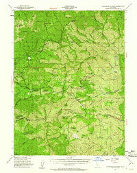
1951 Map of Chanchelulla Peak
USGS Topo · Published 1961About this map
Trinity National Forest dominates this mid-century landscape where the borders of Trinity, Shasta, and Tehama counties meet. The high point of Chanchelulla Pk watches over a terrain defined by narrow gulches and family-named landholdings. A legacy of early extraction and resource management is evident at the Midas Mine and the Harrison Gulch Ranger Sta, while social centers appear at locations like Deer Lick Springs and a local Cem. The settlement pattern is characterized by scattered operations such as Williams Ranch, Griswold Ranch, and Bland Ranch, which suggest a remote ranching economy dependent on the drainages of Beegum Creek and Cottonwood Creek. This map captures the area as it was surveyed in 1951, documenting the complex network of trails and unimproved roads connecting these high-country outposts before modern infrastructure altered the reach of the Trinity wilderness.
Find a feature on this map
116 named features on this map. Tap any name to fly to it.
Don’t see what you’re looking for? This feature index may not catch every label — zoom into the map to look around manually.
Map Details
Editions of this 1951 Chanchelulla Peak Map
5 editions found

Other maps of this area

1890 · Red Bluff
USGS Topo · 1:250,000

1894 · Red Bluff
USGS Topo · 1:250,000

1909 · Big Bar
USGS Topo · 1:96,000

1913 · Weaverville
USGS Topo · 1:125,000

1915 · Big Bar and Vicinity
USGS Topo · 1:250,000

1931 · Hoaglin
USGS Topo · 1:96,000

1935 · Hoaglin
USGS Topo · 1:125,000

1944 · French Gulch
USGS Topo · 1:62,500

1948 · French Gulch
USGS Topo · 1:62,500

1949 · Colyear Springs
USGS Topo · 1:62,500