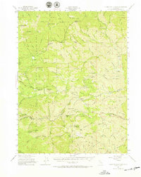
1951 Map of Chanchelulla Peak
USGS Topo · Published 1966About this map
Platina serves as a small waypoint in this high-elevation landscape where the boundaries of Trinity, Shasta, and Tehama counties converge. The 1951 field check reveals a region defined by remote administrative outposts and private holdings, including the Harrison Gulch Ranger Sta and the Deer Lick Guard Sta. Ranching footprints are scattered throughout the drainages, with established sites like Williams Ranch, Braden Ranch, and Griswold Ranch marking the habitable pockets of the terrain.
Find a feature on this map
116 named features on this map. Tap any name to fly to it.
Don’t see what you’re looking for? This feature index may not catch every label — zoom into the map to look around manually.
Map Details
Editions of this 1951 Chanchelulla Peak Map
5 editions found

Other maps of this area

1890 · Red Bluff
USGS Topo · 1:250,000

1894 · Red Bluff
USGS Topo · 1:250,000

1909 · Big Bar
USGS Topo · 1:96,000

1913 · Weaverville
USGS Topo · 1:125,000

1915 · Big Bar and Vicinity
USGS Topo · 1:250,000

1931 · Hoaglin
USGS Topo · 1:96,000

1935 · Hoaglin
USGS Topo · 1:125,000

1944 · French Gulch
USGS Topo · 1:62,500

1948 · French Gulch
USGS Topo · 1:62,500

1949 · Colyear Springs
USGS Topo · 1:62,500