Old Maps of Lakehead-Lakeshore, California for Academic Research
Study the evolution of Lakehead-Lakeshore with 27 high-resolution historic maps. Whether you're teaching, researching, or modeling changes in land use, these maps provide essential visual documentation of urban, environmental, and geographic change.
- Analyze long-term change: Track patterns in development, transportation, and natural features.
- Ideal for environmental or urban studies: Support academic projects with primary historical map data.
- Use in the classroom or lab: Educators and researchers rely on these maps to bring historical context to life.
These maps are a powerful tool for teaching, research, and visualizing how Lakehead-Lakeshore has changed over the decades.
Lakehead-Lakeshore, CA maps
(27)- 1890 Map of Red Bluff
 1890 Red Bluff1890 Print · USGSNorthern California in the late nineteenth century was a hub of river-and-rail activity where the Central Pacific Railroad met the rugged Klamath Mountains. Researchers can trace old ferry crossings like Ball's Ferry, locate the U.S. Fishery, or find early mining camps and stations such as Minersville and Buck Horn Station.
 - 1894 Map of Red Bluff, 1896 Print
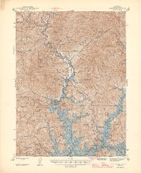
 1894 Red Bluff1896 Print · USGSNorthern California's mining and river-trading frontier comes alive in this survey of the late nineteenth century. Genealogists and historians can trace the growth of rail hubs like Redding or locate early river crossings and industrial sites such as Jelley's Ferry and the Copper Mine.6 unique versions available
 - 1901 Map of Redding
 1901 Redding1901 Print · USGSShasta County's northern canyon and mining districts come into focus at the dawn of the twentieth century. Researchers can trace the original rail stops at Kennett and Keswick or locate early industrial sites like the Bully Hill Mine and Baird Fish Hatchery.7 unique versions available
 - 1946 Map of Lamoine
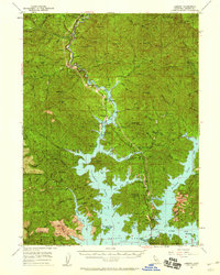
 1946 Lamoine1946 Print · USGSShasta County mountain communities and early mining sites are captured here as the new reservoir begins to fill the canyons. Genealogists and researchers can locate the Smithson Sch, the Shasta Iron Mine, and post offices at Bayles P O and Loftus P O.2 unique versions available
 - 1957 Map of Lamoine, 1959 Print
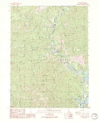
 1957 Lamoine1959 Print · USGSIn the Shasta National Forest during the late fifties, the landscape was being reshaped by the rising waters of the new reservoir. Researchers can trace the path of the Southern Pacific and U S 99 past Lamoine, Delta, and the Clipper Mine.2 unique versions available
 - 1958 Map of Redding
 1958 Redding1958 Print · USGSNorthern California's valley and mountain landscapes are captured in the late fifties, showing the region as new reservoirs reshaped the river systems. Genealogists and historians can trace rail-side towns like Cottonwood, the military presence at Red Bluff Air Force Station, and mountain outposts like Weaverville.5 unique versions available
 - 1969 Map of Lamoine, 1974 Print
 1969 Lamoine1974 Print · USGSShasta County during the late twentieth century reveals a landscape transformed by the waters of Shasta Lake and the growth of the national forest. Genealogists and researchers can trace the locations of Smithson Sch, the Clipper Mine, and old settlements like Lamoine or Pollock.
 - 1984 Map of Redding
 1984 Redding1984 Print · USGSThe Shasta County region in the mid-1980s reveals a landscape of massive reservoirs and active mining districts. Researchers can trace the development of Redding and Enterprise or locate historic mineral sites like Iron Mountain Mine and Keystone Mine.2 unique versions available
 - 1990 Map of Hanland Peak
 1990 Hanland Peak1990 Print · USGSShasta County in the early nineties is shown here as a dense network of forest service lands and lakefront recreation. Researchers can trace the drainages of Indian Creek and Salt Creek or locate landmarks like Hanland Peak and Antlers Campground.
 - 1990 Map of Bohemotash Mountain
 1990 Bohemotash Mountain1990 Print · USGSShasta County’s industrial and recreational transitions are clear in this 1990s record of the rugged terrain surrounding the reservoir. Researchers can locate historical extraction sites like Mammoth Mine and Golinsky Mine alongside the established waters of Shasta Lake.2 unique versions available
 - 1990 Map of Lamoine
 1990 Lamoine1990 Print · USGSShasta County's Sacramento River canyon is documented here in the early nineties, showing the intersection of mountain settlements and national forest lands. Researchers can trace the development of Lakehead, locate a Prospect near Coal Pit Gulch, and identify old sites like Pollock and Pollard Flat.2 unique versions available
 - 1998 Map of Hanland Peak, 2003 Print
 1998 Hanland Peak2003 Print · USGSShasta County during the late nineties shows the recreational landscape surrounding Shasta Lake before modern developments. Researchers can locate established sites like Antlers Resort and remote mountain features such as Matquaw Flat and Hirz Mountain.
 - 1998 Map of Bohemotash Mountain, 2003 Print
 1998 Bohemotash Mountain2003 Print · USGSNorthern California recreation and mining history converge in this survey of the late nineties. Trace shoreline developments at Lakeshore and explore the remote mining heritage found at the Golinsky Mine or the heights of Bohemotash Mountain.
 - 1998 Map of Lamoine, 2003 Print
 1998 Lamoine2003 Print · USGSNorthern California river life and forest management are central to this late-nineties survey of the Sacramento River canyon. Researchers can trace historic settlements like Lamoine and Delta alongside landmarks such as the Smithson School and Sugarloaf Lookout Tower.
 - 2012 Map of Lamoine, 2012 Print
 2012 Lamoine2012 Print · USGSCovers Lakehead-Lakeshore, including Pollard Flat, Delta, and other nearby areas
 - 2012 Map of Bohemotash Mountain, 2012 Print
 2012 Bohemotash Mountain2012 Print · USGSCovers Lakehead-Lakeshore, including Sugarloaf, Shasta County, and other nearby areas
 - 2012 Map of Hanland Peak, 2012 Print
 2012 Hanland Peak2012 Print · USGSCovers Lakehead-Lakeshore, including Antlers, Shasta County, and other nearby areas
 - 2015 Map of Hanland Peak, 2015 Print
 2015 Hanland Peak2015 Print · USGSCovers Lakehead-Lakeshore, including Antlers, Shasta County, and other nearby areas
 - 2015 Map of Lamoine, 2015 Print
 2015 Lamoine2015 Print · USGSCovers Lakehead-Lakeshore, including Pollard Flat, Delta, and other nearby areas
 - 2015 Map of Bohemotash Mountain, 2015 Print
 2015 Bohemotash Mountain2015 Print · USGSCovers Lakehead-Lakeshore, including Sugarloaf, Shasta County, and other nearby areas
 - 2018 Map of Hanland Peak, 2018 Print
 2018 Hanland Peak2018 Print · USGSCovers Lakehead-Lakeshore, including Antlers, Shasta County, and other nearby areas
 - 2018 Map of Lamoine, 2018 Print
 2018 Lamoine2018 Print · USGSCovers Lakehead-Lakeshore, including Pollard Flat, Delta, and other nearby areas
 - 2018 Map of Bohemotash Mountain, 2018 Print
 2018 Bohemotash Mountain2018 Print · USGSCovers Lakehead-Lakeshore, including Sugarloaf, Shasta County, and other nearby areas
 - 2022 Map of Bohemotash Mountain, 2022 Print
 2022 Bohemotash Mountain2022 Print · USGSCovers Lakehead-Lakeshore, including Sugarloaf, Shasta County, and other nearby areas
 - 2022 Map of Lamoine, 2022 Print
 2022 Lamoine2022 Print · USGSShasta County canyon life and mountain transit are documented here as they appeared in the early 2020s. Genealogists and historians can trace small riverfront communities and burial grounds including Delta Cem, Lakehead, and the settlement of Vollmers.
Showing maps 1-25 of 27
Top cities near Lakehead-Lakeshore
Top neighborhoods of Lakehead-Lakeshore
- Antlers historical maps
- Pollock historical maps
- Lakeshore historical maps
- Riverview historical maps
- Lakehead historical maps
Frequently asked questions
- What are the different types of historical maps available for Lakehead-Lakeshore?
- What is the oldest map of Lakehead-Lakeshore?
- Where can I purchase historical maps of Lakehead-Lakeshore for my home or office?
- Where can I download high-res historical maps of Lakehead-Lakeshore?
- Are there historical topographic maps available for Lakehead-Lakeshore?
- Is there historical aerial imagery available for Lakehead-Lakeshore?
- Where are historical maps of Lakehead-Lakeshore sourced from?