1920s Maps of Weed, California
Explore 2 historic maps of Weed from the 1920s. These maps offer a rare glimpse into what life looked like during the 1920s — showing old roads, neighborhoods, homes, and landmarks that have changed or disappeared over time.
Whether you're researching your family's past, planning a metal detecting trip, or studying how Weed's landscape evolved across the 1920s, these high-resolution maps are a powerful tool for exploring the history of this region.
- Focus on a specific era: All maps on this page are from the 1920s, giving you a focused view of this time period.
- See what’s changed: Compare century-old streets, trails, and buildings to today's modern landscape using overlays and satellite layers.
- Research with precision: Use these maps for genealogy, historical research, land use analysis, or educational projects.
- View, download, or print: Maps are fully viewable online in high resolution, and can be downloaded or printed for your own records.
Start exploring Weed's history through authentic maps from the 1920s. This is your window into the past.
Weed, CA maps
(2)- 1922 Map of Shasta Valley Sheet No 9
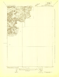 1922 Shasta Valley Sheet No 91922 Print · USGSSiskiyou County irrigation and reclamation efforts come into focus in the early 1920s as engineers surveyed this corner of the valley. Researchers can trace the precise terrain and drainage near Weed and locate the historic Moffit Mill in its original setting.
 - 1922 Map of Shasta Valley Sheet No 8
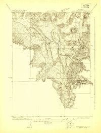 1922 Shasta Valley Sheet No 81922 Print · USGSSiskiyou County's high-valley transport corridor is captured here in the early 1920s as the rail and highway networks expanded. Trace the development of early settlements at Edgewood and Metcalf or locate the historic Parks Creek School.
End of results
Showing maps 1-2 of 2
Top cities near Weed
Frequently asked questions
- What are the different types of historical maps available for Weed?
- What is the oldest map of Weed?
- Where can I purchase historical maps of Weed for my home or office?
- Where can I download high-res historical maps of Weed?
- Are there historical topographic maps available for Weed?
- Is there historical aerial imagery available for Weed?
- Where are historical maps of Weed sourced from?