1900s (20th Century) Maps of Weed, California
Explore 13 historic maps of Weed from the 1900s (20th Century). These maps offer a rare glimpse into what life looked like during the 1900s — showing old roads, neighborhoods, homes, and landmarks that have changed or disappeared over time.
Whether you're researching your family's past, planning a metal detecting trip, or studying how Weed's landscape evolved across the 1900s, these high-resolution maps are a powerful tool for exploring the history of this region.
- Focus on a specific era: All maps on this page are from the 1900s, giving you a focused view of this time period.
- See what’s changed: Compare century-old streets, trails, and buildings to today's modern landscape using overlays and satellite layers.
- Research with precision: Use these maps for genealogy, historical research, land use analysis, or educational projects.
- View, download, or print: Maps are fully viewable online in high resolution, and can be downloaded or printed for your own records.
Start exploring Weed's history through authentic maps from the 1900s. This is your window into the past.
Weed, CA maps
(13)- 1922 Map of Shasta Valley Sheet No 9
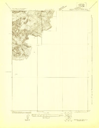 1922 Shasta Valley Sheet No 91922 Print · USGSSiskiyou County irrigation and reclamation efforts come into focus in the early 1920s as engineers surveyed this corner of the valley. Researchers can trace the precise terrain and drainage near Weed and locate the historic Moffit Mill in its original setting.
 - 1922 Map of Shasta Valley Sheet No 8
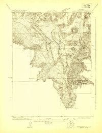 1922 Shasta Valley Sheet No 81922 Print · USGSSiskiyou County's high-valley transport corridor is captured here in the early 1920s as the rail and highway networks expanded. Trace the development of early settlements at Edgewood and Metcalf or locate the historic Parks Creek School.
 - 1935 Map of Dunsmuir
 1935 Dunsmuir1935 Print · USGSUpper Siskiyou and Shasta counties are shown here in the mid-1930s as the rail and timber industries shaped the mountain landscape. Genealogists and historians can trace the Southern Pacific line through Dunsmuir, locate the Cedar Park Sch, or find vanished stops like Sims Sta.4 unique versions available
 - 1948 Map of Weed, 1950 Print
 1948 Weed1950 Print · USGSNorthern California and Southern Oregon are captured here during the post-war era, documenting the mountain-and-valley economies of the Klamath and Cascade ranges. Trace the legacy of local mining and timber at the King Solomon Mine, find old schools like Siskiyou County School, and follow the historic Southern Pacific RR route.2 unique versions available
 - 1950 Map of Weed
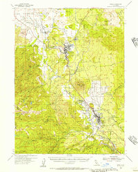
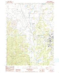
 1950 Weed1950 Print · USGSSiskiyou County and the surrounding Klamath mountains appear in the mid-century before extensive modern development. Genealogists and local historians can locate remote outposts like the Lee Brown Ranch and the specialized settlement of Darlingtonia.
 - 1954 Map of Weed, 1956 Print
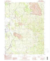
 1954 Weed1956 Print · USGSMount Shasta and its surrounding timber towns come alive in this mid-century survey of Siskiyou County. Researchers can trace the path of the Southern Pacific through Weed and Edgewood, or locate specific landmarks like the Fish Hatchery and Mott.3 unique versions available
 - 1958 Map of Weed, 1963 Print
 1958 Weed1963 Print · USGSThe Northern California high country of the late fifties is defined by the towering presence of Mt Shasta and the logging railroads of the Siskiyou range. Genealogists and researchers can trace remote mining sites like the China Mine and mountain settlements such as Sawyers Bar and Seiad Valley.3 unique versions available
 - 1963 Map of Weed
 1963 Weed1963 Print · USGSNorthern California during the early 1960s shows a landscape of steep mountain ranges and river-fed valleys at the height of the timber era. Researchers can trace the routes of the McCloud River RR, locate remote sites like the Holiday Mine, or find ancestral markers at the Scott Valley Cem.
 - 1979 Map of Mount Shasta
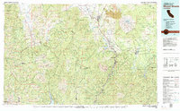 1979 Mount Shasta1979 Print · USGSUpper California's mountainous landscape appears in the late seventies as a busy network of timber towns, railroads, and high-altitude mining claims. Trace the legacy of extraction and industry through the Southern Pacific rail line and sites like McCloud and the Bonanza King Mine.3 unique versions available
 - 1986 Map of Weed
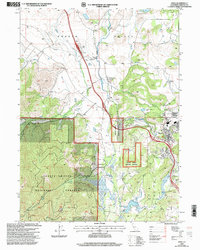
 1986 Weed1986 Print · USGSSiskiyou County in the mid-eighties shows a landscape of mountain timber and valley industry centered on the town of Weed. Researchers can trace the legacy of the Southern Pacific railroad and find localized landmarks like Edgewood, the Dwight Hammond Reservoir, and an Observatory.
 - 1986 Map of Hotlum
 1986 Hotlum1986 Print · USGSThe northern foothills of Mount Shasta come into focus in the mid-1980s, documenting a landscape shaped by volcanic activity and the timber industry. Researchers can trace the layout of Hotlum and the eastern outskirts of Weed near the vast Shasta National Forest.2 unique versions available
 - 1998 Map of Weed, 2003 Print
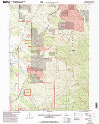
 1998 Weed2003 Print · USGSThe northern reaches of the Shasta Valley come into focus in the late nineties, centered on the community of Weed. Researchers can trace the legacy of the region through the Winema Cem, the Butteville Union School in Edgewood, and the College of the Siskiyous.
 - 1998 Map of Hotlum, 2003 Print
 1998 Hotlum2003 Print · USGSThe volcanic foothills of Siskiyou County are captured here in the late 1990s as industry and wilderness meet. Researchers can trace the layout of Weed and Hotlum, or locate specific landmarks like the Log Pond, Cinder Pits, and Black Butte Spring.
End of results
Showing maps 1-13 of 13
Top cities near Weed
Frequently asked questions
- What are the different types of historical maps available for Weed?
- What is the oldest map of Weed?
- Where can I purchase historical maps of Weed for my home or office?
- Where can I download high-res historical maps of Weed?
- Are there historical topographic maps available for Weed?
- Is there historical aerial imagery available for Weed?
- Where are historical maps of Weed sourced from?