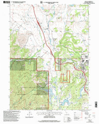
1998 Map of Weed
USGS Topo · Published 2003About this map
Shasta Valley dominates the northern landscape of this 1990s survey, where the Shasta River and its tributaries like Carrick Creek and Parks Creek provide the lifeblood for local industry and settlement. The city of Weed is the primary hub, showing the layout of the College of the Siskiyous and Lincoln Park alongside the industrial infrastructure of Sewage Disposal Ponds and the Weed Airport. To the north, the small community of Edgewood is centered near the Butteville Union School and an old Cem site.
Find a feature on this map
33 named features on this map. Tap any name to fly to it.
Don’t see what you’re looking for? This feature index may not catch every label — zoom into the map to look around manually.
Map Details
Editions of this 1998 Weed Map
This is the sole edition of this map. No revisions or reprints were ever made.
Other maps of this area

1886 · Shasta
USGS Topo · 1:250,000

1894 · Shasta
USGS Topo · 1:250,000

1921 · Shasta Valley Sheet No 7
USGS Topo · 1:24,000

1921 · Shasta Valley Sheet No 1
USGS Topo · 1:24,000

1922 · Shasta Valley Sheet No 10
USGS Topo · 1:24,000

1922 · Shasta Valley Sheet No 1 S
USGS Topo · 1:24,000

1922 · Shasta Valley Sheet No 9
USGS Topo · 1:24,000
1922 · Shasta Valley Sheet No 8
USGS Topo · 1:24,000

1923 · Sawyers Bar
USGS Topo · 1:125,000

1931 · Etna
USGS Topo · 1:96,000