1920s Maps of Stanislaus County, California
Explore 4 historic maps of Stanislaus County from the 1920s. These maps offer a rare glimpse into what life looked like during the 1920s — showing old roads, neighborhoods, homes, and landmarks that have changed or disappeared over time.
Whether you're researching your family's past, planning a metal detecting trip, or studying how Stanislaus County's landscape evolved across the 1920s, these high-resolution maps are a powerful tool for exploring the history of this region.
- Focus on a specific era: All maps on this page are from the 1920s, giving you a focused view of this time period.
- See what’s changed: Compare century-old streets, trails, and buildings to today's modern landscape using overlays and satellite layers.
- Research with precision: Use these maps for genealogy, historical research, land use analysis, or educational projects.
- View, download, or print: Maps are fully viewable online in high resolution, and can be downloaded or printed for your own records.
Start exploring Stanislaus County's history through authentic maps from the 1920s. This is your window into the past.
Stanislaus County, CA maps
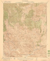
(4)- 1920 Map of Pacheco Pass
 1920 Pacheco Pass1920 Print · USGSThe Pacheco Pass gateway and the eastern Diablo Range are captured here during the early twentieth century. Researchers can trace historic local life through sites like the Bald Eagle Mine, San Luis Ranch, and Cottonwood School.4 unique versions available
 - 1921 Map of Gilroy Hot Springs
 1921 Gilroy Hot Springs1921 Print · USGSThe Diablo Range east of Gilroy reveals a landscape of massive land grants and remote ranching outposts in the early twentieth century. Genealogists and historians can trace family holdings like the Robeson Ranch or locate the historic Bells Station near Pacheco Pass.4 unique versions available
 - 1922 Map of Carbona
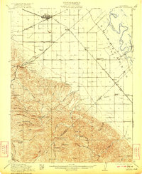 1922 Carbona1922 Print · USGSSan Joaquin County at the dawn of the roaring twenties reveals a bustling rail landscape where the Southern Pacific meets the Western Pacific. Genealogists and historians can trace early school districts like New Jerusalem School and find industrial roots at the Buckeye Mines.3 unique versions available
 - 1922 Map of Howard Ranch
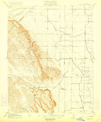 1922 Howard Ranch1922 Print · USGSThe foothills of the Diablo Range meet the San Joaquin Valley in this early twentieth-century survey. Genealogists and historians can trace rural family life through the locations of the Occidental School, Cottonwood Church, and the historic Howard Ranch.2 unique versions available
End of results
Showing maps 1-4 of 4
Top cities of Stanislaus County
- Modesto historical maps
- Turlock historical maps
- Ceres historical maps
- Riverbank historical maps
- Patterson historical maps
- Oakdale historical maps
See more
Frequently asked questions
- What are the different types of historical maps available for Stanislaus County?
- What is the oldest map of Stanislaus County?
- Where can I purchase historical maps of Stanislaus County for my home or office?
- Where can I download high-res historical maps of Stanislaus County?
- Are there historical topographic maps available for Stanislaus County?
- Is there historical aerial imagery available for Stanislaus County?
- Where are historical maps of Stanislaus County sourced from?