1930s Maps of Stanislaus County, California
Explore 3 historic maps of Stanislaus County from the 1930s. These maps offer a rare glimpse into what life looked like during the 1930s — showing old roads, neighborhoods, homes, and landmarks that have changed or disappeared over time.
Whether you're researching your family's past, planning a metal detecting trip, or studying how Stanislaus County's landscape evolved across the 1930s, these high-resolution maps are a powerful tool for exploring the history of this region.
- Focus on a specific era: All maps on this page are from the 1930s, giving you a focused view of this time period.
- See what’s changed: Compare century-old streets, trails, and buildings to today's modern landscape using overlays and satellite layers.
- Research with precision: Use these maps for genealogy, historical research, land use analysis, or educational projects.
- View, download, or print: Maps are fully viewable online in high resolution, and can be downloaded or printed for your own records.
Start exploring Stanislaus County's history through authentic maps from the 1930s. This is your window into the past.
Stanislaus County, CA maps
(3)- 1938 Map of Mt. Boardman, 1957 Print
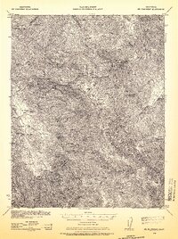 1938 Mt. Boardman1957 Print · USGSThe Diablo Range backcountry in the late 1930s is revealed here as a landscape of isolated ranching and mining. Researchers can locate family landmarks like Gerber Ranch or trace the early development of the Western Mine and Shanti Ashrama.3 unique versions available
 - 1939 Map of Gilroy Hot Springs, 1958 Print
 1939 Gilroy Hot Springs1958 Print · USGSThe Diablo Range in the late thirties was a rugged landscape of high peaks and isolated ranching outposts. Local historians can trace early thoroughfares like Pacheco Pass Road and find family-named landmarks including Robeson Ranch and Gilroy Hot Springs.
 - 1939 Map of Modesto East, 1965 Print
 1939 Modesto East1965 Print · USGSStanislaus County thrived as a rail and irrigation hub just before the Second World War. Genealogists can locate family-named landmarks like Thompson Rancho, rural schoolhouses such as Bellpassi School, and the Stanislaus Cem burial grounds.
End of results
Showing maps 1-3 of 3
Top cities of Stanislaus County
- Modesto historical maps
- Turlock historical maps
- Ceres historical maps
- Riverbank historical maps
- Patterson historical maps
- Oakdale historical maps
See more
Frequently asked questions
- What are the different types of historical maps available for Stanislaus County?
- What is the oldest map of Stanislaus County?
- Where can I purchase historical maps of Stanislaus County for my home or office?
- Where can I download high-res historical maps of Stanislaus County?
- Are there historical topographic maps available for Stanislaus County?
- Is there historical aerial imagery available for Stanislaus County?
- Where are historical maps of Stanislaus County sourced from?