1950s Maps of Oakdale, California
Explore 5 historic maps of Oakdale from the 1950s. These maps offer a rare glimpse into what life looked like during the 1950s — showing old roads, neighborhoods, homes, and landmarks that have changed or disappeared over time.
Whether you're researching your family's past, planning a metal detecting trip, or studying how Oakdale's landscape evolved across the 1950s, these high-resolution maps are a powerful tool for exploring the history of this region.
- Focus on a specific era: All maps on this page are from the 1950s, giving you a focused view of this time period.
- See what’s changed: Compare century-old streets, trails, and buildings to today's modern landscape using overlays and satellite layers.
- Research with precision: Use these maps for genealogy, historical research, land use analysis, or educational projects.
- View, download, or print: Maps are fully viewable online in high resolution, and can be downloaded or printed for your own records.
Start exploring Oakdale's history through authentic maps from the 1950s. This is your window into the past.
Oakdale, CA maps
(5)- 1953 Map of Escalon, 1954 Print
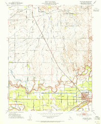
 1953 Escalon1954 Print · USGSSan Joaquin County agriculture and rail industry thrived mid-century as these two major railroads converged. Researchers can trace the layout of early schools like Union High Sch and Burwood Sch or locate family plots at Burwood Cem.
 - 1953 Map of Riverbank, 1954 Print
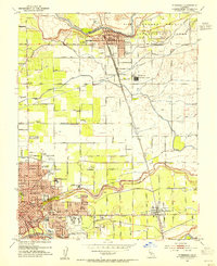 1953 Riverbank1954 Print · USGSMid-century Modesto and Riverbank are shown here as the postwar agricultural economy is being joined by major industrial and aviation expansion. Researchers can find many family landmarks, including Belpassi School, the Riverbank Ordnance Plant, and the small settlement of D'Accardo.
 - 1953 Map of Oakdale, 1955 Print
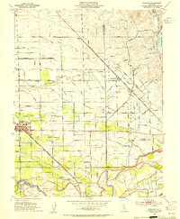
 1953 Oakdale1955 Print · USGSOakdale and the surrounding Stanislaus County plains were defined by a robust rail-and-canal economy in the early fifties. Researchers can trace the dual tracks of the Southern Pacific and Atchison Topeka and Santa Fe Railroad near the Orange Blossom Bridge.
 - 1953 Map of Waterford, 1955 Print
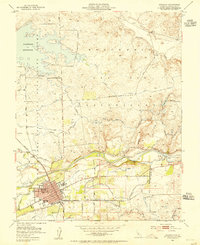
 1953 Waterford1955 Print · USGSWaterford and the surrounding agricultural lands are captured here in the mid-1950s as irrigation systems reshaped the landscape. Researchers can trace the Southern Pacific rail line through Claribel and locate regional landmarks like the local Winery and Gravel Pits.
 - 1956 Map of San Jose
 1956 San Jose1956 Print · USGSCentral California in the mid-fifties reveals the transition from sprawling orchards to growing urban hubs like San Jose and Stockton. Genealogists and historians can trace the rail-era landscape of the Mother Lode through Chinese Camp and Tuttletown, or follow the water through the Joaquin River and Calaveras Reservoir.
End of results
Showing maps 1-5 of 5
Top cities near Oakdale
- Modesto historical maps
- Ceres historical maps
- Riverbank historical maps
- Waterford historical maps
- Escalon historical maps
- Hughson historical maps
See more
Frequently asked questions
- What are the different types of historical maps available for Oakdale?
- What is the oldest map of Oakdale?
- Where can I purchase historical maps of Oakdale for my home or office?
- Where can I download high-res historical maps of Oakdale?
- Are there historical topographic maps available for Oakdale?
- Is there historical aerial imagery available for Oakdale?
- Where are historical maps of Oakdale sourced from?