Old Maps of Henleyville, California for Academic Research
Study the evolution of Henleyville with 11 high-resolution historic maps. Whether you're teaching, researching, or modeling changes in land use, these maps provide essential visual documentation of urban, environmental, and geographic change.
- Analyze long-term change: Track patterns in development, transportation, and natural features.
- Ideal for environmental or urban studies: Support academic projects with primary historical map data.
- Use in the classroom or lab: Educators and researchers rely on these maps to bring historical context to life.
These maps are a powerful tool for teaching, research, and visualizing how Henleyville has changed over the decades.
Henleyville, CA maps
(11)- 1944 Map of Flournoy
 1944 Flournoy1944 Print · USGSThe foothills of Tehama and Glenn Counties during the early 1940s reveal a landscape shaped by seasonal creeks and early irrigation. Researchers can trace the rural communities of Flournoy and Henleyville alongside historical markers like the Nome Lacke Monument.2 unique versions available
 - 1957 Map of Ukiah, 1966 Print
 1957 Ukiah1966 Print · USGSNorthern California's diverse terrain comes into focus in the mid-1950s, from the rugged timberlands of the Jackson State Forest to the productive Sacramento Valley. Genealogists and historians can trace the rail lines of the Northwestern Pacific or locate early valley settlements like Arbuckle and Paskenta.3 unique versions available
 - 1958 Map of Flournoy, 1959 Print
 1958 Flournoy1959 Print · USGSThe foothills of Tehama and Glenn counties are captured here in the late fifties, showcasing a rural landscape of ranching and early irrigation. Researchers can locate the Flournoy settlement, the local cemetery, and old thoroughfares like School House Road.
 - 1960 Map of Ukiah
 1960 Ukiah1960 Print · USGSNorthern California during the late fifties reveals a landscape of deep timber forests and valley agriculture before modern expansion. Trace the historic rail lines of the California Western RR and the Northwestern Pacific RR through settlements like Fort Bragg and Ukiah.2 unique versions available
 - 1967 Map of Henleyville, 1968 Print
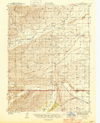
 1967 Henleyville1968 Print · USGSThe ranching country of western Tehama County comes into focus in the 1960s, centered on the small settlement of Henleyville. Genealogists and local historians can trace family-named routes such as Chittenden Road and landmarks like Butte Mtn.
 - 1987 Map of Willows, 1988 Print
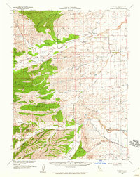
 1987 Willows1988 Print · USGSThe northern Sacramento Valley meets the Coast Range in the late eighties, showing a landscape defined by water and transit. Researchers can trace the Southern Pacific railroad past Artois and Corning, or locate family-named landmarks like Larkins Childrens Rancho and Snaden Island.2 unique versions available
 - 2012 Map of Henleyville, 2012 Print
 2012 Henleyville2012 Print · USGSCovers Henleyville, including Tehama County, United States, and other nearby areas
 - 2015 Map of Henleyville, 2015 Print
 2015 Henleyville2015 Print · USGSCovers Henleyville, including Tehama County, United States, and other nearby areas
 - 2018 Map of Henleyville, 2018 Print
 2018 Henleyville2018 Print · USGSCovers Henleyville, including Tehama County, United States, and other nearby areas
 - 2021 Map of Henleyville, 2021 Print
 2021 Henleyville2021 Print · USGSCovers Henleyville, including Tehama County, United States, and other nearby areas
 - 2023 Map of Henleyville, 2023 Print
 2023 Henleyville2023 Print · USGSThe Sacramento Valley meets the western foothills in the early 2020s, showing a landscape defined by seasonal creeks and orchard lands. Trace the rural layout of Henleyville and local landmarks like Freeman Schoolhouse Rd and Laybas Hollow.
End of results
Showing maps 1-11 of 11
Top cities near Henleyville
- Red Bluff historical maps
- Corning historical maps
- Los Molinos historical maps
- Rancho Tehama Reserve historical maps
- Tehama historical maps
- Flournoy historical maps
Frequently asked questions
- What are the different types of historical maps available for Henleyville?
- What is the oldest map of Henleyville?
- Where can I purchase historical maps of Henleyville for my home or office?
- Where can I download high-res historical maps of Henleyville?
- Are there historical topographic maps available for Henleyville?
- Is there historical aerial imagery available for Henleyville?
- Where are historical maps of Henleyville sourced from?