1960s Maps of Rancho Tehama Reserve, California
Explore 4 historic maps of Rancho Tehama Reserve from the 1960s. These maps offer a rare glimpse into what life looked like during the 1960s — showing old roads, neighborhoods, homes, and landmarks that have changed or disappeared over time.
Whether you're researching your family's past, planning a metal detecting trip, or studying how Rancho Tehama Reserve's landscape evolved across the 1960s, these high-resolution maps are a powerful tool for exploring the history of this region.
- Focus on a specific era: All maps on this page are from the 1960s, giving you a focused view of this time period.
- See what’s changed: Compare century-old streets, trails, and buildings to today's modern landscape using overlays and satellite layers.
- Research with precision: Use these maps for genealogy, historical research, land use analysis, or educational projects.
- View, download, or print: Maps are fully viewable online in high resolution, and can be downloaded or printed for your own records.
Start exploring Rancho Tehama Reserve's history through authentic maps from the 1960s. This is your window into the past.
Rancho Tehama Reserve, CA maps
(4)- 1960 Map of Ukiah
 1960 Ukiah1960 Print · USGSNorthern California during the late fifties reveals a landscape of deep timber forests and valley agriculture before modern expansion. Trace the historic rail lines of the California Western RR and the Northwestern Pacific RR through settlements like Fort Bragg and Ukiah.2 unique versions available
 - 1967 Map of Flournoy, 1968 Print
 1967 Flournoy1968 Print · USGSThe community of Flournoy and the surrounding ranch lands are captured here during the late 1960s, framed by the Thomes Creek watershed. Genealogists and historians can trace the Indian Treaty Boundary and find the site of the Flournoy Sch and the Name Lackee Indian Reservation Monument.2 unique versions available
 - 1967 Map of Lowrey, 1969 Print
 1967 Lowrey1969 Print · USGSThe foothills of Tehama County are captured here in the late sixties, centered on the settlement of Lowrey. Researchers can trace old property lines along the Indian Treaty Boundary or locate family sites at Rouse Gardens and the Lowrey Cem.
 - 1967 Map of Paskenta, 1969 Print
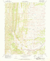 1967 Paskenta1969 Print · USGSTehama County's rugged eastern foothills are captured here in the late sixties, centered on the settlement of Paskenta and its surrounding ranch lands. Researchers can trace the path of the Old Indian Treaty Boundary or locate family sites like Rouse Gardens and Paskenta Cemetery.2 unique versions available
End of results
Showing maps 1-4 of 4
Top cities near Rancho Tehama Reserve
Frequently asked questions
- What are the different types of historical maps available for Rancho Tehama Reserve?
- What is the oldest map of Rancho Tehama Reserve?
- Where can I purchase historical maps of Rancho Tehama Reserve for my home or office?
- Where can I download high-res historical maps of Rancho Tehama Reserve?
- Are there historical topographic maps available for Rancho Tehama Reserve?
- Is there historical aerial imagery available for Rancho Tehama Reserve?
- Where are historical maps of Rancho Tehama Reserve sourced from?