1950s Maps of Rancho Tehama Reserve, California
Explore 7 historic maps of Rancho Tehama Reserve from the 1950s. These maps offer a rare glimpse into what life looked like during the 1950s — showing old roads, neighborhoods, homes, and landmarks that have changed or disappeared over time.
Whether you're researching your family's past, planning a metal detecting trip, or studying how Rancho Tehama Reserve's landscape evolved across the 1950s, these high-resolution maps are a powerful tool for exploring the history of this region.
- Focus on a specific era: All maps on this page are from the 1950s, giving you a focused view of this time period.
- See what’s changed: Compare century-old streets, trails, and buildings to today's modern landscape using overlays and satellite layers.
- Research with precision: Use these maps for genealogy, historical research, land use analysis, or educational projects.
- View, download, or print: Maps are fully viewable online in high resolution, and can be downloaded or printed for your own records.
Start exploring Rancho Tehama Reserve's history through authentic maps from the 1950s. This is your window into the past.
Rancho Tehama Reserve, CA maps
(7)- 1952 Map of Red Bank, 1953 Print
 1952 Red Bank1953 Print · USGSTehama County's ranching landscape is captured here in the early fifties, showing the rural settlement patterns before modern expansion. Genealogists and historians can trace family-named routes and landmarks like Stampfli Road, Elk Flat, and the Grain Tanks near Red Bank.2 unique versions available
 - 1952 Map of Paskenta, 1953 Print
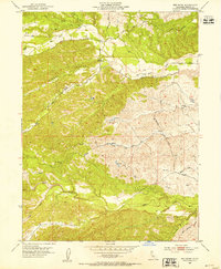
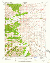
 1952 Paskenta1953 Print · USGSThe foothills of Tehama and Glenn counties come to life in this mid-century survey of the Mendocino National Forest borderlands. Genealogists and local historians can trace family holdings like the Scribner Ranch and Cushman Ranch, or find the old Lowrey Sch.3 unique versions available
 - 1952 Map of Red Bank, 1959 Print
 1952 Red Bank1959 Print · USGSTehama County in the early fifties shows a landscape of cattle ranches and small rural schools west of the Sacramento River. Genealogists and local researchers can trace family lands near St Marys Cem, Red Bank, and the Reeds Creek School.2 unique versions available
 - 1957 Map of Colyear Springs, 1959 Print
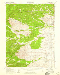
 1957 Colyear Springs1959 Print · USGSTehama County in the late fifties was a landscape of remote family homesteads and national forest tracts. Researchers can trace early land use through named sites like the Burrill Homestead, Schoolhouse Flat, and the Lowrey Cemetery.2 unique versions available
 - 1957 Map of Ukiah, 1966 Print
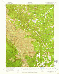
 1957 Ukiah1966 Print · USGSNorthern California's diverse terrain comes into focus in the mid-1950s, from the rugged timberlands of the Jackson State Forest to the productive Sacramento Valley. Genealogists and historians can trace the rail lines of the Northwestern Pacific or locate early valley settlements like Arbuckle and Paskenta.3 unique versions available
 - 1958 Map of Redding
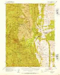
 1958 Redding1958 Print · USGSNorthern California's valley and mountain landscapes are captured in the late fifties, showing the region as new reservoirs reshaped the river systems. Genealogists and historians can trace rail-side towns like Cottonwood, the military presence at Red Bluff Air Force Station, and mountain outposts like Weaverville.5 unique versions available
 - 1958 Map of Flournoy, 1959 Print
 1958 Flournoy1959 Print · USGSThe foothills of Tehama and Glenn counties are captured here in the late fifties, showcasing a rural landscape of ranching and early irrigation. Researchers can locate the Flournoy settlement, the local cemetery, and old thoroughfares like School House Road.
End of results
Showing maps 1-7 of 7
Top cities near Rancho Tehama Reserve
Frequently asked questions
- What are the different types of historical maps available for Rancho Tehama Reserve?
- What is the oldest map of Rancho Tehama Reserve?
- Where can I purchase historical maps of Rancho Tehama Reserve for my home or office?
- Where can I download high-res historical maps of Rancho Tehama Reserve?
- Are there historical topographic maps available for Rancho Tehama Reserve?
- Is there historical aerial imagery available for Rancho Tehama Reserve?
- Where are historical maps of Rancho Tehama Reserve sourced from?