1900s (20th Century) Maps of Coffee Creek, California
Explore 12 historic maps of Coffee Creek from the 1900s (20th Century). These maps offer a rare glimpse into what life looked like during the 1900s — showing old roads, neighborhoods, homes, and landmarks that have changed or disappeared over time.
Whether you're researching your family's past, planning a metal detecting trip, or studying how Coffee Creek's landscape evolved across the 1900s, these high-resolution maps are a powerful tool for exploring the history of this region.
- Focus on a specific era: All maps on this page are from the 1900s, giving you a focused view of this time period.
- See what’s changed: Compare century-old streets, trails, and buildings to today's modern landscape using overlays and satellite layers.
- Research with precision: Use these maps for genealogy, historical research, land use analysis, or educational projects.
- View, download, or print: Maps are fully viewable online in high resolution, and can be downloaded or printed for your own records.
Start exploring Coffee Creek's history through authentic maps from the 1900s. This is your window into the past.
Coffee Creek, CA maps
(12)- 1923 Map of Sawyers Bar
 1923 Sawyers Bar1923 Print · USGSThe Salmon River canyon in the early 1900s reveals a high-country mining landscape during the height of its activity. Genealogists and historians can trace families at Edie Ranch, locate remote classrooms like Russianville School, and find numerous prospects including the Black Bear Mine.4 unique versions available
 - 1931 Map of Etna
 1931 Etna1931 Print · USGSThe mining camps and river valleys of the Siskiyou-Trinity border are caught in detail during the early 1930s. Researchers can trace historic claims and remote family holdings like the Bonanza King Mine, Etna Ranch, and the East Fork District Sch.
 - 1934 Map of Etna
 1934 Etna1934 Print · USGSThe Scott Valley and high California peaks are seen here in the 1930s as centers of mining and remote mountain ranching. Researchers can trace historic family-named locations such as Parker Ranch, Stoddard Cabin, and the Zarina Mine.4 unique versions available
 - 1948 Map of Weed, 1950 Print
 1948 Weed1950 Print · USGSNorthern California and Southern Oregon are captured here during the post-war era, documenting the mountain-and-valley economies of the Klamath and Cascade ranges. Trace the legacy of local mining and timber at the King Solomon Mine, find old schools like Siskiyou County School, and follow the historic Southern Pacific RR route.2 unique versions available
 - 1950 Map of Weed
 1950 Weed1950 Print · USGSSiskiyou County and the surrounding Klamath mountains appear in the mid-century before extensive modern development. Genealogists and local historians can locate remote outposts like the Lee Brown Ranch and the specialized settlement of Darlingtonia.
 - 1955 Map of Bonanza King, 1957 Print
 1955 Bonanza King1957 Print · USGSThe Trinity River valley in the mid-fifties is captured here during a time of active ranching and high-country mining. Genealogists and historians can locate old homesteads like Eagle Creek Ranch and traces of the mining era at Altoona Mine or the Integral Mine.4 unique versions available
 - 1958 Map of Weed, 1963 Print
 1958 Weed1963 Print · USGSThe Northern California high country of the late fifties is defined by the towering presence of Mt Shasta and the logging railroads of the Siskiyou range. Genealogists and researchers can trace remote mining sites like the China Mine and mountain settlements such as Sawyers Bar and Seiad Valley.3 unique versions available
 - 1963 Map of Weed
 1963 Weed1963 Print · USGSNorthern California during the early 1960s shows a landscape of steep mountain ranges and river-fed valleys at the height of the timber era. Researchers can trace the routes of the McCloud River RR, locate remote sites like the Holiday Mine, or find ancestral markers at the Scott Valley Cem.
 - 1969 Map of Bonanza King, 1971 Print
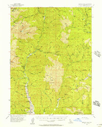
 1969 Bonanza King1971 Print · USGSThe Trinity Alps region at the end of the 1960s shows a landscape of historic mining claims and new recreation areas. Researchers can trace the heritage of the Bonanza King Mine or locate the site of Carrville near the shores of Clair Engle Lake.
 - 1979 Map of Mount Shasta
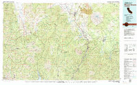 1979 Mount Shasta1979 Print · USGSUpper California's mountainous landscape appears in the late seventies as a busy network of timber towns, railroads, and high-altitude mining claims. Trace the legacy of extraction and industry through the Southern Pacific rail line and sites like McCloud and the Bonanza King Mine.3 unique versions available
 - 1986 Map of Carrville
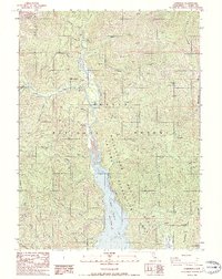 1986 Carrville1986 Print · USGSNorthern Trinity County at the height of the mid-eighties shows a landscape shaped by both recreation and resource extraction. Genealogists and researchers can trace the vicinity of Carrville, locate a riverside Cem, and explore landmarks like One-eyed Flat or the Trinity River.
 - 1998 Map of Carrville, 2003 Print
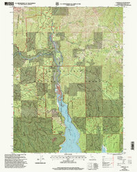 1998 Carrville2003 Print · USGSTrinity County at the edge of the wilderness reveals a landscape defined by mining history and the waters of the Trinity River. Local researchers can trace old family sites and mountain industry at the Bonanza King Mine, Carrville, and One-eyed Flat.
End of results
Showing maps 1-12 of 12
Frequently asked questions
- What are the different types of historical maps available for Coffee Creek?
- What is the oldest map of Coffee Creek?
- Where can I purchase historical maps of Coffee Creek for my home or office?
- Where can I download high-res historical maps of Coffee Creek?
- Are there historical topographic maps available for Coffee Creek?
- Is there historical aerial imagery available for Coffee Creek?
- Where are historical maps of Coffee Creek sourced from?