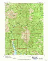
1969 Map of Bonanza King
USGS Topo · Published 1971About this map
Carrville and the surrounding river valleys define this 1969 revision of the Trinity Alps region, where the gold and mercury mining legacy of Northern California is clearly etched. Deep in the Shasta National Forest, the map details a landscape transition where the rising waters of Clair Engle Lake meet the historic drainage of the Trinity River. The survey identifies numerous industrial sites including the Bonanza King Mine and the Altoona Mine, alongside family holdings such as Eagle Creek Ranch and Trumble Ranch. High-altitude basins like Mumbo Basin and Tangle Blue Divide separate the watersheds of Coffee Creek and the North Fork Trinity River. The inclusion of the Whiskeytown-Shasta-Trinity National Recreation Area boundary reflects the shift toward mid-century conservation and recreation in a territory previously dominated by mineral extraction.
Find a feature on this map
75 named features on this map. Tap any name to fly to it.
Don’t see what you’re looking for? This feature index may not catch every label — zoom into the map to look around manually.
Map Details
Editions of this 1969 Bonanza King Map
This is the sole edition of this map. No revisions or reprints were ever made.
Other maps of this area

1886 · Shasta
USGS Topo · 1:250,000

1890 · Red Bluff
USGS Topo · 1:250,000

1894 · Red Bluff
USGS Topo · 1:250,000

1894 · Shasta
USGS Topo · 1:250,000

1901 · Redding
USGS Topo · 1:125,000

1913 · Weaverville
USGS Topo · 1:125,000

1923 · Sawyers Bar
USGS Topo · 1:125,000

1931 · Etna
USGS Topo · 1:96,000

1934 · Etna
USGS Topo · 1:125,000

1935 · Dunsmuir
USGS Topo · 1:125,000