Old Maps of Kekawaka, California for Academic Research
Study the evolution of Kekawaka with 10 high-resolution historic maps. Whether you're teaching, researching, or modeling changes in land use, these maps provide essential visual documentation of urban, environmental, and geographic change.
- Analyze long-term change: Track patterns in development, transportation, and natural features.
- Ideal for environmental or urban studies: Support academic projects with primary historical map data.
- Use in the classroom or lab: Educators and researchers rely on these maps to bring historical context to life.
These maps are a powerful tool for teaching, research, and visualizing how Kekawaka has changed over the decades.
Kekawaka, CA maps
(10)- 1920 Map of Harris
 1920 Harris1920 Print · USGSHumboldt County ranching and rail life are recorded here during the early twentieth century as the railroad carved its path through the Eel River canyon. Researchers can trace historic family holdings like Carey Ranch or locate early industrial sites such as the Steelhead US Fish Hatchery and Fort Seward.
 - 1949 Map of Alderpoint, 1955 Print
 1949 Alderpoint1955 Print · USGSHumboldt County ranching and timber life are captured here in the late 1940s as the railroad follows the winding Eel River. Researchers can trace old family holdings like Ware Ranch and Marr Ranch or locate the site of the Harris PO and Fort Seward.3 unique versions available
 - 1951 Map of Alderpoint
 1951 Alderpoint1951 Print · USGSSouthern Humboldt County is captured here at a time when the river-and-rail economy still shaped life along the Eel River. Researchers can trace old family holdings like Ware Ranch and Marr Ranch or locate the Harris PO and the Lumber Mill at Alderpoint.2 unique versions available
 - 1958 Map of Redding
 1958 Redding1958 Print · USGSNorthern California's valley and mountain landscapes are captured in the late fifties, showing the region as new reservoirs reshaped the river systems. Genealogists and historians can trace rail-side towns like Cottonwood, the military presence at Red Bluff Air Force Station, and mountain outposts like Weaverville.5 unique versions available
 - 1969 Map of Jewett Rock, 1974 Print
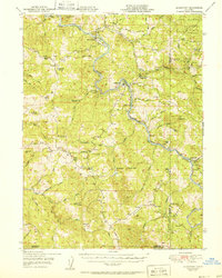
 1969 Jewett Rock1974 Print · USGSThe Eel River canyon and surrounding ridgelines of Humboldt County are captured here just before the 1970s. Trace the remote rail operations of the Northwestern Pacific and find family landmarks like White Ranch, Schroeder Rock, and the Kekawaka Sta.2 unique versions available
 - 1979 Map of Garberville, 1996 Print
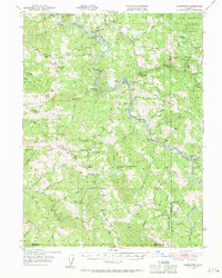
 1979 Garberville1996 Print · USGSThe redwood forests and river canyons of Humboldt and Trinity counties are shown here in the late seventies. Genealogists and historians can trace rail-side life along the Northwestern Pacific RR or locate small settlements like Fort Seward, Alderpoint, and Zenia.
 - 2012 Map of Jewett Rock, 2012 Print
 2012 Jewett Rock2012 Print · USGSCovers Kekawaka, including Humboldt County, Mendocino County, and other nearby areas
 - 2015 Map of Jewett Rock, 2015 Print
 2015 Jewett Rock2015 Print · USGSCovers Kekawaka, including Humboldt County, Mendocino County, and other nearby areas
 - 2018 Map of Jewett Rock, 2018 Print
 2018 Jewett Rock2018 Print · USGSCovers Kekawaka, including Humboldt County, Mendocino County, and other nearby areas
 - 2021 Map of Jewett Rock, 2021 Print
 2021 Jewett Rock2021 Print · USGSThe Eel River canyon and the rugged interior of the Coast Ranges are captured here in the early twenty-first century. Researchers can trace the path of Island Mountain Rd across Walker Ridge to landmarks like Jewett Rock and the settlement of Kekawaka.
End of results
Showing maps 1-10 of 10
Top cities near Kekawaka
Frequently asked questions
- What are the different types of historical maps available for Kekawaka?
- What is the oldest map of Kekawaka?
- Where can I purchase historical maps of Kekawaka for my home or office?
- Where can I download high-res historical maps of Kekawaka?
- Are there historical topographic maps available for Kekawaka?
- Is there historical aerial imagery available for Kekawaka?
- Where are historical maps of Kekawaka sourced from?