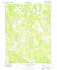
1969 Map of Jewett Rock
USGS Topo · Published 1974About this map
Northwestern Pacific tracks dominate the riverine corridor of this late 1960s survey, following the winding course of the Eel River through the heart of the Emerald Triangle. This rugged region, where Humboldt, Trinity, and Mendocino counties meet, reveals a landscape of isolated homesteads and high ridgelines. Local genealogy and land-use history are anchored by names like White Ranch, Wood Ranch, and Lauffer Ranch, while a small Cem and a lone Grave near Jewett Creek mark the early settlement footprint in Jewett Valley. The map records a transition in transport and utility, showing a Landing Strip on Chamise Ridge and the Kekawaka Sta along the rail line, alongside natural landmarks like the prominent Jewett Rock and Walker Island Mountain.
Find a feature on this map
39 named features on this map. Tap any name to fly to it.
Don’t see what you’re looking for? This feature index may not catch every label — zoom into the map to look around manually.
Map Details
Editions of this 1969 Jewett Rock Map
2 editions found
Other maps of this area

1920 · Cummings
USGS Topo · 1:62,500

1920 · Covelo
USGS Topo · 1:62,500

1920 · Harris
USGS Topo · 1:62,500

1921 · Hoaglin
USGS Topo · 1:62,500

1922 · Island Mountain
USGS Topo · 1:62,500

1931 · Hoaglin
USGS Topo · 1:96,000

1935 · Hoaglin
USGS Topo · 1:125,000

1949 · Alderpoint
USGS Topo · 1:62,500

1951 · Alderpoint
USGS Topo · 1:62,500

1952 · Spyrock
USGS Topo · 1:62,500