Old Maps of Yuba County, California for Metal Detecting
Plan your next treasure hunt with 187 historic maps of Yuba County. Find old homesites, ghost towns, trails, and gathering spots that may be lost to time — perfect for identifying promising metal detecting locations.
- Locate forgotten sites: Uncover places like long-lost settlements, abandoned rail lines, or gathering spots.
- Plan better hunts: Use map overlays combined with LiDAR or satellite views to narrow in on historically rich areas.
- Made for detectorists: Thousands of hobbyists use these maps to discover relics, coins, and hidden history.
Use these historic maps to boost your research and find new opportunities beneath the surface of Yuba County.
Yuba County, CA maps
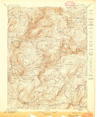
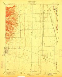
(187)- 1888 Map of Marysville
 1888 Marysville1888 Print · USGSThe Sacramento Valley in the late nineteenth century was a landscape of fertile river bottoms and emerging rail towns. Researchers can trace the river economy through Moons Ferry and Eddys Ferry or locate early family holdings like Hock Farm and Butte House.
 - 1888 Map of Smartsville
 1888 Smartsville1888 Print · USGSGold Country was in its industrial prime during the late eighteen-hundreds, with deep-shaft mines and hydraulic camps dotting the Sierra foothills. Researchers can trace early family holdings and mining claims through landmarks like French Corral, the North Star Mine, and the historic settlement of Timbuctoo.
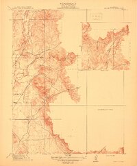
 - 1888 Map of Bidwell Bar, 1956 Print
 1888 Bidwell Bar1956 Print · USGSThe northern Sierra foothills and Feather River canyons come alive in the late nineteenth century before modern reservoirs altered the landscape. Genealogists and researchers can trace family-named sites like Fields Ranch, Spanish Ranch, and Snows Mine.
 - 1891 Map of Bidwell Bar
 1891 Bidwell Bar1891 Print · USGSThe gold-country ridges and deep river canyons of the northern Sierras are shown in the late nineteenth century as mining and timber production shaped the land. Researchers can trace early family-named waystations and industrial sites like American House, Bidwell Bar, and Clipper Mill.
 - 1891 Map of Sacramento
 1891 Sacramento1891 Print · USGSNorthern California foothills and the valley plains emerge in the late nineteenth century as the rail-and-road network expands. Trace early family landmarks and river crossings like Mormon Island, Whitney Ranch, and the historic Rattlesnake Bridge.
 - 1891 Map of Marysville
 1891 Marysville1891 Print · USGSThe Sacramento Valley in the late nineteenth century centers on the volcanic peaks of the Marysville Buttes. Genealogists and historians can trace pioneer landings and river crossings such as Hock Farm, Princeton Ferry, and the early street grids of Sutter City.
 - 1891 Map of Smartsville
 1891 Smartsville1891 Print · USGSGold Country in the late nineteenth century was a landscape of deep mines and timber rails. This survey allows researchers to trace the industrial footprint of the Idaho and North Star Mine alongside vanished camps like Condemned Bar and French Corral.
 - 1892 Map of Sacramento
 1892 Sacramento1892 Print · USGSThe rail-and-river economy of Northern California is on full display in the 1890s as the Central Pacific Railroad links the valley to the foothills. Genealogists and historians can trace early settlements like Mormon Island, Salmon Falls, and the Whitney's Ranch before modern development changed the landscape.5 unique versions available
 - 1892 Map of Smartsville
 1892 Smartsville1892 Print · USGSThe gold-bearing ridges of the Sierra foothills are captured here in the late nineteenth century, showing the height of the hard-rock mining boom. Researchers can trace the narrow-gauge rail lines and locate famous claims including the Empire Mine, Idaho Mine, and the Sulphuret Works.
 - 1893 Map of Bidwell Bar
 1893 Bidwell Bar1893 Print · USGSThe Plumas mountains during the late nineteenth century show a landscape defined by gold-era mining and remote stage stops. Genealogists and historians can locate early homesteads and industrial sites like Snows Mine, American House, and Bidwell Bar.
 - 1893 Map of Sacramento, 1900 Print
 1893 Sacramento1900 Print · USGSThe Sacramento Valley and Sierra foothills come alive in this late nineteenth-century survey during the height of the railroad era. Researchers can trace the early layout of Roseville, locate family landmarks like Whitney's Ranch, or follow the Placerville Road through the gold country.
 - 1894 Map of Smartsville
 1894 Smartsville1894 Print · USGSIn the mid-1880s, the Sierra foothills around Nevada City and Grass Valley were a hive of mining and ranching activity. Genealogists and historians can trace old homesteads like Lanes Ranch, follow the Nevada Co Narrow Gauge RR, and locate forgotten camps like Rough & Ready.
 - 1894 Map of Marysville
 1894 Marysville1894 Print · USGSThe Sacramento Valley in the 1890s is captured here as a landscape of river ferries and expanding rail lines. Genealogists can trace family footprints in Sutter City, identify old river crossings like Moons Ferry, or locate the historic Hock Farm.
 - 1895 Map of Marysville
 1895 Marysville1895 Print · USGSThe Sacramento Valley in the 1890s centered on the dramatic profile of the Marysville Buttes and a bustling river-and-rail economy. Researchers can trace early river crossings like Moons Ferry, the historic Hock Farm, and the early footprints of Marysville and Yuba City.6 unique versions available
 - 1895 Map of Bidwell Bar
 1895 Bidwell Bar1895 Print · USGSThe Sierra foothills and high ridges of Northern California are captured here in the late nineteenth century. Genealogists and historians can trace isolated waystations and timber camps like American House, Spanish Ranch, and the Old Defiance Mill.
 - 1895 Map of Smartsville
 1895 Smartsville1895 Print · USGSThe Northern Mother Lode thrives during the peak of industrial quartz mining in the late nineteenth century. Researchers can trace the complex rail and mine networks of Nevada City and Grass Valley, alongside historic outposts like Smartsville and Rough & Ready.6 unique versions available
 - 1897 Map of Bidwell Bar
 1897 Bidwell Bar1897 Print · USGSThe Sierra Nevada foothills and river canyons come alive in the 1890s as a landscape of remote mines and mountain ranching. Genealogists can trace early homesteads and social hubs like Spanish Ranch, Forbestown, and Old Defiance Mill.7 unique versions available
 - 1910 Map of Sheridan
 1910 Sheridan1910 Print · USGSNear the Placer and Sutter county line in the early 1900s, this area was a landscape of historic land grants and vital rail links. Genealogists and historians can trace the tracks of the S. P. R. R. (Marysville Line) past Sheridan and locate the rural Fairview School.2 unique versions available
 - 1910 Map of Wheatland
 1910 Wheatland1910 Print · USGSThe Wheatland area at the dawn of the twentieth century was a landscape of expansive ranching lands and developing rail corridors. Researchers can trace the massive Johnson Rancho boundary, locate the Eagle School, and find the early settlement of Horstville.2 unique versions available
 - 1910 Map of Nicolaus
 1910 Nicolaus1910 Print · USGSSutter County thrives at the junction of the Feather and Bear rivers during the early 1900s rail expansion. Genealogy and local history researchers can trace old rail stops at Nicolaus Sta and Rio Oso or locate landmarks like the Illinois School.2 unique versions available
 - 1911 Map of Sutter
 1911 Sutter1911 Print · USGSAgricultural life in the Sacramento Valley thrived during the early 1900s, anchored by the iconic Marysville Buttes. Genealogists and historians can trace the local school districts of Liveoak School and Washington School or locate rail stops at Nuestro and Encinal.
 - 1911 Map of Browns Valley
 1911 Browns Valley1911 Print · USGSThe gold country of Yuba County is captured here in the early twentieth century. Family historians and researchers can trace old road networks like the Wheatland Road and locate early rural sites such as Hammonton and Brophy School.
 - 1911 Map of Yuba City
 1911 Yuba City1911 Print · USGSThe confluence of the Feather and Yuba Rivers comes to life in the early twentieth century, showing a region deeply tied to its rail and water networks. Genealogists and historians can trace the exact 1909 footprints of Marysville, Woodruff School, and the Southern Pacific RR.2 unique versions available
 - 1911 Map of Ostrom
 1911 Ostrom1911 Print · USGSThe Yuba County lowlands were a hub of competing rail lines and river transport in the years before the Great War. Genealogists can trace family footprints near Ella School, the stop at Alicia, or the historic wetlands of Plumas Lake.
 - 1912 Map of Prairie Creek
 1912 Prairie Creek1912 Print · USGSThe foothills of Yuba and Butte counties come alive in this pre-war survey of the Sacramento Valley’s eastern edge. Genealogists and historians can trace the routes of Bangor Road and locate the historic Salem School and Buckeye School near the banks of Prairie Creek.3 unique versions available
Showing maps 1-25 of 187
Top cities of Yuba County
- Linda historical maps
- Olivehurst historical maps
- Marysville historical maps
- Plumas Lake historical maps
- Wheatland historical maps
Frequently asked questions
- What are the different types of historical maps available for Yuba County?
- What is the oldest map of Yuba County?
- Where can I purchase historical maps of Yuba County for my home or office?
- Where can I download high-res historical maps of Yuba County?
- Are there historical topographic maps available for Yuba County?
- Is there historical aerial imagery available for Yuba County?
- Where are historical maps of Yuba County sourced from?