1940s Maps of Yuba County, California
Explore 26 historic maps of Yuba County from the 1940s. These maps offer a rare glimpse into what life looked like during the 1940s — showing old roads, neighborhoods, homes, and landmarks that have changed or disappeared over time.
Whether you're researching your family's past, planning a metal detecting trip, or studying how Yuba County's landscape evolved across the 1940s, these high-resolution maps are a powerful tool for exploring the history of this region.
- Focus on a specific era: All maps on this page are from the 1940s, giving you a focused view of this time period.
- See what’s changed: Compare century-old streets, trails, and buildings to today's modern landscape using overlays and satellite layers.
- Research with precision: Use these maps for genealogy, historical research, land use analysis, or educational projects.
- View, download, or print: Maps are fully viewable online in high resolution, and can be downloaded or printed for your own records.
Start exploring Yuba County's history through authentic maps from the 1940s. This is your window into the past.
Yuba County, CA maps
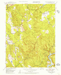
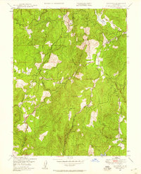
(26)- 1941 Map of Bangor, 1958 Print
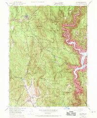
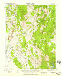 1941 Bangor1958 Print · USGSThe Butte and Yuba County foothills are captured in the early 1940s, showing a landscape of scattered mining claims and rural homesteads. Genealogists can trace family roots through several local landmarks like Upham Cem, Wyandotte Sch, and the Phoenix Mine.
 - 1942 Map of Markham Ravine
 1942 Markham Ravine1942 Print · USGSWestern Placer County was a landscape of busy rail lines and rural schoolhouses in the early 1940s. Genealogists and historians can trace old homesteads near Sheridan, locate the Clay Quarry at Lincoln, or find former community centers like Central Sch.
 - 1944 Map of Bangor
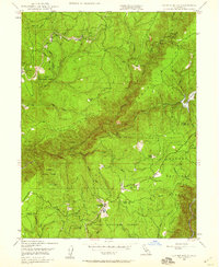
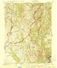 1944 Bangor1944 Print · USGSThe foothills of the Sierra Nevada are captured here during the early 1940s, showing a landscape defined by gold mining and timber production. Researchers can pinpoint long-standing landmarks such as Hansonville, the Blue Lead Mine, and several rural burial grounds like Upham Cem.2 unique versions available
 - 1947 Map of Sacramento, 1948 Print
 1947 Sacramento1948 Print · USGSThe Sacramento Valley meets the high Sierra during a period of post-war expansion. Trace the historic river delta islands like Grand Island or locate early airfield footprints at McClellan Air Force Base and Mather Air Force Base.2 unique versions available
 - 1947 Map of Loma Rica, 1956 Print
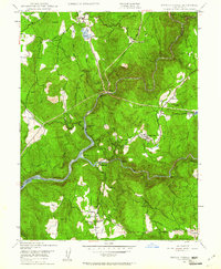
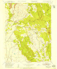 1947 Loma Rica1956 Print · USGSThe Yuba and Butte county borderlands appear in the late 1940s as a landscape of foothill ranching and legacy mining. Trace family roots at Honcut Cem or find old mining sites like the Sweet Vengeance Mine and Smethurst Mine (Abandoned).3 unique versions available
 - 1947 Map of Browns Valley, 1957 Print
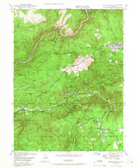
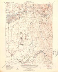
 1947 Browns Valley1957 Print · USGSYuba County in the late 1940s reveals a landscape shaped by gold dredging and military expansion. You can trace the dredge fields surrounding Hammonton and Marigold or locate historic schools and mines like the Pennsylvania Mine and Brophy Sch.5 unique versions available
 - 1947 Map of Wheatland, 1958 Print
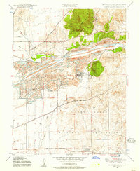
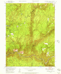
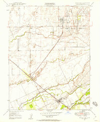 1947 Wheatland1958 Print · USGSWheatland and the surrounding ranchlands are shown shortly after the war, when the railroad and river systems dictated local commerce. Researchers can trace family-named sites like Johnson Ranch and Horstville or the early boundaries of the Camp Beale Military Reservation.4 unique versions available
 - 1948 Map of Sacramento, 1951 Print
 1948 Sacramento1951 Print · USGSPost-war Northern California comes alive in this regional survey, capturing the era of expansion between the Central Valley and the High Sierra. Researchers can trace the rail networks of the Central California Traction and Sacramento Northern RR or locate landmarks like the State Capitol and University of California Davis.
 - 1948 Map of Nevada City, 1953 Print
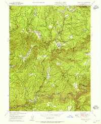
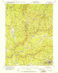 1948 Nevada City1953 Print · USGSNevada City and the Yuba River canyons are captured here in the late 1940s, just as modern reservoirs began to reshape the old gold country. Genealogists and historians can trace family-named sites like Godfrey Ranch (Pike PO), Pleasant Valley Sch, and the Nevada City Rancheria.4 unique versions available
 - 1948 Map of Big Bend Mtn, 1953 Print
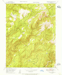
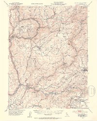 1948 Big Bend Mtn1953 Print · USGSIn the Sierra Nevada foothills during the late 1940s, this area remained a landscape of deep river canyons and historic mining camps. Genealogists and researchers can trace the old settlements of Forbestown and Enterprise, find the Indian Cemetery, or locate the Gold Bank Mine.4 unique versions available
 - 1948 Map of Mooreville Ridge, 1953 Print
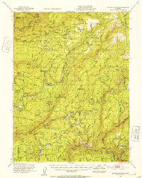 1948 Mooreville Ridge1953 Print · USGSThe northern Sierra Nevada at the end of the 1940s shows a landscape of deep canyons and timber camps. Locate family-named landmarks like McIntosh Ranch or trace the early industrial footprint of Brandy City and the Monte de Oro Mine.3 unique versions available
 - 1948 Map of Oregon House, 1956 Print
 1948 Oregon House1956 Print · USGSThe Yuba County foothills are captured here in the late 1940s, showing a landscape of family ranches and early water engineering. Genealogists can locate family landmarks like Carmichael Ranch and Virginia Ranch or the historic Peoria Sch.3 unique versions available
 - 1948 Map of American House, 1956 Print
 1948 American House1956 Print · USGSThe Plumas County high country in the late 1940s reveals a landscape of remote mountain ranches and legacy gold mines. Researchers can trace the heritage of American House, locate the Browns Hill Mine, and find family-named sites like McIntosh Ranch.3 unique versions available
 - 1948 Map of Camptonville, 1956 Print
 1948 Camptonville1956 Print · USGSTahoe National Forest's steep canyons and mining settlements are documented here just after the war. Local historians can trace the foundations of Camptonville, find the Godfrey Ranch (Pike PO), or locate remote river sites like Strawberry Bar.4 unique versions available
 - 1948 Map of Strawberry Valley, 1957 Print
 1948 Strawberry Valley1957 Print · USGSThe Sierra Nevada gold country of Yuba and Sierra Counties is captured here just after the war, showing the rugged canyons of the Yuba River. Genealogists and historians can trace the locations of Brandy City, the Palace Mine, and river settlements like Cut Eye Fosters Bar.4 unique versions available
 - 1948 Map of Rackerby, 1958 Print
 1948 Rackerby1958 Print · USGSThe foothills of the Sierra Nevada are captured here in the late 1940s as old mining claims gave way to ranching and timber. Genealogists and local historians can trace family landmarks like Rose Ranch, locate the Central Pacific Mine, and find vanished schoolhouses such as Sharon Valley Sch.4 unique versions available
 - 1948 Map of Clipper Mills, 1959 Print
 1948 Clipper Mills1959 Print · USGSThe northern Sierra timber and mining frontier is documented here just after the war. Local researchers can trace family holdings and industry through Clipper Mills, the Monte de Oro Mine, and the historic Clipper Mills School.5 unique versions available
 - 1948 Map of French Corral, 1961 Print
 1948 French Corral1961 Print · USGSThe Gold Country of Yuba and Nevada Counties comes into focus just after the war as hydroelectric power began to reshape the river canyons. Researchers can locate the San Juan Mine, the village of French Corral, and the Pleasant Valley Sch.4 unique versions available
 - 1948 Map of Forbestown, 1967 Print
 1948 Forbestown1967 Print · USGSThe Sierra foothills in the late 1940s show a landscape shaped by water and gold mining. Genealogists and researchers can trace the historic locations of Old Forbestown, the Indian Cemetery, and several mining sites like the Gold Bank Mine.
 - 1948 Map of Challenge, 1971 Print
 1948 Challenge1971 Print · USGSThe foothills of the Sierra Nevada are shown here just as the Bullards Bar Reservoir began to reshape the Yuba River canyon in the late sixties. Researchers can trace historic family lands like Indiana Ranch alongside mining operations including the Red Cross Mine and Horseshoe Mine.4 unique versions available
 - 1949 Map of Wheatland
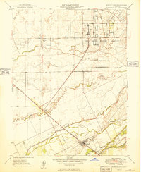 1949 Wheatland1949 Print · USGSWheatland and the surrounding agricultural landscape are shown here in the late 1940s as the regional economy balanced ranching with military development. Researchers can trace family-named lands like Boardman Ranch and Durst Ranch, or explore the wartime footprint of the Camp Beale Military Reservation.
 - 1949 Map of Loma Rica
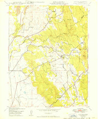 1949 Loma Rica1949 Print · USGSThe foothills of Yuba and Butte counties come alive in the late 1940s, showing a landscape shaped by irrigation and gold-era mining. Genealogists can locate family landmarks like Honcut Cem, Kings Sch, and the curious Stone House settlement.
 - 1949 Map of Browns Valley
 1949 Browns Valley1949 Print · USGSYuba County during the late 1940s reveals a landscape defined by hydraulic engineering and the massive footprint of wartime mobilization. You can trace the development of Hammonton and Marigold alongside the Camp Beale Military Reservation and historic mines like the Pennsylvania Mine.2 unique versions available
 - 1949 Map of Wheatland, 1953 Print
 1949 Wheatland1953 Print · USGSYuba and Nevada counties appear here during the postwar transition of the late 1940s, showing a landscape defined by massive gold dredging and military expansion. Genealogists and historians can trace the foundations of Camp Beale Military Reservation or locate early mining sites like Timbuctoo and the Pennsylvania Mine.3 unique versions available
 - 1949 Map of Smartville, 1956 Print
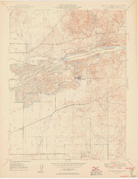
 1949 Smartville1956 Print · USGSYuba County’s gold-bearing foothills are captured here in the late 1940s as military and ranching interests reshaped the mining landscape. Genealogists can locate family holdings like Bonanza Ranch and Forbes Ranch or trace the early foundations of the Camp Beale Military Reservation.
Showing maps 1-25 of 26
Top cities of Yuba County
- Linda historical maps
- Olivehurst historical maps
- Marysville historical maps
- Plumas Lake historical maps
- Wheatland historical maps
Frequently asked questions
- What are the different types of historical maps available for Yuba County?
- What is the oldest map of Yuba County?
- Where can I purchase historical maps of Yuba County for my home or office?
- Where can I download high-res historical maps of Yuba County?
- Are there historical topographic maps available for Yuba County?
- Is there historical aerial imagery available for Yuba County?
- Where are historical maps of Yuba County sourced from?