1910s Maps of Yuba County, California
Explore 11 historic maps of Yuba County from the 1910s. These maps offer a rare glimpse into what life looked like during the 1910s — showing old roads, neighborhoods, homes, and landmarks that have changed or disappeared over time.
Whether you're researching your family's past, planning a metal detecting trip, or studying how Yuba County's landscape evolved across the 1910s, these high-resolution maps are a powerful tool for exploring the history of this region.
- Focus on a specific era: All maps on this page are from the 1910s, giving you a focused view of this time period.
- See what’s changed: Compare century-old streets, trails, and buildings to today's modern landscape using overlays and satellite layers.
- Research with precision: Use these maps for genealogy, historical research, land use analysis, or educational projects.
- View, download, or print: Maps are fully viewable online in high resolution, and can be downloaded or printed for your own records.
Start exploring Yuba County's history through authentic maps from the 1910s. This is your window into the past.
Yuba County, CA maps
(11)- 1910 Map of Sheridan
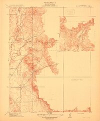
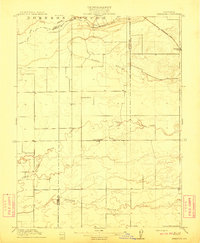 1910 Sheridan1910 Print · USGSNear the Placer and Sutter county line in the early 1900s, this area was a landscape of historic land grants and vital rail links. Genealogists and historians can trace the tracks of the S. P. R. R. (Marysville Line) past Sheridan and locate the rural Fairview School.2 unique versions available
 - 1910 Map of Wheatland
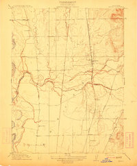
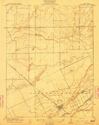 1910 Wheatland1910 Print · USGSThe Wheatland area at the dawn of the twentieth century was a landscape of expansive ranching lands and developing rail corridors. Researchers can trace the massive Johnson Rancho boundary, locate the Eagle School, and find the early settlement of Horstville.2 unique versions available
 - 1910 Map of Nicolaus
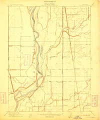 1910 Nicolaus1910 Print · USGSSutter County thrives at the junction of the Feather and Bear rivers during the early 1900s rail expansion. Genealogy and local history researchers can trace old rail stops at Nicolaus Sta and Rio Oso or locate landmarks like the Illinois School.2 unique versions available
 - 1911 Map of Sutter
 1911 Sutter1911 Print · USGSAgricultural life in the Sacramento Valley thrived during the early 1900s, anchored by the iconic Marysville Buttes. Genealogists and historians can trace the local school districts of Liveoak School and Washington School or locate rail stops at Nuestro and Encinal.
 - 1911 Map of Browns Valley
 1911 Browns Valley1911 Print · USGSThe gold country of Yuba County is captured here in the early twentieth century. Family historians and researchers can trace old road networks like the Wheatland Road and locate early rural sites such as Hammonton and Brophy School.
 - 1911 Map of Yuba City
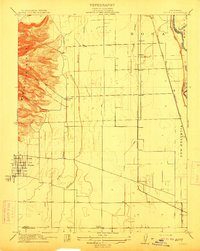
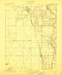
 1911 Yuba City1911 Print · USGSThe confluence of the Feather and Yuba Rivers comes to life in the early twentieth century, showing a region deeply tied to its rail and water networks. Genealogists and historians can trace the exact 1909 footprints of Marysville, Woodruff School, and the Southern Pacific RR.2 unique versions available
 - 1911 Map of Ostrom
 1911 Ostrom1911 Print · USGSThe Yuba County lowlands were a hub of competing rail lines and river transport in the years before the Great War. Genealogists can trace family footprints near Ella School, the stop at Alicia, or the historic wetlands of Plumas Lake.
 - 1912 Map of Prairie Creek
 1912 Prairie Creek1912 Print · USGSThe foothills of Yuba and Butte counties come alive in this pre-war survey of the Sacramento Valley’s eastern edge. Genealogists and historians can trace the routes of Bangor Road and locate the historic Salem School and Buckeye School near the banks of Prairie Creek.3 unique versions available
 - 1912 Map of Honcut
 1912 Honcut1912 Print · USGSThe rural borderlands of Butte and Yuba counties come into focus at the height of the steam rail era. Researchers can trace the legacy of early valley education and transport through local landmarks like Central School, the village of Honcut, and the tracks of the Southern Pacific.
 - 1912 Map of Gridley
 1912 Gridley1912 Print · USGSThe Sacramento Valley at the height of its early rail-and-canal era reveals a landscape of planned agricultural colonies and riverfront commerce. Genealogists and local historians can trace the growth of Gridley and Liveoak alongside early schools like Manzanito School.
 - 1915 Map of Spenceville
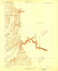 1915 Spenceville1915 Print · USGSIn the California foothills before the era of major dams, the Bear River and Johnson Rancho defined the local landscape. Genealogists and historians can trace old property lines and river landmarks like McCourtney Crossing and Fenton Ravine.2 unique versions available
End of results
Showing maps 1-11 of 11
Top cities of Yuba County
- Linda historical maps
- Olivehurst historical maps
- Marysville historical maps
- Plumas Lake historical maps
- Wheatland historical maps
Frequently asked questions
- What are the different types of historical maps available for Yuba County?
- What is the oldest map of Yuba County?
- Where can I purchase historical maps of Yuba County for my home or office?
- Where can I download high-res historical maps of Yuba County?
- Are there historical topographic maps available for Yuba County?
- Is there historical aerial imagery available for Yuba County?
- Where are historical maps of Yuba County sourced from?