1970s Maps of Arapahoe County, Colorado
Explore 4 historic maps of Arapahoe County from the 1970s. These maps offer a rare glimpse into what life looked like during the 1970s — showing old roads, neighborhoods, homes, and landmarks that have changed or disappeared over time.
Whether you're researching your family's past, planning a metal detecting trip, or studying how Arapahoe County's landscape evolved across the 1970s, these high-resolution maps are a powerful tool for exploring the history of this region.
- Focus on a specific era: All maps on this page are from the 1970s, giving you a focused view of this time period.
- See what’s changed: Compare century-old streets, trails, and buildings to today's modern landscape using overlays and satellite layers.
- Research with precision: Use these maps for genealogy, historical research, land use analysis, or educational projects.
- View, download, or print: Maps are fully viewable online in high resolution, and can be downloaded or printed for your own records.
Start exploring Arapahoe County's history through authentic maps from the 1970s. This is your window into the past.
Arapahoe County, CO maps
(4)- 1973 Map of Last Chance SW, 1976 Print
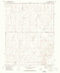 1973 Last Chance SW1976 Print · USGSThe eastern Colorado plains during the early 1970s are revealed here at the four-county junction of Arapahoe, Washington, Elbert, and Lincoln. Researchers can trace rural landmarks like Brooks Ranch and the winding course of Middlemist Creek across this high-country landscape.
 - 1973 Map of Cottonwood Valley South, 1976 Print
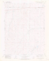
 1973 Cottonwood Valley South1976 Print · USGSThe Colorado high plains of the early seventies are defined here by a network of ranch lands and essential watercourses. Researchers can trace the boundary between Arapahoe Co and Elbert Co while locating landmarks like Cross J Ranch and Rattlesnake Creek.
 - 1973 Map of Last Chance NW, 1976 Print
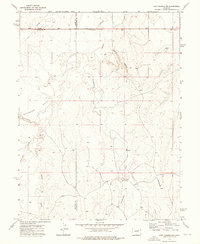 1973 Last Chance NW1976 Print · USGSThe High Plains of Eastern Colorado are captured here in the early 1970s as agricultural life centered on the tri-county border. Genealogists and researchers can trace local landmarks like Prairie Farms, the Landing Strip, and the winding Beaver Creek.
 - 1973 Map of Cottonwood Valley North, 1976 Print
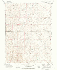
 1973 Cottonwood Valley North1976 Print · USGSThe high plains at the Adams and Arapahoe county line are captured here in the early seventies, showing a landscape of ranching and energy. Genealogists and historians can locate the Arrow K Ranch and trace the paths of Badger Creek and Rattlesnake Creek.
End of results
Showing maps 1-4 of 4
Top cities of Arapahoe County
- Centennial historical maps
- Littleton historical maps
- Englewood historical maps
- Greenwood Village historical maps
- Cherry Hills Village historical maps
- Sheridan historical maps
See more
Frequently asked questions
- What are the different types of historical maps available for Arapahoe County?
- What is the oldest map of Arapahoe County?
- Where can I purchase historical maps of Arapahoe County for my home or office?
- Where can I download high-res historical maps of Arapahoe County?
- Are there historical topographic maps available for Arapahoe County?
- Is there historical aerial imagery available for Arapahoe County?
- Where are historical maps of Arapahoe County sourced from?