1960s Maps of Baca County, Colorado
Explore 6 historic maps of Baca County from the 1960s. These maps offer a rare glimpse into what life looked like during the 1960s — showing old roads, neighborhoods, homes, and landmarks that have changed or disappeared over time.
Whether you're researching your family's past, planning a metal detecting trip, or studying how Baca County's landscape evolved across the 1960s, these high-resolution maps are a powerful tool for exploring the history of this region.
- Focus on a specific era: All maps on this page are from the 1960s, giving you a focused view of this time period.
- See what’s changed: Compare century-old streets, trails, and buildings to today's modern landscape using overlays and satellite layers.
- Research with precision: Use these maps for genealogy, historical research, land use analysis, or educational projects.
- View, download, or print: Maps are fully viewable online in high resolution, and can be downloaded or printed for your own records.
Start exploring Baca County's history through authentic maps from the 1960s. This is your window into the past.
Baca County, CO maps
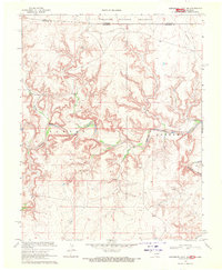
(6)- 1962 Map of Dalhart
 1962 Dalhart1962 Print · USGSThe High Plains and volcanic peaks of the tri-state area are shown in detail during the early sixties. Genealogists and historians can trace the rail corridors of the Fort Worth and Denver and find industrial sites like the Cactus Ordnance Works or the Beaver Meade & Englewood Grain Elevator.
 - 1968 Map of La Junta
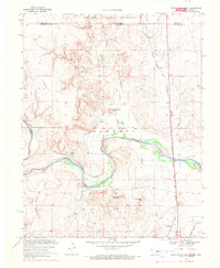
 1968 La Junta1968 Print · USGSSoutheastern Colorado and the high plains appear in remarkable detail during the late 1960s, showing the intersection of irrigation, ranching, and rail. Genealogists can trace family footprints at the Lycan Post Office, Konantz Cem, and across numerous named cattle ranches.
 - 1968 Map of Autograph Cliff NW, 1971 Print
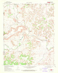
 1968 Autograph Cliff NW1971 Print · USGSThe Oklahoma-Colorado borderlands come alive in this late-sixties survey of the Cimarron River valley. Genealogists and historians can trace the rugged topography of the Kenton region, locating a small Cem and the reaches of the Comanche National Grassland.
 - 1968 Map of Kenton, 1971 Print
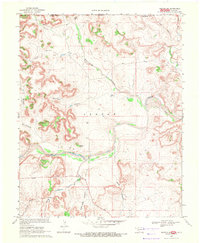
 1968 Kenton1971 Print · USGSKenton and the high mesa country of the Oklahoma Panhandle are documented here during the late sixties. Researchers can trace the unique topography of the tri-state border area, locating landmarks like the Kenton Cem, Robbers Roost Peak, and Coopers Trail.3 unique versions available
 - 1969 Map of Kenton NE, 1971 Print
 1969 Kenton NE1971 Print · USGSThe Oklahoma Panhandle and Colorado borderlands meet along the river in the late sixties. Researchers can trace the rugged drainage of Gallinas Canon and Carrizo Creek or locate landmarks like Castle Rock and the local Cem.
 - 1969 Map of Razor Blade Mesa, 1971 Print
 1969 Razor Blade Mesa1971 Print · USGSThe Oklahoma Panhandle's Cimarron River valley is mapped here in the late sixties as the high mesas meet the state line. Genealogists and local historians can locate the Garrett Cemetery, the railroad stop at Castaneda, and the tracks of the Atchison Topeka and Santa Fe.
End of results
Showing maps 1-6 of 6
Top cities of Baca County
- Springfield historical maps
- Walsh historical maps
- Campo historical maps
- Pritchett historical maps
- Vilas historical maps
- Two Buttes historical maps
Frequently asked questions
- What are the different types of historical maps available for Baca County?
- What is the oldest map of Baca County?
- Where can I purchase historical maps of Baca County for my home or office?
- Where can I download high-res historical maps of Baca County?
- Are there historical topographic maps available for Baca County?
- Is there historical aerial imagery available for Baca County?
- Where are historical maps of Baca County sourced from?