1900-1909 Maps of Boulder County, Colorado
Explore 9 historic maps of Boulder County from 1900-1909. These maps offer a rare glimpse into what life looked like during the 1900s — showing old roads, neighborhoods, homes, and landmarks that have changed or disappeared over time.
Whether you're researching your family's past, planning a metal detecting trip, or studying how Boulder County's landscape evolved across the 1900s, these high-resolution maps are a powerful tool for exploring the history of this region.
- Focus on a specific era: All maps on this page are from the 1900s, giving you a focused view of this time period.
- See what’s changed: Compare century-old streets, trails, and buildings to today's modern landscape using overlays and satellite layers.
- Research with precision: Use these maps for genealogy, historical research, land use analysis, or educational projects.
- View, download, or print: Maps are fully viewable online in high resolution, and can be downloaded or printed for your own records.
Start exploring Boulder County's history through authentic maps from the 1900s. This is your window into the past.
Boulder County, CO maps
(9)- 1902 Map of Boulder, 1957 Print
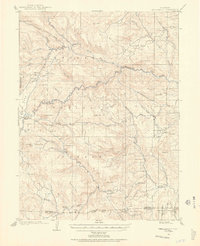
 1902 Boulder1957 Print · USGSThe Front Range foothills hum with mining and rail activity at the turn of the century. Genealogy researchers can trace families in old mining camps like Gold Hill, Wallstreet, and Sunshine, or follow the winding Colorado and Northwestern RR.
 - 1904 Map of Niwot
 1904 Niwot1904 Print · USGSThe northern Colorado plains come alive in the early 1900s, showcasing a landscape shaped by coal mining and extensive irrigation. Genealogists and historians can trace family roots through settlements like Hygiene, Niwot, and Erie, or locate industrial sites such as Dixon Mill and the Gladstone Mine.3 unique versions available
 - 1904 Map of Boulder
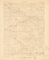
 1904 Boulder1904 Print · USGSThe Front Range foothills hum with mining activity at the start of the twentieth century, as narrow-gauge rails climb the canyons. Genealogists and historians can trace defunct rail stops and mining camps like Salina, Wallstreet, and Gold Hill Sta..6 unique versions available
 - 1905 Map of Central City
 1905 Central City1905 Print · USGSThe Colorado Front Range is captured here at the peak of its early mining era, showing the dense network of gulches and camps. Trace historic mining operations at Central City, follow the high-mountain route of the Denver Northwestern and Pacific RR, or locate vanished settlements like Baltimore and Perigo.
 - 1905 Map of Mount Olympus, 1955 Print
 1905 Mount Olympus1955 Print · USGSLarimer County mountain life is captured here at the turn of the century as early ranching and tourism began to define the canyons. Genealogists and historians can trace family-held lands such as Pflums Ranch, stay at the Rustic Hotel, or locate the now-submerged site of Pinewood.2 unique versions available
 - 1906 Map of Blackhawk
 1906 Blackhawk1906 Print · USGSThe Front Range foothills and mining districts come alive in this early century survey, showing the transition from mountain ranching to industrial rail. Genealogists and historians can trace family holdings like Winiger Ranch, find the Pine Glade School, and follow the Denver Northwestern and Pacific RR.5 unique versions available
 - 1906 Map of Loveland, 1954 Print
 1906 Loveland1954 Print · USGSThe Colorado plains meet the Front Range in the early 1900s, showing a landscape transformed by early irrigation and rail. Genealogists can trace family names across Loveland and Berthoud or locate rural sites like Masonville and Benson Lake.5 unique versions available
 - 1907 Map of Mount Olympus
 1907 Mount Olympus1907 Print · USGSLarimer County at the turn of the century shows a landscape of early cattle ranches and mountain retreats along the Thompson River. Genealogists can trace family holdings at the Plum's Ranch and Miners Ranch or locate the historic Rustic Hotel and Noland rail stop.4 unique versions available
 - 1908 Map of Loveland
 1908 Loveland1908 Print · USGSThe Front Range foothills of Larimer County come alive in this early 1900s survey, showing a landscape transformed by water engineering and rail. Trace the original irrigation lines like Louden Ditch and find early industrial sites like the Plaster Mill.7 unique versions available
End of results
Showing maps 1-9 of 9
Top cities of Boulder County
- Boulder historical maps
- Longmont historical maps
- Lafayette historical maps
- Louisville historical maps
- Lyons historical maps
- Nederland historical maps
See more
Frequently asked questions
- What are the different types of historical maps available for Boulder County?
- What is the oldest map of Boulder County?
- Where can I purchase historical maps of Boulder County for my home or office?
- Where can I download high-res historical maps of Boulder County?
- Are there historical topographic maps available for Boulder County?
- Is there historical aerial imagery available for Boulder County?
- Where are historical maps of Boulder County sourced from?