Old Maps of Boulder County, Colorado for Metal Detecting
Plan your next treasure hunt with 193 historic maps of Boulder County. Find old homesites, ghost towns, trails, and gathering spots that may be lost to time — perfect for identifying promising metal detecting locations.
- Locate forgotten sites: Uncover places like long-lost settlements, abandoned rail lines, or gathering spots.
- Plan better hunts: Use map overlays combined with LiDAR or satellite views to narrow in on historically rich areas.
- Made for detectorists: Thousands of hobbyists use these maps to discover relics, coins, and hidden history.
Use these historic maps to boost your research and find new opportunities beneath the surface of Boulder County.
Boulder County, CO maps
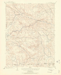
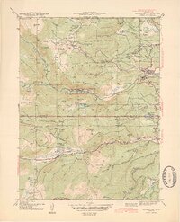
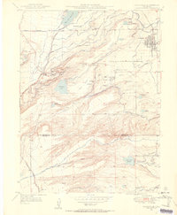
(193)- 1899 Map of West Denver
 1899 West Denver1899 Print · USGSThe Denver metropolitan area and its western foothills appear in the late Victorian era as a burgeoning rail and irrigation hub. Researchers can trace the early footprints of Denver, Golden, and Littleton, alongside industrial sites like the Louisville Coal Mine and the grounds of Fort Logan.
 - 1902 Map of Boulder, 1957 Print
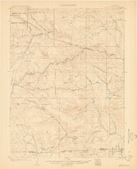
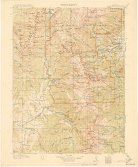
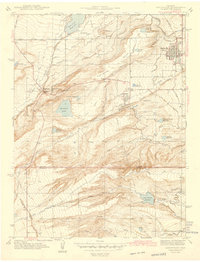
 1902 Boulder1957 Print · USGSThe Front Range foothills hum with mining and rail activity at the turn of the century. Genealogy researchers can trace families in old mining camps like Gold Hill, Wallstreet, and Sunshine, or follow the winding Colorado and Northwestern RR.
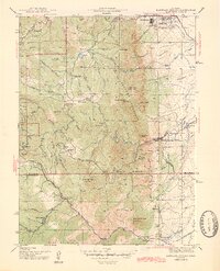
 - 1904 Map of Niwot
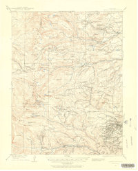
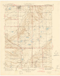
 1904 Niwot1904 Print · USGSThe northern Colorado plains come alive in the early 1900s, showcasing a landscape shaped by coal mining and extensive irrigation. Genealogists and historians can trace family roots through settlements like Hygiene, Niwot, and Erie, or locate industrial sites such as Dixon Mill and the Gladstone Mine.3 unique versions available
 - 1904 Map of Boulder
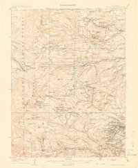
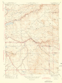
 1904 Boulder1904 Print · USGSThe Front Range foothills hum with mining activity at the start of the twentieth century, as narrow-gauge rails climb the canyons. Genealogists and historians can trace defunct rail stops and mining camps like Salina, Wallstreet, and Gold Hill Sta..6 unique versions available
 - 1905 Map of Central City
 1905 Central City1905 Print · USGSThe Colorado Front Range is captured here at the peak of its early mining era, showing the dense network of gulches and camps. Trace historic mining operations at Central City, follow the high-mountain route of the Denver Northwestern and Pacific RR, or locate vanished settlements like Baltimore and Perigo.
 - 1905 Map of Mount Olympus, 1955 Print
 1905 Mount Olympus1955 Print · USGSLarimer County mountain life is captured here at the turn of the century as early ranching and tourism began to define the canyons. Genealogists and historians can trace family-held lands such as Pflums Ranch, stay at the Rustic Hotel, or locate the now-submerged site of Pinewood.2 unique versions available
 - 1906 Map of Blackhawk
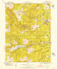
 1906 Blackhawk1906 Print · USGSThe Front Range foothills and mining districts come alive in this early century survey, showing the transition from mountain ranching to industrial rail. Genealogists and historians can trace family holdings like Winiger Ranch, find the Pine Glade School, and follow the Denver Northwestern and Pacific RR.5 unique versions available
 - 1906 Map of Loveland, 1954 Print
 1906 Loveland1954 Print · USGSThe Colorado plains meet the Front Range in the early 1900s, showing a landscape transformed by early irrigation and rail. Genealogists can trace family names across Loveland and Berthoud or locate rural sites like Masonville and Benson Lake.5 unique versions available
 - 1907 Map of Mount Olympus
 1907 Mount Olympus1907 Print · USGSLarimer County at the turn of the century shows a landscape of early cattle ranches and mountain retreats along the Thompson River. Genealogists can trace family holdings at the Plum's Ranch and Miners Ranch or locate the historic Rustic Hotel and Noland rail stop.4 unique versions available
 - 1908 Map of Loveland
 1908 Loveland1908 Print · USGSThe Front Range foothills of Larimer County come alive in this early 1900s survey, showing a landscape transformed by water engineering and rail. Trace the original irrigation lines like Louden Ditch and find early industrial sites like the Plaster Mill.7 unique versions available
 - 1910 Map of Central City, 1957 Print
 1910 Central City1957 Print · USGSThe Colorado high country at the start of the century reveals a landscape defined by mining booms and engineering marvels. Trace the intricate rail networks of the Colorado Southern RR or locate family roots in the historic camps of Nevadaville and Central City.2 unique versions available
 - 1912 Map of Central City
 1912 Central City1912 Print · USGSThe Colorado Front Range mining districts were in full operation during this era of deep-shaft extraction and mountain railroading. Researchers can trace the industrial footprint of Central City, locate the Boulder County Mine, and follow the path of the Colorado and Southern RR through the gulches.4 unique versions available
 - 1915 Map of Longs Peak
 1915 Longs Peak1915 Print · USGSHigh mountain passes and early alpine settlements define this region just as the National Park system was taking root. Genealogists and hikers can trace the Ute Trail, locate the Sleepy Hollow School, or find the old Monarch PO near Grand Lake.3 unique versions available
 - 1919 Map of Rocky Mountain National Park
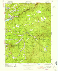
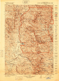 1919 Rocky Mountain National Park1919 Print · USGSThe high alpine basins of Northern Colorado are captured here in the years following the park's creation. Researchers can locate early schools and post offices like Sleepy Hollow School and Monarch PO, or trace the rail lines of the Denver and Salt Lake RR.7 unique versions available
 - 1940 Map of Lafayette
 1940 Lafayette1940 Print · USGSLafayette and the northern Colorado coalfields are captured in the late 1930s as mining and rail transport shaped the local economy. Genealogists can trace family roots through named landmarks like Mandalay Sch, Lakeview Cem, and the Centennial Mine.
 - 1942 Map of Eldorado Springs
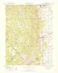 1942 Eldorado Springs1942 Print · USGSJust before the mid-century, the mountain interface west of Boulder was a landscape of remote ranches and rugged rail lines. Trace the early settlement of Eldorado Springs and find vanished landmarks like the Pine Grove Sch and the Coal Creek Store.4 unique versions available
 - 1942 Map of Louisville
 1942 Louisville1942 Print · USGSLouisville and the high plains of Boulder County are captured here just before the mid-century expansion. Genealogists and historians can trace the early footprints of Superior, Marshall, and Louisville, or locate rural landmarks like the Sacred Heart Ch and Shamrock Sch.3 unique versions available
 - 1942 Map of Nederland, 1954 Print
 1942 Nederland1954 Print · USGSThe Colorado Front Range comes alive in the early 1940s, showing the intersection of high-mountain mining and railroad engineering. Genealogists and historians can trace the foundations of Nederland, the old mining works at Caribou, and the tracks of the Denver and Salt Lake near Tolland.6 unique versions available
 - 1942 Map of Tungsten, 1955 Print
 1942 Tungsten1955 Print · USGSBoulder and Gilpin counties come alive in the 1940s as mining and mountain ranching define the high-country landscape. Genealogists and historians can trace the Denver and Salt Lake rail line through Pinecliffe P O and find remote sites like the Kekionga Mine.5 unique versions available
 - 1944 Map of Lafayette
 1944 Lafayette1944 Print · USGSThe northern Front Range in the years following the Great Depression was a landscape of coal mines and intricate irrigation reservoirs. You can trace the early footprints of Lafayette and Broomfield while locating industrial landmarks like the Centennial Mine and Burn Lee Sch.
 - 1944 Map of Nederland
 1944 Nederland1944 Print · USGSNederland and the mining districts of Boulder and Gilpin Counties are shown here during the early 1940s. Genealogists and historians can trace the legacy of high-country industry through the Denver and Salt Lake rail line and sites like the Zarlengo Saw Mill or Caribou.2 unique versions available
 - 1944 Map of Eldorado Springs
 1944 Eldorado Springs1944 Print · USGSThe Front Range foothills in the 1940s reveal a landscape of mountain ranches and deep canyons just south of Boulder. Genealogists and hikers can trace old homesteads like Walker Ranch, the winding Denver and Salt Lake RR, and early landmarks such as the Copeland Mine.2 unique versions available
 - 1944 Map of Tungsten
 1944 Tungsten1944 Print · USGSBoulder and Gilpin counties are captured here in the mid-1940s, as mountain railroads and mining operations shaped the Front Range. Genealogists can trace family footprints at Lincoln Hills, Pine Glade Sch, and the Kekionga Mine.
 - 1950 Map of Hygiene, 1952 Print
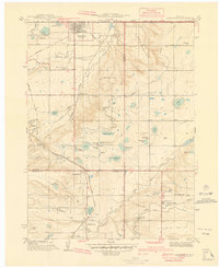
 1950 Hygiene1952 Print · USGSThe Boulder County plains meet the foothills in the mid-twentieth century, revealing a landscape shaped by intricate irrigation and early ranching. Genealogists can trace family footprints at the Ryssby Ch, the settlement of Altona, and several rural schoolhouses like Montgomery School.5 unique versions available
 - 1950 Map of Louisville, 1955 Print
 1950 Louisville1955 Print · USGSThe Boulder Valley coal fields and irrigation networks are on full display in the mid-twentieth century. Researchers can trace dozens of mining sites like the Eldorado Mine, find the Superior Cemetery, and locate rural schools including Marshall Sch.
Showing maps 1-25 of 193
Top cities of Boulder County
- Boulder historical maps
- Longmont historical maps
- Lafayette historical maps
- Louisville historical maps
- Lyons historical maps
- Nederland historical maps
See more
Frequently asked questions
- What are the different types of historical maps available for Boulder County?
- What is the oldest map of Boulder County?
- Where can I purchase historical maps of Boulder County for my home or office?
- Where can I download high-res historical maps of Boulder County?
- Are there historical topographic maps available for Boulder County?
- Is there historical aerial imagery available for Boulder County?
- Where are historical maps of Boulder County sourced from?