1940s Maps of Chaffee County, Colorado
Explore 3 historic maps of Chaffee County from the 1940s. These maps offer a rare glimpse into what life looked like during the 1940s — showing old roads, neighborhoods, homes, and landmarks that have changed or disappeared over time.
Whether you're researching your family's past, planning a metal detecting trip, or studying how Chaffee County's landscape evolved across the 1940s, these high-resolution maps are a powerful tool for exploring the history of this region.
- Focus on a specific era: All maps on this page are from the 1940s, giving you a focused view of this time period.
- See what’s changed: Compare century-old streets, trails, and buildings to today's modern landscape using overlays and satellite layers.
- Research with precision: Use these maps for genealogy, historical research, land use analysis, or educational projects.
- View, download, or print: Maps are fully viewable online in high resolution, and can be downloaded or printed for your own records.
Start exploring Chaffee County's history through authentic maps from the 1940s. This is your window into the past.
Chaffee County, CO maps
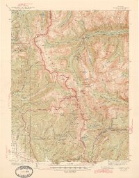
(3)- 1940 Map of Garfield, 1954 Print
 1940 Garfield1954 Print · USGSThe high Sawatch Range is seen here at the peak of its industrial mining era, straddling the Continental Divide. Genealogists and historians can trace defunct mountain rail routes and remote settlements like St Elmo, Hancock, and the historic Old Alpine Tunnel.6 unique versions available
 - 1942 Map of Leadville, 1943 Print
 1942 Leadville1943 Print · USGSHigh in the Rockies during the early war years, this area served as a critical hub for military training and mining operations. Trace the rail lines of the Denver and Rio Grande Western RR and find local landmarks like the U. S. Fish Hatchery or the Adelaide mine.
 - 1945 Map of Garfield
 1945 Garfield1945 Print · USGSThe high Sawatch Range and its historic mining districts appear here in the mid-1940s, just as many remote camps were reaching a quiet maturity. Genealogists and historians can trace the steep paths to St Elmo, the OLD ALPINE TUNNEL, and active sites like the GARFIELD MINE.2 unique versions available
End of results
Showing maps 1-3 of 3
Top cities of Chaffee County
- Salida historical maps
- Buena Vista historical maps
- Poncha Springs historical maps
- Nathrop historical maps
- Alpine historical maps
- Smeltertown historical maps
Frequently asked questions
- What are the different types of historical maps available for Chaffee County?
- What is the oldest map of Chaffee County?
- Where can I purchase historical maps of Chaffee County for my home or office?
- Where can I download high-res historical maps of Chaffee County?
- Are there historical topographic maps available for Chaffee County?
- Is there historical aerial imagery available for Chaffee County?
- Where are historical maps of Chaffee County sourced from?