1950s Maps of Chaffee County, Colorado
Explore 15 historic maps of Chaffee County from the 1950s. These maps offer a rare glimpse into what life looked like during the 1950s — showing old roads, neighborhoods, homes, and landmarks that have changed or disappeared over time.
Whether you're researching your family's past, planning a metal detecting trip, or studying how Chaffee County's landscape evolved across the 1950s, these high-resolution maps are a powerful tool for exploring the history of this region.
- Focus on a specific era: All maps on this page are from the 1950s, giving you a focused view of this time period.
- See what’s changed: Compare century-old streets, trails, and buildings to today's modern landscape using overlays and satellite layers.
- Research with precision: Use these maps for genealogy, historical research, land use analysis, or educational projects.
- View, download, or print: Maps are fully viewable online in high resolution, and can be downloaded or printed for your own records.
Start exploring Chaffee County's history through authentic maps from the 1950s. This is your window into the past.
Chaffee County, CO maps
(15)- 1954 Map of Pueblo, 1966 Print
 1954 Pueblo1966 Print · USGSMid-century Colorado comes alive in this survey of the Front Range and the high plains as the region expanded after the war. Genealogists and historians can trace family roots through rural landmarks like Hanover Church, Pioneer Cemetery, and the Grandview School.3 unique versions available
 - 1955 Map of Buena Vista, 1957 Print
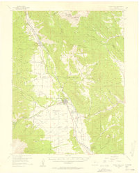 1955 Buena Vista1957 Print · USGSThe Upper Arkansas River Valley is captured here in the mid-fifties as it balances ranching, transit, and state institutions. Genealogists and historians can locate the Mt Olivet Cemetery, the Little Annie Mine, and rural schools like the Pine Creek School.8 unique versions available
 - 1955 Map of Mount Harvard, 1958 Print
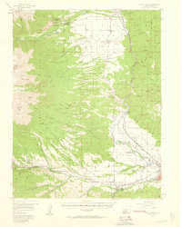
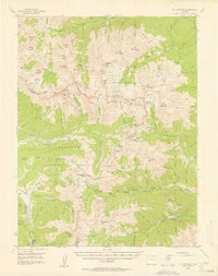 1955 Mount Harvard1958 Print · USGSThe high peaks of the Sawatch Range are captured here in the mid-1950s at the height of their mining and forest service era. Genealogists and historians can trace the remote settlements of Winfield, Vicksburg, and Tincup, or locate the Banker Mine and Magdalene Mine.4 unique versions available
 - 1956 Map of Antero Reservoir, 1957 Print
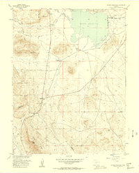 1956 Antero Reservoir1957 Print · USGSSouth Park's high-plateau ranching and rail history come alive in the mid-fifties, centered on the Antero Reservoir. Researchers can trace the Old Grade Railroad or locate family sites like Salt Works Ranch and the settlement at Haver.4 unique versions available
 - 1956 Map of Cameron Mountain, 1959 Print
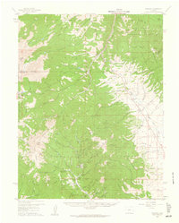
 1956 Cameron Mountain1959 Print · USGSThe Arkansas River valley near Salida and Cleora is shown here in the mid-fifties as the local mining and rail economy thrived. Researchers can trace the DENVER AND RIO GRANDE WESTERN line, the remote Oklahoma A & M Engineering Camp, and the Golden Wonder Mine.4 unique versions available
 - 1956 Map of Poncha Springs, 1959 Print
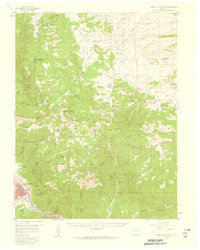
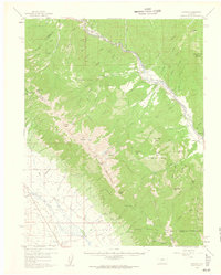
 1956 Poncha Springs1959 Print · USGSThe Arkansas River valley comes alive in the mid-1950s, showing the intersection of mountain ranching, early tourism, and the Denver and Rio Grande Western Railroad. Trace local history through Smeltertown, Maysville, and rural landmarks like the Valley View Sch.6 unique versions available
 - 1956 Map of Montrose, 1963 Print
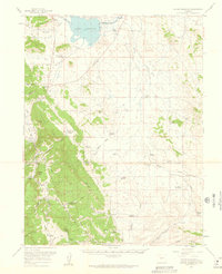
 1956 Montrose1963 Print · USGSThe Colorado western slope in the late fifties and early sixties shows a landscape defined by the Denver & Rio Grande Western RR and the Gunnison River. Trace the development of Blue Mesa Reservoir or locate high-country sites like the Bachelor Mine.3 unique versions available
 - 1957 Map of Pueblo
 1957 Pueblo1957 Print · USGSMid-century Colorado comes alive as the Front Range urban centers expand alongside massive Cold War military installations. Genealogists and historians can trace the foundations of Stone City, rural sites like Hanover School, and the industrial Canon Imperial Mine.
 - 1957 Map of Leadville, 1978 Print
 1957 Leadville1978 Print · USGSHigh-country mining and rail transport define the central Colorado Rockies during the mid-to-late twentieth century. Researchers can trace the industrial footprints of Gilman and Climax, find small rail stops like Malta, and follow the Denver and Rio Grande Western RR.2 unique versions available
 - 1958 Map of Pueblo
 1958 Pueblo1958 Print · USGSColorado's Front Range and Arkansas River Valley come alive in the late fifties, showing the transition from historic mining districts to major military and rail hubs. Genealogists and historians can trace family roots in ranching communities and find landmarks like Cripple Creek, Manitou, and the Hanover School.
 - 1959 Map of Leadville
 1959 Leadville1959 Print · USGSThe Colorado high country in the late fifties is a landscape of mining history and military training, from the streets of Leadville to the Camp Hale grounds. Genealogists and historians can trace the Denver and Rio Grande Western RR alongside now-deserted sites like Ashcroft and Independence.
 - 1959 Map of Montrose
 1959 Montrose1959 Print · USGSWestern Colorado in the late fifties is defined by the high peaks and river valleys of the Southern Rockies. Genealogists and historians can trace the paths of the Denver & Rio Grande Western RR or locate mountain settlements like Crawford, Lazear, and Doyleville.
 - 1959 Map of Bonanza, 1961 Print
 1959 Bonanza1961 Print · USGSSaguache County's rugged mining corridors are captured here in the late fifties as the regional silver and lead industries matured. Genealogists and historians can trace the foundations of Bonanza, the former townsite at Sedgwick, and numerous working claims like the Rawley Mine.5 unique versions available
 - 1959 Map of Antero Reservoir, 1961 Print
 1959 Antero Reservoir1961 Print · USGSHigh mountain ranching and homesteading in the South Park basin are preserved here in the late fifties. Genealogists can trace family lands such as the Ardleman Homestead and Salt Works Ranch or locate the historic Trump (Site).3 unique versions available
 - 1959 Map of Howard, 1961 Print
 1959 Howard1961 Print · USGSThe Arkansas River valley in the late fifties was a vital corridor for the Denver and Rio Grande Western Railroad and local mining operations. Genealogists and historians can locate the Stout Creek Sch, Union Ch, and several family cemeteries including Villa Grove Cem.6 unique versions available
End of results
Showing maps 1-15 of 15
Top cities of Chaffee County
- Salida historical maps
- Buena Vista historical maps
- Poncha Springs historical maps
- Nathrop historical maps
- Alpine historical maps
- Smeltertown historical maps
Frequently asked questions
- What are the different types of historical maps available for Chaffee County?
- What is the oldest map of Chaffee County?
- Where can I purchase historical maps of Chaffee County for my home or office?
- Where can I download high-res historical maps of Chaffee County?
- Are there historical topographic maps available for Chaffee County?
- Is there historical aerial imagery available for Chaffee County?
- Where are historical maps of Chaffee County sourced from?