1990s Maps of Custer County, Colorado
Explore 14 historic maps of Custer County from the 1990s. These maps offer a rare glimpse into what life looked like during the 1990s — showing old roads, neighborhoods, homes, and landmarks that have changed or disappeared over time.
Whether you're researching your family's past, planning a metal detecting trip, or studying how Custer County's landscape evolved across the 1990s, these high-resolution maps are a powerful tool for exploring the history of this region.
- Focus on a specific era: All maps on this page are from the 1990s, giving you a focused view of this time period.
- See what’s changed: Compare century-old streets, trails, and buildings to today's modern landscape using overlays and satellite layers.
- Research with precision: Use these maps for genealogy, historical research, land use analysis, or educational projects.
- View, download, or print: Maps are fully viewable online in high resolution, and can be downloaded or printed for your own records.
Start exploring Custer County's history through authentic maps from the 1990s. This is your window into the past.
Custer County, CO maps
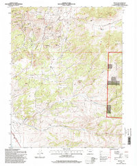
(14)- 1994 Map of Electric Peak, 1998 Print
 1994 Electric Peak1998 Print · USGSHigh in the Sangre de Cristo Mountains during the 1990s, this survey documents the high-altitude terrain along the Saguache and Custer county line. Trace historic mining sites like the Rita Alta Mine and Cloverdale Mine alongside the Rainbow Trail and Lakes of the Clouds.
 - 1994 Map of Hardscrabble Mountain, 1998 Print
 1994 Hardscrabble Mountain1998 Print · USGSIn the mid-1990s, these Custer County highlands remained a landscape of remote mountain peaks and deep forest drainages. Genealogists and historians can trace the vicinity of Ilse and the Silver Park Sch, or follow the course of Hardscrabble Creek.2 unique versions available
 - 1994 Map of Cotopaxi, 1998 Print
 1994 Cotopaxi1998 Print · USGSThe upper Arkansas River valley comes alive in the mid-1990s as it transitions from riverfront settlements to high mountain wilderness. Genealogists and researchers can trace the roads through Cotopaxi and Coaldale, or locate remote camps and trails like the Rainbow Trail and Rainbow Trail Camp.
 - 1994 Map of Curley Peak, 1998 Print
 1994 Curley Peak1998 Print · USGSThe Fremont and Custer County line in the mid-1990s is dominated by the high summits and gulches of the Isabel National Forest. Researchers can trace old mountain routes like the Oak Creek Grade and Tanner Trail as they pass by Yorkville and local prospects.
 - 1994 Map of Deer Peak, 1998 Print
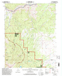
 1994 Deer Peak1998 Print · USGSCuster and Huerfano counties are shown here in the 1990s, dominated by the high-elevation peaks and canyons of the San Isabel National Forest. Researchers can trace old mining activities near Ophir Gulch or find the location of the Abbey Summer Camp and Lapin.
 - 1994 Map of Mount Tyndall, 1998 Print
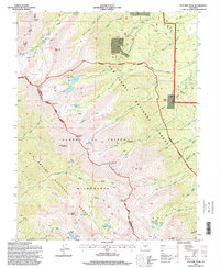
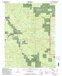
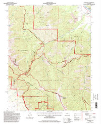
 1994 Mount Tyndall1998 Print · USGSCuster County ranching and silver-mining history are preserved here in the final years of the twentieth century. Genealogists and historians can trace old family holdings like Armstrong Ranch or find mining remnants near Querida and Bassick Hill.
 - 1994 Map of Saint Charles Peak, 1998 Print
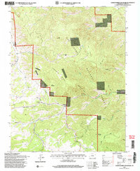
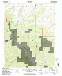
 1994 Saint Charles Peak1998 Print · USGSThe high country of the Wet Mountains comes into focus in the mid-1990s, where the San Isabel National Forest meets the Pueblo county line. Researchers can trace the Frontier Historic Trail and locate sites like Fairview, Silver Circle, and Saint Charles Peak.
 - 1994 Map of San Isabel, 1998 Print
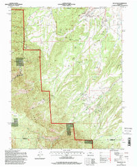
 1994 San Isabel1998 Print · USGSThe high Sangre de Cristo foothills and the San Isabel National Forest appear here in the mid-1990s. Researchers can trace the drainage of Greenhorn Creek, locate Rooster Spring, or find early recreational sites like Lazy Acres Camp and Lake Isabel.
 - 1994 Map of Coaldale, 1998 Print
 1994 Coaldale1998 Print · USGSThe high country of the Sangre de Cristo Range comes to life in the 1990s as it transitions from the Arkansas River valley into protected wilderness. Researchers can trace historic mining activity at the Strip Mine and Prospects or locate the Cem near Coaldale.
 - 1994 Map of Devils Gulch, 1998 Print
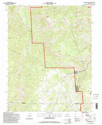
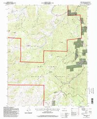
 1994 Devils Gulch1998 Print · USGSCuster and Huerfano counties meet along the high ridges of the Wet Mountain Valley in the mid-1990s. Researchers can trace historic ranching infrastructure and local landmarks like the Akin Ranch, the Bradford (Site), and several named windmills including Cordrey Windmill.
 - 1994 Map of Wetmore, 1998 Print
 1994 Wetmore1998 Print · USGSThe high country around Wetmore and Greenwood is captured in the mid-nineties as the area transitioned toward modern conservation. Genealogists and researchers can locate Don K Ranch and trace the many forks of Hardscrabble Creek.
 - 1994 Map of Rockvale, 1998 Print
 1994 Rockvale1998 Print · USGSFremont County's mining heart is on full display in the 1990s, where the rugged terrain meets the established communities of Rockvale and Coalcreek. Researchers can trace old operations like the Cedar Canon Mine, Caldrola No 1 Mine, and the historic Radiant Camp site.
 - 1994 Map of Rosita, 1998 Print
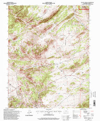
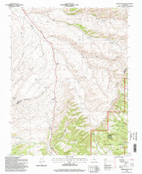
 1994 Rosita1998 Print · USGSCuster County's high-altitude mining and ranching legacy is preserved here in the final years of the twentieth century. Genealogists and historians can trace the foundations of Rosita and Querida, locate the Pioneer Cem, and find old mountain sites like Smith Ranch or Pocahontas Hill.
 - 1994 Map of Bear Creek, 1998 Print
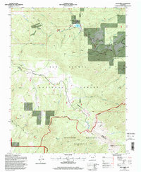
 1994 Bear Creek1998 Print · USGSThe high ridges of the Sangre de Cristo foothills come alive in this late twentieth-century survey of the Custer and Huerfano county line. Researchers can trace historic mineral exploration at various Prospects and follow the remote Horse Ranch Trail through Devils Hole.2 unique versions available
End of results
Showing maps 1-14 of 14
Top cities of Custer County
Frequently asked questions
- What are the different types of historical maps available for Custer County?
- What is the oldest map of Custer County?
- Where can I purchase historical maps of Custer County for my home or office?
- Where can I download high-res historical maps of Custer County?
- Are there historical topographic maps available for Custer County?
- Is there historical aerial imagery available for Custer County?
- Where are historical maps of Custer County sourced from?