2000-2009 Maps of Custer County, Colorado
Explore 6 historic maps of Custer County from 2000-2009. These maps offer a rare glimpse into what life looked like during the 2000s — showing old roads, neighborhoods, homes, and landmarks that have changed or disappeared over time.
Whether you're researching your family's past, planning a metal detecting trip, or studying how Custer County's landscape evolved across the 2000s, these high-resolution maps are a powerful tool for exploring the history of this region.
- Focus on a specific era: All maps on this page are from the 2000s, giving you a focused view of this time period.
- See what’s changed: Compare century-old streets, trails, and buildings to today's modern landscape using overlays and satellite layers.
- Research with precision: Use these maps for genealogy, historical research, land use analysis, or educational projects.
- View, download, or print: Maps are fully viewable online in high resolution, and can be downloaded or printed for your own records.
Start exploring Custer County's history through authentic maps from the 2000s. This is your window into the past.
Custer County, CO maps
(6)- 2001 Map of Crestone Peak, 2005 Print
 2001 Crestone Peak2005 Print · USGSHigh in the Sangre de Cristo range at the turn of the millennium, this survey details the peaks and wilderness bordering Saguache and Custer counties. Trace early mining Prospects near Luis Maria Baca Grant No 4 and high passes like Music Pass.
 - 2001 Map of Beckwith Mountain, 2005 Print
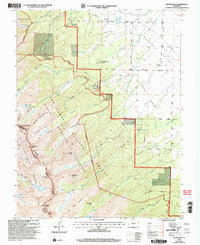
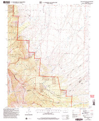
 2001 Beckwith Mountain2005 Print · USGSCuster County ranchlands meet the high peaks of the Sangre de Cristos in the early 2000s, showing a landscape defined by water rights and wilderness. Genealogists and local historians can locate The Pines Cem, Ula Cem, and old waterworks like the Reed Ditch.
 - 2001 Map of Valley View Hot Springs, 2005 Print
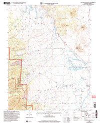
 2001 Valley View Hot Springs2005 Print · USGSThe Sangre de Cristo foothills near the Saguache and Custer county line are captured here as they appeared at the turn of the millennium. Local history researchers can locate the Orient Mine, trace trails into the wilderness, and find the Cotton Creek Cem.
 - 2001 Map of Horn Peak, 2005 Print
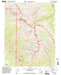
 2001 Horn Peak2005 Print · USGSThe Sangre de Cristo Mountains at the turn of the millennium are captured here in high detail. Hikers and historians can trace the paths of the Rainbow Trail and Venable Trail past landmarks like Horn Peak and Macey Lake.
 - 2001 Map of Rio Alto Peak, 2005 Print
 2001 Rio Alto Peak2005 Print · USGSThe high Sangre de Cristo range dominates this 2001 revision, showing the intricate boundary between Saguache and Custer counties. Hikers and historians can trace the Rito Alto Trail up to Hermit Pass or locate the Crestone Cem at the valley edge.
 - 2001 Map of Beck Mountain, 2005 Print
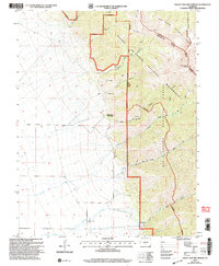
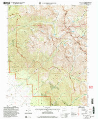
 2001 Beck Mountain2005 Print · USGSThe high Sangre de Cristo range meets the ranch lands of Custer County in this early 2000s survey. Hikers and historians can trace the Rainbow Trail, locate the Bear Creek Prospect, or find legacy family sites like Henrich Ranch and the Bradford area.
End of results
Showing maps 1-6 of 6
Top cities of Custer County
Frequently asked questions
- What are the different types of historical maps available for Custer County?
- What is the oldest map of Custer County?
- Where can I purchase historical maps of Custer County for my home or office?
- Where can I download high-res historical maps of Custer County?
- Are there historical topographic maps available for Custer County?
- Is there historical aerial imagery available for Custer County?
- Where are historical maps of Custer County sourced from?