Old Maps of El Paso County, Colorado for Genealogy
Trace your family roots with 388 historic maps of El Paso County. These high-res maps reveal old neighborhoods, homesites, landmarks, and streets — helping you uncover where your ancestors lived and how the area evolved over time.
- Explore historic neighborhoods: Identify where your relatives may have lived in the 1800s or 1900s.
- Compare maps over time: Trace the changes in streets, buildings, and landmarks for multi-generational research.
- Perfect for genealogy & ancestry research: Used by family historians and researchers to map out lineage and migration.
These maps are an incredible resource for exploring your personal connection to El Paso County's past.
El Paso County, CO maps
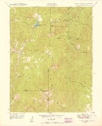
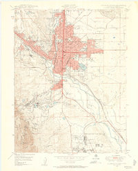
(388)- 1893 Map of Big Springs
 1893 Big Springs1893 Print · USGSEastern Colorado ranching country is documented here in the late nineteenth century, showing the early homesteads and water sources of the high plains. Researchers can locate the early holdings of Galloway Ranch and Hancock Ranch or trace the drainage of Black Squirrel Creek.5 unique versions available
 - 1893 Map of Platte Canyon
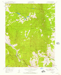
 1893 Platte Canyon1893 Print · USGSThe Front Range highlands come to life in the 1890s as the narrow-gauge Denver South Park and Pacific RR snakes through the mountains. Trace early mountain settlements like Pine Grove and Estabrook along the steep turns of South Platte Canyon.8 unique versions available
 - 1893 Map of Colorado Springs, 1896 Print
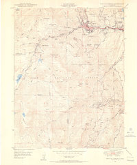
 1893 Colorado Springs1896 Print · USGSEl Paso County at the end of the nineteenth century was a booming intersection of mountain tourism and heavy rail commerce. Researchers can trace early railroad alignments like the Colorado Midland Railroad and locate vanished stops at Franceville Junction or Bierstadt.2 unique versions available
 - 1894 Map of Pikes Peak
 1894 Pikes Peak1894 Print · USGSThe Cripple Creek mining district is in its golden prime in the 1890s, caught here just as the mountain rail network was expanding. Researchers can trace early mining camps like Barry and Alnwick or locate the original path of the Colorado Midland Railroad through Florissant.2 unique versions available
 - 1894 Map of Castle Rock
 1894 Castle Rock1894 Print · USGSThe Front Range high country in the 1890s reveals a landscape of ranching hubs and competing rail lines. Trace early transit routes like the Denver and Rio Grande Railroad through Castle Rock, Larkspur, and Monument.2 unique versions available
 - 1901 Map of Pikes Peak
 1901 Pikes Peak1901 Print · USGSThe Cripple Creek mining district is in its golden age on this turn-of-the-century sheet. Genealogists and historians can trace the rail lines and mountain camps that defined the rush, from Victor and Goldfield to the Fossil Beds at Florissant.6 unique versions available
 - 1901 Map of Pikes Peak, 1909 Print
 1901 Pikes Peak1909 Print · USGSThe mining district of Teller County is shown at its height, as rail lines threaded through high-altitude gold camps. Genealogists can trace family roots in Cripple Creek, Independence, and Altman or locate the historic Fossil Beds near Florissant.
 - 1909 Map of Colorado Springs
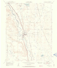
 1909 Colorado Springs1909 Print · USGSColorado Springs and the Front Range foothills are shown here at a pivotal era of rail expansion and early tourism. Genealogists and historians can trace defunct rail lines, rural schoolhouse locations like Grandview School, and landmarks such as the Cliff Dwellings and Burial Rocks.5 unique versions available
 - 1913 Map of Castle Rock
 1913 Castle Rock1913 Print · USGSThe Colorado front range at the start of the twentieth century was a landscape of high-plains ranching and vital rail junctions. Genealogists can locate family homesteads near dozens of early schools like Rock Ridge School and churches such as Bethel Church.5 unique versions available
 - 1940 Map of Elbert, 1956 Print
 1940 Elbert1956 Print · USGSThe high plains of Elbert and El Paso counties are captured here in the years leading up to the mid-century, where the edge of the Black Forest meets a network of family ranches. Researchers can trace dozens of country landmarks, from the Chicago Rock Island & Pacific railroad to schoolhouses like James Sch and Sidney Sch.2 unique versions available
 - 1942 Map of Colorado Springs
 1942 Colorado Springs1942 Print · USGSColorado Springs and the Front Range appear here in the early years of the Second World War. Genealogists and historians can trace the rail corridors of the Chicago Rock Island and Pacific RR and locate sites like the Printers Home and Glen Eyrie.
 - 1944 Map of Elbert
 1944 Elbert1944 Print · USGSRanching and rural education define this Elbert County landscape in the mid-1940s. Genealogists can trace family landmarks like the Ten-Sleep Ranch or locate vanished school sites like James Sch and Sidney Sch.2 unique versions available
 - 1948 Map of Falcon, 1952 Print
 1948 Falcon1952 Print · USGSEl Paso County ranching culture is at its peak in the late 1940s, showing a landscape defined by cattle operations and the railway. Genealogists and historians can locate specific family homesteads like Old Orr Ranch and Blaney Ranch or trace the Chicago Rock Island and Pacific and Southern Colorado Railroad through Falcon.2 unique versions available
 - 1948 Map of Mount Big Chief, 1953 Print
 1948 Mount Big Chief1953 Print · USGSThe Front Range high country comes alive in this post-war survey of the mountains southwest of Colorado Springs. Researchers can trace historic mountain retreats and outposts like Broadmoor Lodge, Rosemont, and the Emerald Valley Boys Camp.2 unique versions available
 - 1948 Map of Mount Pittsburg, 1956 Print
 1948 Mount Pittsburg1956 Print · USGSSouthern Colorado ranching country is captured here just after the war, showing the foothills at the convergence of three counties. Local historians can locate early family-named sites like Fords Mountaindale Ranch and the Red Creek School.
 - 1948 Map of Timber Mountain, 1956 Print
 1948 Timber Mountain1956 Print · USGSThe foothills of the Front Range come alive in the late 1940s, showing a landscape shared by massive military installations and traditional ranching. Genealogists can locate specific family sites like Earley Ranch and Avery Ranch or the historic Lytle Sch.
 - 1948 Map of Manitou Springs, 1956 Print
 1948 Manitou Springs1956 Print · USGSManitou Springs and the surrounding mountain canyons are captured here just after the war, revealing a landscape defined by tourism and rail engineering. Trace the route of the Manitou and Pikes Peak Cog RR, locate the Halen Hunt Jackson Cemetery, or find old outposts like Minnehaha and Artists Glen.2 unique versions available
 - 1948 Map of Fountain SE, 1957 Print
 1948 Fountain SE1957 Print · USGSEl Paso and Pueblo counties are captured here in the late 1940s, highlighting a quiet landscape of high-plains ranching and essential rail transport. Genealogists and historians can trace local family landholdings like Hammer Ranch, Paige Ranch, and the Kaufman Place.
 - 1948 Map of Colorado Springs, 1957 Print
 1948 Colorado Springs1957 Print · USGSColorado Springs and the Front Range foothills are captured here in the late Forties, just as post-war growth began to accelerate. Genealogists and historians can trace institutional landmarks like the Modern Woodmen of America Sanatorium and the Myron Stratton Home alongside the early bounds of Camp Carson.
 - 1948 Map of Pikeview, 1957 Print
 1948 Pikeview1957 Print · USGSEl Paso County at the end of the 1940s shows a landscape of sanitariums, ranches, and dual rail lines. Genealogists can trace family footprints at Reverse J Diamond Ranch, the Woodmen School, and the settlement of Papeton.
 - 1948 Map of Cascade, 1958 Print
 1948 Cascade1958 Print · USGSEl Paso County mountain communities and the eastern foothills of the Rampart Range are captured here in the late 1940s. Genealogists and historians can trace the foundations of Cascade, Chipita Park, and Woodmen, or locate the historic Toll Gate along Ute Pass.2 unique versions available
 - 1948 Map of Fountain, 1958 Print
 1948 Fountain1958 Print · USGSThe high plains of El Paso County are captured here just after the war, showing the expansion of military lands and rail lines. You can trace the railroad corridors through Fountain and locate local landmarks like Fairview Cemetery and Widefield School.
 - 1948 Map of Colorado Springs, 1958 Print
 1948 Colorado Springs1958 Print · USGSColorado Springs is shown here in the late 1940s, as its urban footprint expanded toward the foothills. Researchers can trace historic landmarks like the Union Printers Home, the Will Rogers Shrine of the Sun, and the grounds of Colorado College.2 unique versions available
 - 1948 Map of Cheyenne Mountain, 1959 Print
 1948 Cheyenne Mountain1959 Print · USGSEl Paso County at the end of the 1940s shows the post-war growth of Camp Carson alongside traditional ranching and academic retreats. You can trace the Military Reservation Boundary and locate the Iowa State College Camp or Hitch Rack Ranch.
 - 1948 Map of Falcon, 1960 Print
 1948 Falcon1960 Print · USGSEl Paso County ranching and early aviation come to life in the late 1940s as the high plains expand east of the mountains. Genealogists and researchers can locate family-named landmarks like Banning Lewis Ranch, trace the rail corridor of the Chicago Rock Island and Pacific, and see the early layout of Peterson Field.
Showing maps 1-25 of 388
Top cities of El Paso County
- Colorado Springs historical maps
- Fountain historical maps
- Manitou Springs historical maps
- Monument historical maps
- Palmer Lake historical maps
- Calhan historical maps
See more
Frequently asked questions
- What are the different types of historical maps available for El Paso County?
- What is the oldest map of El Paso County?
- Where can I purchase historical maps of El Paso County for my home or office?
- Where can I download high-res historical maps of El Paso County?
- Are there historical topographic maps available for El Paso County?
- Is there historical aerial imagery available for El Paso County?
- Where are historical maps of El Paso County sourced from?