1950s Maps of Hinsdale County, Colorado
Explore 8 historic maps of Hinsdale County from the 1950s. These maps offer a rare glimpse into what life looked like during the 1950s — showing old roads, neighborhoods, homes, and landmarks that have changed or disappeared over time.
Whether you're researching your family's past, planning a metal detecting trip, or studying how Hinsdale County's landscape evolved across the 1950s, these high-resolution maps are a powerful tool for exploring the history of this region.
- Focus on a specific era: All maps on this page are from the 1950s, giving you a focused view of this time period.
- See what’s changed: Compare century-old streets, trails, and buildings to today's modern landscape using overlays and satellite layers.
- Research with precision: Use these maps for genealogy, historical research, land use analysis, or educational projects.
- View, download, or print: Maps are fully viewable online in high resolution, and can be downloaded or printed for your own records.
Start exploring Hinsdale County's history through authentic maps from the 1950s. This is your window into the past.
Hinsdale County, CO maps
(8)- 1953 Map of Durango, 1963 Print
 1953 Durango1963 Print · USGSThe high peaks of the San Juan Mountains and the Colorado mining country are shown here as they appeared in the early fifties. Genealogists and local historians can trace the rail lines of the D & R G W RR and locate historic mining camps like Silverton, Ouray, and Old Ophir.
 - 1954 Map of Durango
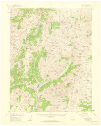
 1954 Durango1954 Print · USGSSouthern Colorado in the mid-1950s was defined by high-altitude mining towns and the expansion of water storage in the San Luis Valley. Trace the narrow-gauge Denver & Rio Grande Western RR as it connects Durango to mountain outposts like Silverton and Creede.2 unique versions available
 - 1955 Map of Handies Peak, 1957 Print
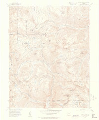 1955 Handies Peak1957 Print · USGSHigh-altitude mining camps and mountain passes characterize the San Juan Mountains during the mid-fifties. Genealogists and historians can trace the foundations of Animas Forks, the Sunnyside Mine, and the Old Lout Mine.7 unique versions available
 - 1955 Map of Howardsville, 1957 Print
 1955 Howardsville1957 Print · USGSThe San Juan high country in the mid-1950s reveals a landscape still thick with the infrastructure of the mining boom. Researchers can trace the path of numerous aerial tramways connecting the Animas River valley to storied sites like the Old Hundred Mine and Silver Lake Mine.8 unique versions available
 - 1955 Map of Silverton, 1960 Print
 1955 Silverton1960 Print · USGSSilverton and the high San Juans are shown at a peak of mid-century mining activity, linked by rail and the mountain-hugging Million Dollar Highway. Researchers can trace historic claims and infrastructure from the Mayflower Mill to the remote Eureka and Howardsville town sites.3 unique versions available
 - 1956 Map of Montrose, 1963 Print
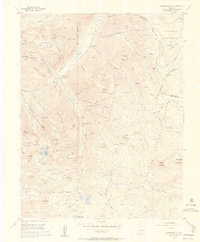
 1956 Montrose1963 Print · USGSThe Colorado western slope in the late fifties and early sixties shows a landscape defined by the Denver & Rio Grande Western RR and the Gunnison River. Trace the development of Blue Mesa Reservoir or locate high-country sites like the Bachelor Mine.3 unique versions available
 - 1959 Map of Montrose
 1959 Montrose1959 Print · USGSWestern Colorado in the late fifties is defined by the high peaks and river valleys of the Southern Rockies. Genealogists and historians can trace the paths of the Denver & Rio Grande Western RR or locate mountain settlements like Crawford, Lazear, and Doyleville.
 - 1959 Map of Bristol Head, 1961 Print
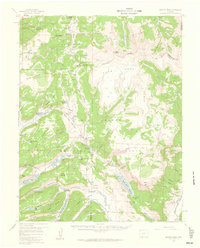 1959 Bristol Head1961 Print · USGSHinsdale and Mineral Counties are shown here during the late fifties, dominated by high-altitude ranching and the remnants of pioneer stage lines. Researchers can trace old mountain routes like the Slumgullion Pass and locate historic sites such as Rambouillet and the Powderhorn Old Stage Sta (Ruins).7 unique versions available
End of results
Showing maps 1-8 of 8
Top cities of Hinsdale County
Frequently asked questions
- What are the different types of historical maps available for Hinsdale County?
- What is the oldest map of Hinsdale County?
- Where can I purchase historical maps of Hinsdale County for my home or office?
- Where can I download high-res historical maps of Hinsdale County?
- Are there historical topographic maps available for Hinsdale County?
- Is there historical aerial imagery available for Hinsdale County?
- Where are historical maps of Hinsdale County sourced from?