1970s Maps of Hinsdale County, Colorado
Explore 4 historic maps of Hinsdale County from the 1970s. These maps offer a rare glimpse into what life looked like during the 1970s — showing old roads, neighborhoods, homes, and landmarks that have changed or disappeared over time.
Whether you're researching your family's past, planning a metal detecting trip, or studying how Hinsdale County's landscape evolved across the 1970s, these high-resolution maps are a powerful tool for exploring the history of this region.
- Focus on a specific era: All maps on this page are from the 1970s, giving you a focused view of this time period.
- See what’s changed: Compare century-old streets, trails, and buildings to today's modern landscape using overlays and satellite layers.
- Research with precision: Use these maps for genealogy, historical research, land use analysis, or educational projects.
- View, download, or print: Maps are fully viewable online in high resolution, and can be downloaded or printed for your own records.
Start exploring Hinsdale County's history through authentic maps from the 1970s. This is your window into the past.
Hinsdale County, CO maps
(4)- 1973 Map of Granite Lake, 1975 Print
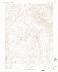 1973 Granite Lake1975 Print · USGSHinsdale County’s high wilderness is captured in the early 1970s, showing a landscape defined by the Continental Divide and remote alpine basins. Researchers can trace the network of Pack Trails connecting landmarks like the Granite Peak Guard Sta, Elk Park, and Granite Lake.2 unique versions available
 - 1973 Map of Cimarrona Peak, 1975 Print
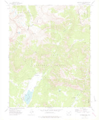 1973 Cimarrona Peak1975 Print · USGSHinsdale and Mineral counties meet along the high ridges of the San Juan Mountains in the early seventies. Backcountry researchers can trace wilderness routes near Cimarrona Peak or locate established camps like Teal Campground and Middle Fork Hunter Campground.4 unique versions available
 - 1973 Map of Emerald Lake, 1976 Print
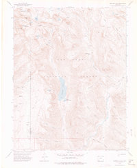 1973 Emerald Lake1976 Print · USGSThe high wilderness of Hinsdale and La Plata counties is captured here in the early 1970s, focused on the San Juan National Forest. Researchers and hikers can trace primitive routes like the Flint Creek Trail to alpine landmarks including Emerald Lake, Mount Oso, and Barebottom Park.4 unique versions available
 - 1973 Map of Palomino Mountain, 1976 Print
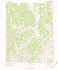 1973 Palomino Mountain1976 Print · USGSThe Mineral County high country is captured here in the early 1970s, showcasing the remote wilderness at the meeting of two national forests. Trace the Continental Divide and historic Pack Trails past Piedra Pass and Window Lake.4 unique versions available
End of results
Showing maps 1-4 of 4
Top cities of Hinsdale County
Frequently asked questions
- What are the different types of historical maps available for Hinsdale County?
- What is the oldest map of Hinsdale County?
- Where can I purchase historical maps of Hinsdale County for my home or office?
- Where can I download high-res historical maps of Hinsdale County?
- Are there historical topographic maps available for Hinsdale County?
- Is there historical aerial imagery available for Hinsdale County?
- Where are historical maps of Hinsdale County sourced from?