1910s Maps of La Plata County, Colorado
Explore 3 historic maps of La Plata County from the 1910s. These maps offer a rare glimpse into what life looked like during the 1910s — showing old roads, neighborhoods, homes, and landmarks that have changed or disappeared over time.
Whether you're researching your family's past, planning a metal detecting trip, or studying how La Plata County's landscape evolved across the 1910s, these high-resolution maps are a powerful tool for exploring the history of this region.
- Focus on a specific era: All maps on this page are from the 1910s, giving you a focused view of this time period.
- See what’s changed: Compare century-old streets, trails, and buildings to today's modern landscape using overlays and satellite layers.
- Research with precision: Use these maps for genealogy, historical research, land use analysis, or educational projects.
- View, download, or print: Maps are fully viewable online in high resolution, and can be downloaded or printed for your own records.
Start exploring La Plata County's history through authentic maps from the 1910s. This is your window into the past.
La Plata County, CO maps
(3)- 1912 Map of Soda Canyon
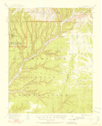 1912 Soda Canyon1912 Print · USGSMontezuma County at the dawn of modern archaeology reveals a landscape dotted with ancestral dwellings. Researchers can trace the early documentation of Cliff Palace, Sprucetree House, and Balcony House alongside the winding course of the Mancos River.7 unique versions available
 - 1913 Map of Red Mesa
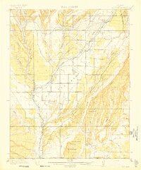 1913 Red Mesa1913 Print · USGSLa Plata County's high mesa country is captured here shortly after the turn of the century, showing a landscape of early homesteads and irrigation ditches. Researchers can locate the Mormon Church, several early schools like Rockville School, and the tracks of the Rio Grande Southern RR.4 unique versions available
 - 1915 Map of Soda Canyon
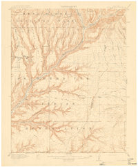 1915 Soda Canyon1915 Print · USGSSouthwestern Colorado at the onset of the Great War reveals a landscape defined by deep canyons and ancient ruins. Archaeologists and historians can trace the early locations of Cliff Palace, the Double Walled Tower, and Waters Ranch.7 unique versions available
End of results
Showing maps 1-3 of 3
Top cities of La Plata County
Frequently asked questions
- What are the different types of historical maps available for La Plata County?
- What is the oldest map of La Plata County?
- Where can I purchase historical maps of La Plata County for my home or office?
- Where can I download high-res historical maps of La Plata County?
- Are there historical topographic maps available for La Plata County?
- Is there historical aerial imagery available for La Plata County?
- Where are historical maps of La Plata County sourced from?