1950s Maps of La Plata County, Colorado
Explore 9 historic maps of La Plata County from the 1950s. These maps offer a rare glimpse into what life looked like during the 1950s — showing old roads, neighborhoods, homes, and landmarks that have changed or disappeared over time.
Whether you're researching your family's past, planning a metal detecting trip, or studying how La Plata County's landscape evolved across the 1950s, these high-resolution maps are a powerful tool for exploring the history of this region.
- Focus on a specific era: All maps on this page are from the 1950s, giving you a focused view of this time period.
- See what’s changed: Compare century-old streets, trails, and buildings to today's modern landscape using overlays and satellite layers.
- Research with precision: Use these maps for genealogy, historical research, land use analysis, or educational projects.
- View, download, or print: Maps are fully viewable online in high resolution, and can be downloaded or printed for your own records.
Start exploring La Plata County's history through authentic maps from the 1950s. This is your window into the past.
La Plata County, CO maps
(9)- 1953 Map of Durango, 1963 Print
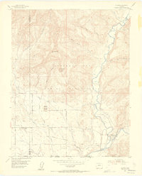
 1953 Durango1963 Print · USGSThe high peaks of the San Juan Mountains and the Colorado mining country are shown here as they appeared in the early fifties. Genealogists and local historians can trace the rail lines of the D & R G W RR and locate historic mining camps like Silverton, Ouray, and Old Ophir.
 - 1954 Map of Durango
 1954 Durango1954 Print · USGSSouthern Colorado in the mid-1950s was defined by high-altitude mining towns and the expansion of water storage in the San Luis Valley. Trace the narrow-gauge Denver & Rio Grande Western RR as it connects Durango to mountain outposts like Silverton and Creede.2 unique versions available
 - 1954 Map of Shiprock
 1954 Shiprock1954 Print · USGSThe Four Corners region in the mid-fifties reveals a vast landscape of tribal lands and desert landmarks. Researchers can trace the mid-century footprints of the Navajo Indian Reservation, identifying remote Trading Posts, the early growth of Farmington, and the iconic spire of Ship Rock.5 unique versions available
 - 1954 Map of Allison, 1955 Print
 1954 Allison1955 Print · USGSSettlements along the New Mexico border were defined by the railroad and river in the mid-1950s. You can trace the historic Denver and Rio Grande Western line through Allison and Arboles or locate the Cem and irrigation works like the Pine River Canal.7 unique versions available
 - 1956 Map of Cortez, 1972 Print
 1956 Cortez1972 Print · USGSThe Four Corners region comes alive in this mid-century study of the high plateaus and deep canyons surrounding Cortez. Trace the development of desert outposts like Towaoc or follow the historic Laramie Trail across a landscape dotted with ancient sites at Mesa Verde National Park.2 unique versions available
 - 1958 Map of Cortez
 1958 Cortez1958 Print · USGSThe Four Corners region comes alive in the late fifties, showing the interplay between expanding mountain settlements and ancient archeological sites. Trace the layout of Cortez, Monticello, and Blanding alongside landmarks like Mesa Verde National Park and Fort Lewis A&M College.
 - 1958 Map of Shiprock
 1958 Shiprock1958 Print · USGSThe Four Corners region in the mid-fifties shows a vast network of remote outposts and river settlements. You can locate numerous historic sites like the Emmanuel Mission and several commercial hubs such as Burnham Trading Post and Bisti Trading Post.
 - 1959 Map of Shiprock
 1959 Shiprock1959 Print · USGSThe Four Corners region comes alive in the mid-fifties, showing the high desert outposts and river-valley towns of the Navajo Nation and San Juan County. Genealogists and researchers can locate remote landmarks like the Burnham Trading Post, Two Grey Hills, and the early Helium Plant.
 - 1959 Map of Cortez
 1959 Cortez1959 Print · USGSThe Four Corners region in the late fifties was a landscape of ancestral sites and isolated ranching outposts. Genealogists and historians can trace the early footprints of Cortez, Towaoc, and Mexican Hat alongside the canyons of the San Juan River.2 unique versions available
End of results
Showing maps 1-9 of 9
Top cities of La Plata County
Frequently asked questions
- What are the different types of historical maps available for La Plata County?
- What is the oldest map of La Plata County?
- Where can I purchase historical maps of La Plata County for my home or office?
- Where can I download high-res historical maps of La Plata County?
- Are there historical topographic maps available for La Plata County?
- Is there historical aerial imagery available for La Plata County?
- Where are historical maps of La Plata County sourced from?