1980s Maps of La Plata County, Colorado
Explore 5 historic maps of La Plata County from the 1980s. These maps offer a rare glimpse into what life looked like during the 1980s — showing old roads, neighborhoods, homes, and landmarks that have changed or disappeared over time.
Whether you're researching your family's past, planning a metal detecting trip, or studying how La Plata County's landscape evolved across the 1980s, these high-resolution maps are a powerful tool for exploring the history of this region.
- Focus on a specific era: All maps on this page are from the 1980s, giving you a focused view of this time period.
- See what’s changed: Compare century-old streets, trails, and buildings to today's modern landscape using overlays and satellite layers.
- Research with precision: Use these maps for genealogy, historical research, land use analysis, or educational projects.
- View, download, or print: Maps are fully viewable online in high resolution, and can be downloaded or printed for your own records.
Start exploring La Plata County's history through authentic maps from the 1980s. This is your window into the past.
La Plata County, CO maps
(5)- 1980 Map of Farmington, 1981 Print
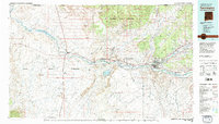 1980 Farmington1981 Print · USGSIn the San Juan Basin during the early 1980s, the energy economy was rapidly transforming the landscape around Farmington and Shiprock. Genealogists and historians can trace the growth of river towns like Kirtland or locate specific sites like the Navajo Mine and Aztec Ruins.2 unique versions available
 - 1982 Map of Dove Creek
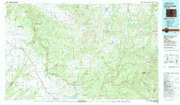 1982 Dove Creek1982 Print · USGSThe high plateaus and deep canyons of Southwest Colorado are captured in the early 1980s as the McPhee Dam takes shape. Genealogists and researchers can locate remote settlements like Egnar and Cahone or trace family mining claims at the Effie B Mine.
 - 1982 Map of Silverton, 1983 Print
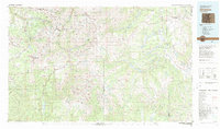 1982 Silverton1983 Print · USGSThe San Juan Mountains were entering a new era in the early eighties as mining heritage met growing wilderness preservation. Researchers can trace historic claims and mountain rail routes through Silverton, Telluride, and the high-altitude Sunnyside Mine.3 unique versions available
 - 1982 Map of Cortez, 1992 Print
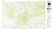 1982 Cortez1992 Print · USGSMontezuma County at the start of the eighties shows a landscape defined by federal and tribal lands, from the archaeological sites of Mesa Verde National Park to the Ute Mountain Indian Reservation. Trace local history through small settlements like Lebanon and Marvel or follow the path of an Old Railroad Grade.
 - 1983 Map of Durango
 1983 Durango1983 Print · USGSSouthwestern Colorado at the start of the 1980s shows a landscape where high-mountain wilderness meets the agricultural plateaus of the Southern Ute. Genealogists and historians can trace the Durango & Silverton Narrow Gauge Railroad or locate sites like Southern Ute Agency and Pagosa Junction.
End of results
Showing maps 1-5 of 5
Top cities of La Plata County
Frequently asked questions
- What are the different types of historical maps available for La Plata County?
- What is the oldest map of La Plata County?
- Where can I purchase historical maps of La Plata County for my home or office?
- Where can I download high-res historical maps of La Plata County?
- Are there historical topographic maps available for La Plata County?
- Is there historical aerial imagery available for La Plata County?
- Where are historical maps of La Plata County sourced from?