1950s Maps of Las Animas County, Colorado
Explore 14 historic maps of Las Animas County from the 1950s. These maps offer a rare glimpse into what life looked like during the 1950s — showing old roads, neighborhoods, homes, and landmarks that have changed or disappeared over time.
Whether you're researching your family's past, planning a metal detecting trip, or studying how Las Animas County's landscape evolved across the 1950s, these high-resolution maps are a powerful tool for exploring the history of this region.
- Focus on a specific era: All maps on this page are from the 1950s, giving you a focused view of this time period.
- See what’s changed: Compare century-old streets, trails, and buildings to today's modern landscape using overlays and satellite layers.
- Research with precision: Use these maps for genealogy, historical research, land use analysis, or educational projects.
- View, download, or print: Maps are fully viewable online in high resolution, and can be downloaded or printed for your own records.
Start exploring Las Animas County's history through authentic maps from the 1950s. This is your window into the past.
Las Animas County, CO maps
(14)- 1951 Map of Trinidad, 1953 Print
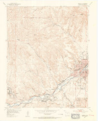 1951 Trinidad1953 Print · USGSTrinidad and the Purgatoire River valley are shown here in the early fifties during a period of industrial transition. Researchers can trace the extensive coal mining infrastructure at Starkville and Cokedale or locate family roots at the Masonic Cemetery and St Josephs Church.6 unique versions available
 - 1951 Map of Valdez, 1953 Print
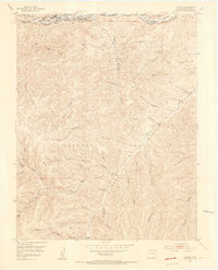 1951 Valdez1953 Print · USGSLas Animas County was a hub of coal production and rail activity during the mid-century transition. Researchers can trace the industrial footprint of the Frederick Mine, locate the Tijeras Cemetery, and explore the canyon-laced geography of the Maxwell Grant.5 unique versions available
 - 1951 Map of Madrid, 1953 Print
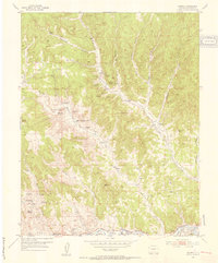 1951 Madrid1953 Print · USGSLas Animas County at the dawn of the 1950s shows a landscape of coal mining settlements and canyon-floor ranching. Genealogists can trace the history of mining families near Boncarbo and Primero, locating landmarks like San Juan Cemetery and several abandoned schools.3 unique versions available
 - 1951 Map of Starkville, 1953 Print
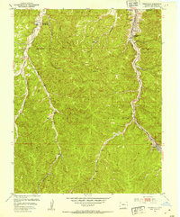 1951 Starkville1953 Print · USGSSouthern Colorado coal country comes to life in the early fifties as industrial operations and local life center on the canyons of the Maxwell Grant. Genealogists can trace the Starkville community through its three local schools and the Starkville Cemetery.5 unique versions available
 - 1954 Map of Raton, 1963 Print
 1954 Raton1963 Print · USGSNorthern New Mexico's high-country and plains are documented here in the early sixties, showing the region's ranching and mining infrastructure. Trace the legacy of the Maxwell Land Grant, locate remote rural sites like Tafoya School, and follow the Atchison Topeka and Santa Fe Railway through the heart of Raton.3 unique versions available
 - 1954 Map of Trinidad, 1963 Print
 1954 Trinidad1963 Print · USGSSouthern Colorado is captured here during the mid-fifties, showing the vital rail-and-river connections between the San Luis Valley and the eastern foothills. Researchers can trace the Denver and Rio Grande Western line and locate rural landmarks like Malachite School and San Luis.2 unique versions available
 - 1954 Map of Dalhart, 1967 Print
 1954 Dalhart1967 Print · USGSThe High Plains at the junction of four states come alive in the mid-fifties, showing a landscape of rail-hub towns and cattle country. Trace the Old Santa Fe Trail or locate mid-century industrial sites like the Dry ice plant and Carbon Dioxide Works.2 unique versions available
 - 1955 Map of La Junta, 1966 Print
 1955 La Junta1966 Print · USGSSoutheastern Colorado during the mid-fifties is captured here as a sprawling network of ranching outposts and rail sidings. Researchers can locate vanished landmarks like the Sunderland School, trace the isolated Lycan Post Office, or find the Bomb target (abandoned) on the western plains.3 unique versions available
 - 1955 Map of Trinidad, 1976 Print
 1955 Trinidad1976 Print · USGSSouthern Colorado during the mid-fifties is defined by the high-altitude agriculture of the San Luis Valley and the peaks of the Culebra Range. Genealogists can trace early settlements and rural schoolhouses like Medina Plaza, San Luis, and the Trujillo Creek School.
 - 1958 Map of Raton
 1958 Raton1958 Print · USGSNorthern New Mexico and the Colorado borderlands are mapped here in the late fifties, showcasing a landscape of high peaks and historic land grants. Genealogists and historians can trace families across Picuris Pueblo, find old schoolhouses like Piedra Lumbre School, or follow the Atchison Topeka and Santa Fe rail line.3 unique versions available
 - 1958 Map of La Junta
 1958 La Junta1958 Print · USGSSoutheast Colorado and the Kansas borderlands appear in the late fifties as a landscape of isolated ranching outposts and vital rail junctions. Researchers can trace the lineage of vanished post offices and rural school sites like the Lycan Post Office and Sunderland School.2 unique versions available
 - 1958 Map of Trinidad
 1958 Trinidad1958 Print · USGSSouthern Colorado in the late fifties was a landscape of high-altitude agriculture and coal production, centered on the San Luis Valley. Local historians can trace old community centers like the Malachite School or follow the mining and rail activity near Walsenburg and the Allen Mine.
 - 1958 Map of Dalhart
 1958 Dalhart1958 Print · USGSThe High Plains of the tri-state border region come alive in this mid-century survey of the ranching and rail territory around the Texas Panhandle. Genealogists and historians can trace the paths of the Atchison Topeka & Santa Fe Ry, military outposts like Dalhart Air Force No 1, and early settlements such as Pasamonte and Texline.2 unique versions available
 - 1959 Map of Trinidad
 1959 Trinidad1959 Print · USGSThe San Luis Valley and the high Sangre de Cristo peaks are documented here in the late fifties, during a period of steady ranching and rail activity. Genealogy researchers can locate family-named landmarks and rural institutions like Trujillo Creek School and the historic San Luis settlement.
End of results
Showing maps 1-14 of 14
Top cities of Las Animas County
- Trinidad historical maps
- Aguilar historical maps
- Cokedale historical maps
- Kim historical maps
- Branson historical maps
- Starkville historical maps
Frequently asked questions
- What are the different types of historical maps available for Las Animas County?
- What is the oldest map of Las Animas County?
- Where can I purchase historical maps of Las Animas County for my home or office?
- Where can I download high-res historical maps of Las Animas County?
- Are there historical topographic maps available for Las Animas County?
- Is there historical aerial imagery available for Las Animas County?
- Where are historical maps of Las Animas County sourced from?