2000-2009 Maps of Mineral County, Colorado
Explore 19 historic maps of Mineral County from 2000-2009. These maps offer a rare glimpse into what life looked like during the 2000s — showing old roads, neighborhoods, homes, and landmarks that have changed or disappeared over time.
Whether you're researching your family's past, planning a metal detecting trip, or studying how Mineral County's landscape evolved across the 2000s, these high-resolution maps are a powerful tool for exploring the history of this region.
- Focus on a specific era: All maps on this page are from the 2000s, giving you a focused view of this time period.
- See what’s changed: Compare century-old streets, trails, and buildings to today's modern landscape using overlays and satellite layers.
- Research with precision: Use these maps for genealogy, historical research, land use analysis, or educational projects.
- View, download, or print: Maps are fully viewable online in high resolution, and can be downloaded or printed for your own records.
Start exploring Mineral County's history through authentic maps from the 2000s. This is your window into the past.
Mineral County, CO maps
(19)- 2001 Map of Palomino Mountain
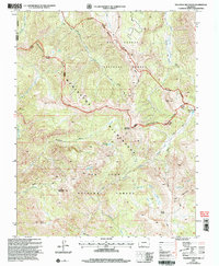 2001 Palomino Mountain2001 Print · USGSThe high alpine crest of the Continental Divide dominates this turn-of-the-millennium survey of the Colorado backcountry. Researchers can trace the headwaters of the Blanco River or locate remote landmarks like Palomino Mountain and Monument Lake.
 - 2001 Map of Elwood Pass, 2005 Print
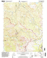 2001 Elwood Pass2005 Print · USGSHigh in the San Juan Mountains at the turn of the twenty-first century, this landscape preserves the rugged intersection of the Continental Divide. Researchers can trace historic alpine routes and prospecting sites like Elwood Pass, Black Diamond Mine, and McCormick Cabin.2 unique versions available
 - 2001 Map of Halfmoon Pass, 2005 Print
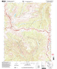
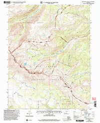 2001 Halfmoon Pass2005 Print · USGSSaguache and Mineral counties at the start of the millennium showcase the high-country divide of the Colorado Rockies. You can trace the La Garita Stock Driveway and the primitive routes leading to Halfmoon Pass and the Wheeler Geologic Area.
 - 2001 Map of Bristol Head, 2005 Print
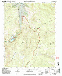
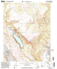 2001 Bristol Head2005 Print · USGSMineral County's high-country terrain is captured here at the turn of the millennium, showing the critical water management and forest boundaries of the era. Researchers can trace historic access routes like the Willow Creek Trail or locate alpine landmarks such as Ghost Lake and Santa Maria Pass.
 - 2001 Map of San Luis Peak, 2005 Print
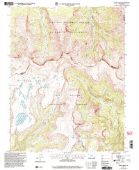
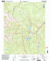
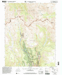 2001 San Luis Peak2005 Print · USGSMineral County mining history and wilderness preservation meet at the Continental Divide during the turn of the millennium. Researchers can trace the legacy of silver and gold through former settlements like Bachelor and Weaver or find the Amethyst and Equity Mine operations.
 - 2001 Map of Lake Humphreys, 2005 Print
 2001 Lake Humphreys2005 Print · USGSMineral County at the turn of the millennium is shown here as a high-country wilderness defined by peaks and hidden lakes. Trace the routes of the Highline Trail and Pierce Trail to find historical sites like the Mine and Lake Humphreys.
 - 2001 Map of Mesa Mountain, 2005 Print
 2001 Mesa Mountain2005 Print · USGSSaguache County at the turn of the twenty-first century remains a landscape of high-altitude mining and traditional ranching access. Researchers can trace historic pathways like the Saguache Divide Stock Driveway or locate the remote Sky City Mine.
 - 2001 Map of Workman Creek, 2005 Print
 2001 Workman Creek2005 Print · USGSThe Mineral County high country at the start of the millennium remains a pristine landscape of wilderness and water. Researchers can trace the historic Stock Driveway, locate the Sulphur Tunnel, and follow the Rio Grande as it cuts past Antelope Mountain.
 - 2001 Map of Beaver Creek Reservoir, 2005 Print
 2001 Beaver Creek Reservoir2005 Print · USGSHigh in the Rio Grande National Forest during the early 2000s, this area serves as a vital watershed defined by mountain peaks and alpine reservoirs. Researchers can trace the routes of the Tewksberry Trail and identify local landmarks like the Beaver Creek Youth Camp and Poage Lake.
 - 2001 Map of Spar City, 2005 Print
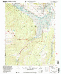
 2001 Spar City2005 Print · USGSThe high country of Mineral County was still a landscape of active discovery and mountain wilderness at the turn of the millennium. Mineral prospectors and hikers can trace the legacy of Spar City and find old workings like the Denver Tunnel and Emme Mine.
 - 2001 Map of Wagon Wheel Gap, 2005 Print
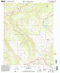
 2001 Wagon Wheel Gap2005 Print · USGSMineral County high country at the turn of the millennium shows a landscape defined by the Rio Grande and its rugged alpine tributaries. Researchers can locate remote markers of local history like the Grave near Mc Kinney Gulch or trace old mining Prospect sites near Ute Peak.
 - 2001 Map of South Fork West, 2005 Print
 2001 South Fork West2005 Print · USGSThe confluence of the Rio Grande and its southern fork comes into sharp focus during the late twentieth century. Genealogists and local historians can trace the development of seasonal retreats like Alamo Summer Homes and Masonic Park alongside the vital Highline Ditch.
 - 2001 Map of South River Peak, 2005 Print
 2001 South River Peak2005 Print · USGSMineral County's high-altitude wilderness at the start of the millennium is defined by the winding Continental Divide. Backcountry researchers can trace the routes of the Highline Trail to find remote landmarks like Archuleta Lake, a Mine, and a Hot Spring.
 - 2001 Map of Baldy Cinco, 2005 Print
 2001 Baldy Cinco2005 Print · USGSHigh Colorado alpine country at the start of the millennium is captured here as a crossroads of wilderness and forest lands. Researchers can trace the path of the Continental Divide National Scenic Trail and locate isolated Prospects near Snow Mesa.
 - 2001 Map of Hermit Lakes, 2005 Print
 2001 Hermit Lakes2005 Print · USGSHinsdale County at the turn of the millennium shows a high-country landscape where mountain ranching and reservoir management meet the wilderness. Researchers can trace the layout of Brown Lakes Estates or locate remote landmarks like San Juan Ranch and Hermit Lakes.
 - 2001 Map of Little Squaw Creek, 2005 Print
 2001 Little Squaw Creek2005 Print · USGSThe high Continental Divide in Hinsdale and Mineral counties remained a wilderness sanctuary at the turn of the millennium. Hikers and researchers can trace high-altitude routes like the Scenic Divide Trail to landmarks like Chief Mountain and Ruby Lake.
 - 2001 Map of Mount Hope, 2005 Print
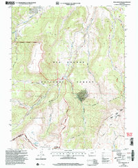
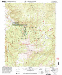
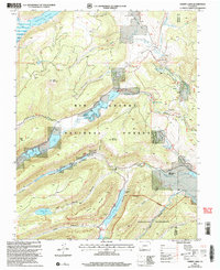
 2001 Mount Hope2005 Print · USGSMineral County at the start of the twenty-first century reveals a high-country landscape of protected wilderness and forest reserves. Outdoor researchers can trace alpine routes along the Continental Divide National Scenic Trail or locate landmarks like Big Meadows Reservoir and Mount Hope.
 - 2001 Map of Creede, 2005 Print
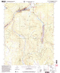
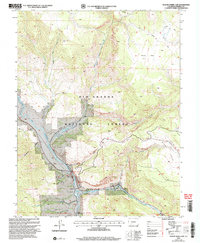
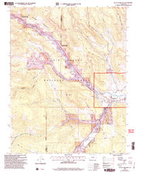
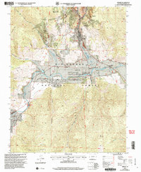 2001 Creede2005 Print · USGSMineral County mining culture and ranching history are preserved here at the dawn of the new millennium. Researchers can trace the silver-mining legacy through Bulldog Tunnel and Sunnyside (Site) or locate the historic Wason Ranch along the Rio Grande.
 - 2001 Map of Slumgullion Pass, 2005 Print
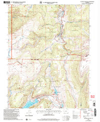 2001 Slumgullion Pass2005 Print · USGSThe high alpine terrain of Hinsdale and Mineral Counties is documented here at the turn of the millennium. Researchers can trace the Continental Divide as it winds past the Slumgullion Slide, Spring Creek Pass, and Continental Reservoir.
End of results
Showing maps 1-19 of 19
Top cities of Mineral County
Frequently asked questions
- What are the different types of historical maps available for Mineral County?
- What is the oldest map of Mineral County?
- Where can I purchase historical maps of Mineral County for my home or office?
- Where can I download high-res historical maps of Mineral County?
- Are there historical topographic maps available for Mineral County?
- Is there historical aerial imagery available for Mineral County?
- Where are historical maps of Mineral County sourced from?