1800s (19th Century) Maps of Montezuma County, Colorado
Explore 13 historic maps of Montezuma County from the 1800s (19th Century). These maps offer a rare glimpse into what life looked like during the 1800s — showing old roads, neighborhoods, homes, and landmarks that have changed or disappeared over time.
Whether you're researching your family's past, planning a metal detecting trip, or studying how Montezuma County's landscape evolved across the 1800s, these high-resolution maps are a powerful tool for exploring the history of this region.
- Focus on a specific era: All maps on this page are from the 1800s, giving you a focused view of this time period.
- See what’s changed: Compare century-old streets, trails, and buildings to today's modern landscape using overlays and satellite layers.
- Research with precision: Use these maps for genealogy, historical research, land use analysis, or educational projects.
- View, download, or print: Maps are fully viewable online in high resolution, and can be downloaded or printed for your own records.
Start exploring Montezuma County's history through authentic maps from the 1800s. This is your window into the past.
Montezuma County, CO maps
(13)- 1886 Map of Abajo
 1886 Abajo1886 Print · USGSSoutheastern Utah appears here in the late frontier era, centered on the early settlement of Bluff City along the San Juan River. Researchers can trace the path of the Old Spanish Trail or locate remote landmarks like Orejas del Oso and Abajo Peak.
 - 1889 Map of Chaco
 1889 Chaco1889 Print · USGSNorthwestern New Mexico appears here in the late nineteenth century as a frontier of emerging river settlements and high-desert springs. Researchers can trace early footprints at Farmington and Aztec, or locate watering points like Sheep Spring and Seven Lakes.
 - 1892 Map of Abajo
 1892 Abajo1892 Print · USGSSoutheastern Utah in the 1890s remained a remote frontier where settlement followed the river and historic paths. Researchers can trace early routes like the Old Spanish Trail and find the riverside location of Bluff City below the Abajo Mts.
 - 1892 Map of Chaco
 1892 Chaco1892 Print · USGSNorthwestern New Mexico in the late nineteenth century reveals the early river-side foundations of the Four Corners region. Genealogists and historians can trace the development of Farmington, Aztec, and Jewett along the San Juan River and the high desert outpost of Seven Lakes.5 unique versions available
 - 1892 Map of Canyon De Chelly
 1892 Canyon De Chelly1892 Print · USGSApache County's high desert and deep sandstone canyons are documented here in the early 1890s, shortly after the initial 1883 survey. Modern researchers can trace the intricate drainages of Canyon De Chelly and find early water sources like Hospitito Spring and Tatezaka Tank.5 unique versions available
 - 1893 Map of Abajo
 1893 Abajo1893 Print · USGSSoutheastern Utah and the Colorado border are documented in the late nineteenth century during a time of early settlement and regional surveying. Researchers can trace the path of the Old Spanish Trail and locate early sites like Bluff City near the Navajo Indian Res. Line.5 unique versions available
 - 1895 Map of La Plata, 1966 Print
 1895 La Plata1966 Print · USGSThe high peaks and mining basins of Southwest Colorado are captured here in the 1890s, when ore mills and mountain rail lines defined the economy. Trace the route of the Rio Grande Southern R. R. past the Columbus Mine and the remote settlement of Mayday.
 - 1897 Map of La Plata
 1897 La Plata1897 Print · USGSThe high peaks and mining camps of Southwest Colorado are captured here in the late nineteenth century. Genealogists and historians can trace early ranching at Menefee Ranch or locate rail stops along the Rio Grande Southern R. R. like Hesperus and Cima.
 - 1897 Map of Rico
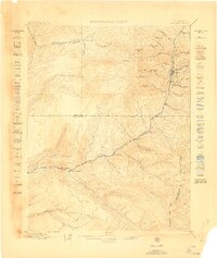
 1897 Rico1897 Print · USGSThe silver-mining hub of Rico is shown here in the late nineteenth century during its railroad-driven boom. Genealogists and researchers can locate family-named landmarks like Roger's Ranch and trace the winding route of the Rio Grande Southern R. R.
 - 1898 Map of Engineer Mountain, 1955 Print
 1898 Engineer Mountain1955 Print · USGSThe San Juan high country comes alive in this late nineteenth-century survey of the rugged terrain between Durango and Silverton. Researchers can trace early infrastructure like the Denver and Rio Grande RR, the Old Tollgate, and Hamor's Ranch.3 unique versions available
 - 1898 Map of Rico, 1957 Print
 1898 Rico1957 Print · USGSThe mining town of Rico and its surrounding peaks were a hub of activity in the late nineteenth century as the narrow-gauge railroad pushed through the mountains. Researchers can trace historic family holdings like Love's Ranch and the route of the Rio Grande Southern.
 - 1899 Map of La Plata
 1899 La Plata1899 Print · USGSThe high peaks of southwestern Colorado were a hive of industrial activity in the 1890s as railroads and mines pushed into the mountains. Researchers can trace the winding Rio Grande Southern R. R. and locate historic sites like Menefee Ranch, the Ute Coal Mine, and Parrott.
 - 1899 Map of Rico
 1899 Rico1899 Print · USGSThe mining town of Rico and the high San Juan peaks come into focus in the 1890s as the railroad pushes through the valley. Trace the early settlement of the West Dolores region via Waechter's Ranch, Montelores, and the winding Rio Grande Southern line.5 unique versions available
End of results
Showing maps 1-13 of 13
Top cities of Montezuma County
Frequently asked questions
- What are the different types of historical maps available for Montezuma County?
- What is the oldest map of Montezuma County?
- Where can I purchase historical maps of Montezuma County for my home or office?
- Where can I download high-res historical maps of Montezuma County?
- Are there historical topographic maps available for Montezuma County?
- Is there historical aerial imagery available for Montezuma County?
- Where are historical maps of Montezuma County sourced from?