1950s Maps of Washington County, Colorado
Explore 9 historic maps of Washington County from the 1950s. These maps offer a rare glimpse into what life looked like during the 1950s — showing old roads, neighborhoods, homes, and landmarks that have changed or disappeared over time.
Whether you're researching your family's past, planning a metal detecting trip, or studying how Washington County's landscape evolved across the 1950s, these high-resolution maps are a powerful tool for exploring the history of this region.
- Focus on a specific era: All maps on this page are from the 1950s, giving you a focused view of this time period.
- See what’s changed: Compare century-old streets, trails, and buildings to today's modern landscape using overlays and satellite layers.
- Research with precision: Use these maps for genealogy, historical research, land use analysis, or educational projects.
- View, download, or print: Maps are fully viewable online in high resolution, and can be downloaded or printed for your own records.
Start exploring Washington County's history through authentic maps from the 1950s. This is your window into the past.
Washington County, CO maps
(9)- 1951 Map of Messex, 1952 Print
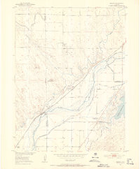 1951 Messex1952 Print · USGSEastern Colorado plains life in the early fifties revolves around the river and the rails. Trace family roots at the Roosevelt School or Merino Cemetery, and explore the vital irrigation systems including the Sterling Canal and Prewitt Reservoir.4 unique versions available
 - 1951 Map of Merino SW, 1952 Print
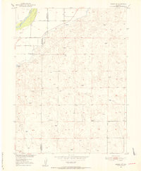 1951 Merino SW1952 Print · USGSNortheastern Colorado’s plains are captured here in the early fifties, documenting the remote ranching lands between Washington and Morgan counties. Researchers can trace rural life through the Highland School, the waters of Emerson Lake, and the winding South Platte River.5 unique versions available
 - 1951 Map of Merino SE, 1953 Print
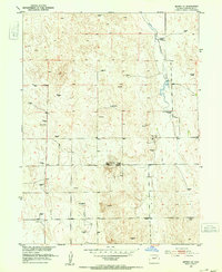 1951 Merino SE1953 Print · USGSThe Colorado high plains of Washington County appear here in the early fifties, a landscape defined by ranching and rural education. Genealogists and historians can locate family landmarks like the Flying YJ Ranch or trace the districts of the North Buena Vista School and South Buena Vista School.3 unique versions available
 - 1951 Map of Merino, 1953 Print
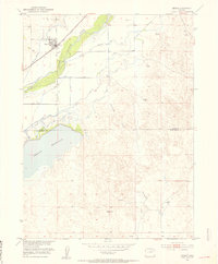 1951 Merino1953 Print · USGSMerino and the surrounding plains are captured in the early fifties, showcasing a landscape shaped by irrigation and the railroad. Genealogists and researchers can trace the Union Pacific line, the South Platte River corridor, and the waters of Prewitt Reservoir.3 unique versions available
 - 1954 Map of Limon
 1954 Limon1954 Print · USGSThe Eastern Colorado plains and the Kansas borderlands come alive in the mid-fifties, showing the vital rail-and-road corridor through Limon. Genealogists and historians can trace the Chicago Rock Island & Pacific line through Burlington and find remote outposts like Arickaree and Anton.4 unique versions available
 - 1954 Map of Sterling
 1954 Sterling1954 Print · USGSNortheastern Colorado and the Nebraska borderlands are defined by the river-and-rail corridors of the mid-twentieth century. Researchers can trace the development of agricultural hubs from Sterling and Fort Morgan to smaller rail stops along the Union Pacific and Burlington Northern lines.3 unique versions available
 - 1957 Map of Limon
 1957 Limon1957 Print · USGSThe High Plains of Eastern Colorado and Western Kansas come alive in the mid-1950s, showing the vital rail-and-road connections of the era. You can trace the path of the Chicago Rock Island and Pacific through towns like Limon, Stratton, and Burlington or find the early footprint of Bonny Reservoir.
 - 1958 Map of Limon
 1958 Limon1958 Print · USGSEastern Colorado and the Kansas border meet in this late-fifties study of High Plains rail and river systems. Researchers can trace the path of the Chicago Rock Island and Pacific through Limon and Burlington, or locate the Bonny Dam and Bonny Reservoir.
 - 1958 Map of Sterling
 1958 Sterling1958 Print · USGSNortheastern Colorado thrived along the river and rail corridors during the late fifties. Genealogists and historians can trace family-named irrigation works like Davis Brothers Ditch and agricultural hubs from Peetz to Fort Morgan.
End of results
Showing maps 1-9 of 9
Top cities of Washington County
Frequently asked questions
- What are the different types of historical maps available for Washington County?
- What is the oldest map of Washington County?
- Where can I purchase historical maps of Washington County for my home or office?
- Where can I download high-res historical maps of Washington County?
- Are there historical topographic maps available for Washington County?
- Is there historical aerial imagery available for Washington County?
- Where are historical maps of Washington County sourced from?