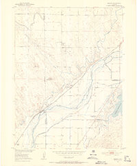
1951 Map of Messex
USGS Topo · Published 1952This historical map portrays the area of Messex in 1951, primarily covering Logan County as well as portions of Morgan County and Washington County. Featuring a scale of 1:24000, this map provides a highly detailed snapshot of the terrain, roads, buildings, counties, and historical landmarks in the Messex region at the time. Published in 1952, it is one of 4 known editions of this map due to revisions or reprints.
Find a feature on this map
26 named features on this map. Tap any name to fly to it.
Don’t see what you’re looking for? This feature index may not catch every label — zoom into the map to look around manually.
Map Details
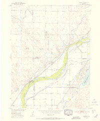
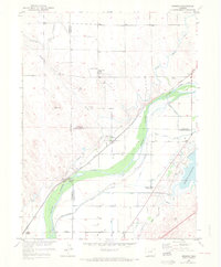
Editions of this 1951 Messex Map
4 editions found
Historical Maps of Washington County Through Time
36 maps found

1951 Atwood NE
Logan County, CO

1951 Galien
Logan County, CO

1951 Messex
Logan County, CO

1951 Padroni NW
Logan County, CO

1951 Reiradon Hill
Logan County, CO

1951 Sterling North
Logan County, CO

1951 Sterling South
Logan County, CO

1951 Wild Horse Lake
Logan County, CO

1951 Willard
Logan County, CO

1953 Haystack Butte
Logan County, CO

1953 Julesburg Reservoir
Logan County, CO

1953 Proctor
Logan County, CO

1953 Tamarack Ranch
Logan County, CO

1953 Twin Buttes
Logan County, CO

1962 Haxtun West
Logan County, CO

1962 Uhler Ranch
Logan County, CO

1971 Messex
Logan County, CO

1971 Twin Buttes
Logan County, CO

1972 Glacken Hill
Logan County, CO

1972 Leroy
Logan County, CO

1972 New Haven
Logan County, CO

1972 Rockland
Logan County, CO

1972 St Petersburg
Logan County, CO

1973 Buffalo Springs Ranch NE
Logan County, CO

1973 Buffalo Springs Ranch NW
Logan County, CO

1977 Avalo SE
Logan County, CO

1977 Dipper Spring
Logan County, CO

1977 Stoneham NE
Logan County, CO

1978 Chimney Canyons
Logan County, CO

1978 Kirchnavy Butte
Logan County, CO

1978 North Sterling Reservoir
Logan County, CO

1978 Stoneham SE
Logan County, CO

1978 Westplains
Logan County, CO

1997 Avalo SE
Logan County, CO

1997 Dipper Spring
Logan County, CO

1997 Stoneham NE
Logan County, CO