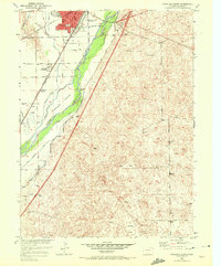
1951 Map of Sterling South
USGS Topo · Published 1972About this map
The South Platte River and its intricate network of irrigation channels define this landscape south of Sterling. Water management is the central theme of the terrain, with the Lowline Ditch, Batten Ditch, and Schneider Ditch branching off to support the local agriculture that fed the prominent Sugar Factory. The river itself creates complex landforms like Hadfield Island, while the presence of the Burlington Northern and Union Pacific railroads underscores the city's role as a regional transportation hub during the mid-twentieth century.
Find a feature on this map
28 named features on this map. Tap any name to fly to it.
Don’t see what you’re looking for? This feature index may not catch every label — zoom into the map to look around manually.
Map Details
Editions of this 1951 Sterling South Map
4 editions found
Other maps of this area

1951 · Reiradon Hill
USGS Topo · 1:24,000

1951 · Sterling South
USGS Topo · 1:24,000

1951 · Sterling North
USGS Topo · 1:24,000

1951 · Galien
USGS Topo · 1:24,000

1951 · Atwood NE
USGS Topo · 1:24,000

1951 · Merino
USGS Topo · 1:24,000

1951 · Atwood
USGS Topo · 1:24,000

1954 · Sterling
USGS Topo · 1:250,000

1958 · Sterling
USGS Topo · 1:250,000

1971 · Merino
USGS Topo · 1:24,000