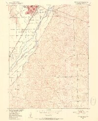
1951 Map of Sterling South
USGS Topo · Published 1952About this map
Sterling anchors this mid-century Logan County landscape, serving as a hub for both industrial and agricultural activity along the South Platte River. The local economy is visibly centered on the Sugar Factory and a complex irrigation network of ditches, including the Springdale Ditch and Henderson Smith Ditch, which support the surrounding Jones Flat. The town's civic infrastructure is well-defined, featuring the Franklin Sch, Columbine Sch, a Courthouse, and the Overland Trail Park and Museum near the riverbanks.
Find a feature on this map
35 named features on this map. Tap any name to fly to it.
Don’t see what you’re looking for? This feature index may not catch every label — zoom into the map to look around manually.
Map Details
Editions of this 1951 Sterling South Map
4 editions found
Other maps of this area

1951 · Reiradon Hill
USGS Topo · 1:24,000

1951 · Sterling South
USGS Topo · 1:24,000

1951 · Sterling North
USGS Topo · 1:24,000

1951 · Galien
USGS Topo · 1:24,000

1951 · Atwood NE
USGS Topo · 1:24,000

1951 · Merino
USGS Topo · 1:24,000

1951 · Atwood
USGS Topo · 1:24,000

1954 · Sterling
USGS Topo · 1:250,000

1958 · Sterling
USGS Topo · 1:250,000

1971 · Merino
USGS Topo · 1:24,000