
1953 Map of Proctor
USGS Topo · Published 1985About this map
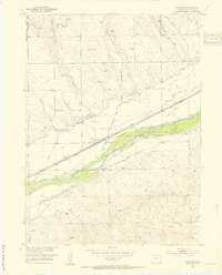
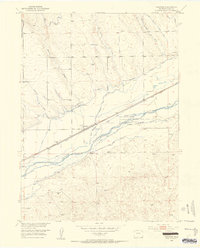
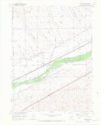
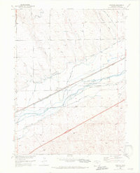
Proctor and the South Platte River corridor anchor this mid-century survey of the Colorado plains. The landscape is defined by an intricate network of irrigation infrastructure essential to High Plains agriculture, including the Harmony No 2 Ditch, Powell Ditch, and the Lone Tree Ditch. Along the southern banks of the river, the Tamarack Ranch State Wildlife Area marks a significant tract of managed riverside terrain. The Union Pacific railroad cuts a straight diagonal through the valley, paralleling the river and connecting the small settlement of Proctor to the wider regional economy. To the northwest, the North Sterling Outlet Canal and Sterling Outlet Levee showcase large-scale water management efforts, while various family-named landmarks like Ramsey Draw and Skinner Draw provide points of reference across the open range.
Find a feature on this map
25 named features on this map. Tap any name to fly to it.
Don’t see what you’re looking for? This feature index may not catch every label — zoom into the map to look around manually.
Map Details
Editions of this 1953 Proctor Map
5 editions found
Historical Maps of Proctor Through Time
191 maps found

1951 Atwood NE
Logan County, CO

1951 Galien
Logan County, CO

1951 Messex
Logan County, CO

1951 Padroni NW
Logan County, CO

1951 Reiradon Hill
Logan County, CO

1951 Sterling North
Logan County, CO

1951 Sterling South
Logan County, CO

1951 Wild Horse Lake
Logan County, CO

1951 Willard
Logan County, CO

1953 Haystack Butte
Logan County, CO

1953 Julesburg Reservoir
Logan County, CO
1953 Proctor
Logan County, CO

1953 Tamarack Ranch
Logan County, CO

1953 Twin Buttes
Logan County, CO

1962 Haxtun West
Logan County, CO

1962 Uhler Ranch
Logan County, CO

1971 Messex
Logan County, CO

1971 Twin Buttes
Logan County, CO

1972 Glacken Hill
Logan County, CO

1972 Leroy
Logan County, CO

1972 New Haven
Logan County, CO

1972 Rockland
Logan County, CO

1972 St Petersburg
Logan County, CO

1973 Buffalo Springs Ranch NE
Logan County, CO

1973 Buffalo Springs Ranch NW
Logan County, CO

1977 Avalo SE
Logan County, CO

1977 Dipper Spring
Logan County, CO

1977 Stoneham NE
Logan County, CO

1978 Chimney Canyons
Logan County, CO

1978 Kirchnavy Butte
Logan County, CO

1978 North Sterling Reservoir
Logan County, CO

1978 Stoneham SE
Logan County, CO

1978 Westplains
Logan County, CO

1997 Avalo SE
Logan County, CO

1997 Dipper Spring
Logan County, CO

1997 Stoneham NE
Logan County, CO

2010 Atwood NE
Logan County, CO

2010 Buffalo Springs Ranch NE
Logan County, CO

2010 Buffalo Springs Ranch NW
Logan County, CO

2010 Chimney Canyons
Logan County, CO

2010 Galien
Logan County, CO

2010 Glacken Hill
Logan County, CO

2010 Haxtun West
Logan County, CO

2010 Haystack Butte
Logan County, CO

2010 Julesburg Reservoir
Logan County, CO

2010 Kirchnavy Butte
Logan County, CO

2010 Leroy
Logan County, CO

2010 Messex
Logan County, CO

2010 New Haven
Logan County, CO

2010 North Sterling Reservoir
Logan County, CO

2010 Padroni NW
Logan County, CO

2010 Proctor
Logan County, CO

2010 Reiradon Hill
Logan County, CO

2010 Rockland
Logan County, CO

2010 Saint Petersburg
Logan County, CO

2010 Sterling North
Logan County, CO

2010 Sterling South
Logan County, CO

2010 Tamarack Ranch
Logan County, CO

2010 Twin Buttes
Logan County, CO

2010 Uhler Ranch
Logan County, CO

2010 Westplains
Logan County, CO

2010 Wild Horse Lake
Logan County, CO

2010 Willard
Logan County, CO

2011 Avalo SE
Logan County, CO

2011 Dipper Spring
Logan County, CO

2011 Stoneham NE
Logan County, CO

2011 Stoneham SE
Logan County, CO

2013 Atwood NE
Logan County, CO

2013 Avalo SE
Logan County, CO

2013 Buffalo Springs Ranch NE
Logan County, CO

2013 Buffalo Springs Ranch NW
Logan County, CO

2013 Chimney Canyons
Logan County, CO

2013 Dipper Spring
Logan County, CO

2013 Galien
Logan County, CO

2013 Glacken Hill
Logan County, CO

2013 Haxtun West
Logan County, CO

2013 Haystack Butte
Logan County, CO

2013 Julesburg Reservoir
Logan County, CO

2013 Kirchnavy Butte
Logan County, CO

2013 Leroy
Logan County, CO

2013 Messex
Logan County, CO

2013 New Haven
Logan County, CO

2013 North Sterling Reservoir
Logan County, CO

2013 Padroni NW
Logan County, CO

2013 Proctor
Logan County, CO

2013 Reiradon Hill
Logan County, CO

2013 Rockland
Logan County, CO

2013 Saint Petersburg
Logan County, CO

2013 Sterling North
Logan County, CO

2013 Sterling South
Logan County, CO

2013 Stoneham NE
Logan County, CO

2013 Stoneham SE
Logan County, CO

2013 Tamarack Ranch
Logan County, CO

2013 Twin Buttes
Logan County, CO

2013 Uhler Ranch
Logan County, CO

2013 Westplains
Logan County, CO

2013 Wild Horse Lake
Logan County, CO

2013 Willard
Logan County, CO

2016 Atwood NE
Logan County, CO

2016 Avalo SE
Logan County, CO

2016 Buffalo Springs Ranch NE
Logan County, CO

2016 Buffalo Springs Ranch NW
Logan County, CO

2016 Chimney Canyons
Logan County, CO

2016 Dipper Spring
Logan County, CO

2016 Galien
Logan County, CO

2016 Glacken Hill
Logan County, CO

2016 Haxtun West
Logan County, CO

2016 Haystack Butte
Logan County, CO

2016 Julesburg Reservoir
Logan County, CO

2016 Kirchnavy Butte
Logan County, CO

2016 Leroy
Logan County, CO

2016 Messex
Logan County, CO

2016 New Haven
Logan County, CO

2016 North Sterling Reservoir
Logan County, CO

2016 Padroni NW
Logan County, CO

2016 Proctor
Logan County, CO

2016 Reiradon Hill
Logan County, CO

2016 Rockland
Logan County, CO

2016 Saint Petersburg
Logan County, CO

2016 Sterling North
Logan County, CO

2016 Sterling South
Logan County, CO

2016 Stoneham NE
Logan County, CO

2016 Stoneham SE
Logan County, CO

2016 Tamarack Ranch
Logan County, CO

2016 Twin Buttes
Logan County, CO

2016 Uhler Ranch
Logan County, CO

2016 Westplains
Logan County, CO

2016 Wild Horse Lake
Logan County, CO

2016 Willard
Logan County, CO

2019 Atwood NE
Logan County, CO

2019 Avalo SE
Logan County, CO

2019 Buffalo Springs Ranch NE
Logan County, CO

2019 Buffalo Springs Ranch NW
Logan County, CO

2019 Chimney Canyons
Logan County, CO

2019 Dipper Spring
Logan County, CO

2019 Galien
Logan County, CO

2019 Glacken Hill
Logan County, CO

2019 Haxtun West
Logan County, CO

2019 Haystack Butte
Logan County, CO

2019 Julesburg Reservoir
Logan County, CO

2019 Kirchnavy Butte
Logan County, CO

2019 Leroy
Logan County, CO

2019 Messex
Logan County, CO

2019 New Haven
Logan County, CO

2019 North Sterling Reservoir
Logan County, CO

2019 Padroni NW
Logan County, CO

2019 Proctor
Logan County, CO

2019 Reiradon Hill
Logan County, CO

2019 Rockland
Logan County, CO

2019 Saint Petersburg
Logan County, CO

2019 Sterling North
Logan County, CO

2019 Sterling South
Logan County, CO

2019 Stoneham NE
Logan County, CO

2019 Stoneham SE
Logan County, CO

2019 Tamarack Ranch
Logan County, CO

2019 Twin Buttes
Logan County, CO

2019 Uhler Ranch
Logan County, CO

2019 Westplains
Logan County, CO

2019 Wild Horse Lake
Logan County, CO

2019 Willard
Logan County, CO

2022 Atwood NE
Logan County, CO

2022 Avalo SE
Logan County, CO

2022 Buffalo Springs Ranch NE
Logan County, CO

2022 Buffalo Springs Ranch NW
Logan County, CO

2022 Chimney Canyons
Logan County, CO

2022 Dipper Spring
Logan County, CO

2022 Galien
Logan County, CO

2022 Glacken Hill
Logan County, CO

2022 Haxtun West
Logan County, CO

2022 Haystack Butte
Logan County, CO

2022 Julesburg Reservoir
Logan County, CO

2022 Kirchnavy Butte
Logan County, CO

2022 Leroy
Logan County, CO

2022 Messex
Logan County, CO

2022 New Haven
Logan County, CO

2022 North Sterling Reservoir
Logan County, CO

2022 Padroni NW
Logan County, CO

2022 Proctor
Logan County, CO

2022 Reiradon Hill
Logan County, CO

2022 Rockland
Logan County, CO

2022 Saint Petersburg
Logan County, CO

2022 Sterling North
Logan County, CO

2022 Sterling South
Logan County, CO

2022 Stoneham NE
Logan County, CO

2022 Stoneham SE
Logan County, CO

2022 Tamarack Ranch
Logan County, CO

2022 Twin Buttes
Logan County, CO

2022 Uhler Ranch
Logan County, CO

2022 Westplains
Logan County, CO

2022 Wild Horse Lake
Logan County, CO

2022 Willard
Logan County, CO