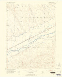
1953 Map of Proctor
USGS Topo · Published 1954About this map
The South Platte River carves through the landscape of northeastern Colorado, anchoring a complex system of irrigation essential to the high plains. In this mid-century survey, the tiny settlement of Proctor sits along the Union Pacific railroad line, serving as a hub for the surrounding ranching and agricultural interests. The map reveals an intricate network of water management, including the North Sterling Outlet Levee and various man-made channels like the Harmony No 2 Ditch and Powell Ditch. These features reflect the era's intensive efforts by the Department of the Interior to develop the Missouri River Basin. To the south of the river, the Colorado Game and Fish Reserve provides a protected area amid the varied terrain of the Iliff Valley, while numerous windmills and gravel pits dot the draws and canyons, marking the human footprint on this semi-arid terrain.
Find a feature on this map
31 named features on this map. Tap any name to fly to it.
Don’t see what you’re looking for? This feature index may not catch every label — zoom into the map to look around manually.
Map Details
Editions of this 1953 Proctor Map
5 editions found
Other maps of this area

1951 · Galien
USGS Topo · 1:24,000

1951 · Iliff
USGS Topo · 1:24,000

1953 · Peetz
USGS Topo · 1:24,000

1953 · Crook
USGS Topo · 1:24,000

1953 · Twin Buttes
USGS Topo · 1:24,000

1953 · Proctor
USGS Topo · 1:24,000

1953 · Haystack Butte
USGS Topo · 1:24,000

1954 · Sterling
USGS Topo · 1:250,000

1958 · Sterling
USGS Topo · 1:250,000

1962 · Fleming
USGS Topo · 1:24,000