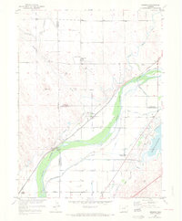
1951 Map of Messex
USGS Topo · Published 1972About this map
The South Platte River valley defines this mid-century landscape where agricultural irrigation meets early energy development. The complex network of waterways, including the Riverside Canal, North Sterling Canal, and Pawnee Ditch, illustrates the intensive water management required to sustain farming along the river corridor. Small rail settlements like Messex, Beta, and Balzac are positioned along the Union Pacific line, serving as vital transit points for the region's produce and resources.
Find a feature on this map
28 named features on this map. Tap any name to fly to it.
Don’t see what you’re looking for? This feature index may not catch every label — zoom into the map to look around manually.
Map Details
Editions of this 1951 Messex Map
4 editions found
Other maps of this area

1951 · Willard
USGS Topo · 1:24,000

1951 · Messex
USGS Topo · 1:24,000

1951 · Antelope Springs
USGS Topo · 1:24,000

1951 · Merino SW
USGS Topo · 1:24,000

1951 · Brush East
USGS Topo · 1:24,000

1951 · Merino SE
USGS Topo · 1:24,000

1951 · Merino
USGS Topo · 1:24,000

1951 · Atwood
USGS Topo · 1:24,000

1954 · Sterling
USGS Topo · 1:250,000

1958 · Sterling
USGS Topo · 1:250,000